Esk (North Yorkshire)

Esk (North Yorkshire)
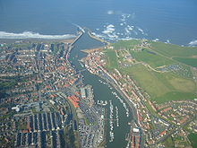
Luftaufnahme von Whitby mit der Esk-Mündung.

Der Esk ist ein Fluss in den North York Moors in North Yorkshire in England. Der 45 Kilometer lange Fluss entwässert ein Gebiet von 362 km². Er fließt aus einer Reihe von Quellen am Westerdale Moor durch das Esk Valley, bis er beim Hafenort Whitby direkt in die Nordsee mündet. Es ist damit der einzige größere Fluss in Yorkshire, der direkt in die Nordsee fließt.

Der Fluss fließt durch jurassischen Sandstein und Lias der North York Moors. Die Wasserqualität liegt aufgrund seiner Abgelegenheit im oberen Bereich. Einige Zuflüsse weisen jedoch zeitweise aufgrund stark saurer Zuflüsse aus den Moorgebieten biologisch schwierige Bedingungen auf. Etwa 50 Prozent des Einzugsgebiets bestehen aus Moor- und Heideland, das vor allem der Moorhuhnjagd dient und extensiv von Schafen beweidet wird. Die andere Hälfte besteht überwiegend aus landwirtschaftlichem Nutzland, hier fast ausschließlich der Weidehaltung.

Der Esk ist der einzige Fluss Yorkshires, in dem Lachse und Meerforellen leben. Darüber hinaus kommen an gefährdeten Arten Otter, Ostschermaus, Eisvogel, Wasseramsel und Flussperlmuschel vor. Obwohl die Wasserverschmutzung seit den 1970ern wieder zurückgegangen ist, konnte der Rückgang der Fischbestände nicht aufgehalten werden und dauert an. Wahrscheinlichste Ursache dafür ist der weiterhin schrumpfende Lebens- und Laichraum in Flussgebiet. Fischfang im Fluss lässt sich seit 1200 v. Chr. nachweisen, am bekanntesten ist er für Meerforelle und Lachs, aber auch Bachforelle und Äsche werden heute geangelt.

Aufgrund seiner Lage im Nationalpark ist der Esk ein populäres Besuchsziel: In den 1990ern kamen gut vier Millionen Touristen jährlich in das Esk Valley, vor allem um die Landschaft zu genießen. Der Fernwanderweg Esk Valley Walk läuft in Teilen neben dem Fluss her.

Literatur

  • North York Moors National Park Authority: River Esk Regeneration Programme July 1997–October 2001. 2001 ( als pdf)

Wikimedia Foundation.

Игры ⚽ Нужно решить контрольную?

Schlagen Sie auch in anderen Wörterbüchern nach:

  • River Esk, North Yorkshire — Infobox River | river name = River Esk caption = The River Esk near its mouth at Whitby origin =Westerdale Moor mouth = Whitby basin countries = England length = 45 km elevation = discharge = watershed = The River Esk is a river in North… …   Wikipedia

  • North Yorkshire Moors Railway — Three LNER Class A4 locomotives at Grosmont loco shed. Locale North Yorkshire …   Wikipedia

  • North Yorkshire Moors Railway — NYMR Bahnhof Goathland Streckenlänge: 29 km Spurweite: 1435 mm (Normalspur) Legende …   Deutsch Wikipedia

  • North Yorkshire — For other uses, see Yorkshire North. North Yorkshire Geography Status Ceremonial ( …   Wikipedia

  • North Yorkshire Council election, 2009 — Elections to North Yorkshire County Council took place on 4 June, 2009, having been delayed from 7 May, in order to coincide with elections to the European Parliament. Contents 1 Results 2 Divisional results 2.1 Craven district …   Wikipedia

  • Castleton, North Yorkshire — infobox UK place country = England official name= Castleton static static image caption=A view over Castleton latitude= longitude= population = shire district= shire county= North Yorkshire region= Yorkshire and the Humber constituency… …   Wikipedia

  • Malton, North Yorkshire — Coordinates: 54°08′20″N 0°47′31″W / 54.139°N 0.792°W / 54.139; 0.792 …   Wikipedia

  • Danby, North Yorkshire — Coordinates: 54°28′04″N 0°54′35″W / 54.467700°N 0.909700°W / 54.467700; 0.909700 …   Wikipedia

  • Grosmont, North Yorkshire — infobox UK place country = England official name = Grosmont latitude = 54.43563 longitude = 0.7239 population = 335 (2001 census) civil parish = Grosmont shire district = Scarborough region = Yorkshire and the Humber shire county = North… …   Wikipedia

  • Eskdale, North Yorkshire — Eskdale is a valley running west to east from Westerdale on the North Yorkshire Moors to Whitby on the east coast of England.Formed during the last major ice age, it has a classic U shaped valley formation caused by the action of glaciers carving …   Wikipedia

Share the article and excerpts

Direct link
Do a right-click on the link above
and select “Copy Link”