Fort Wadsworth Light

Fort Wadsworth Light

p4

Fort Wadsworth Light
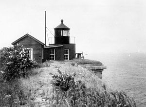
Ort: Staten Island, New York City, USA
Lage: East Verrazano Narrows
Geographische Lage 40° 36′ 21″ N, 74° 3′ 14″ W40.605833333333-74.053888888889Koordinaten: 40° 36′ 21″ N, 74° 3′ 14″ W
Feuerträgerhöhe: 4,5 m
Feuerhöhe: 22,5 m
Fort Wadsworth Light (New York)
Fort Wadsworth Light
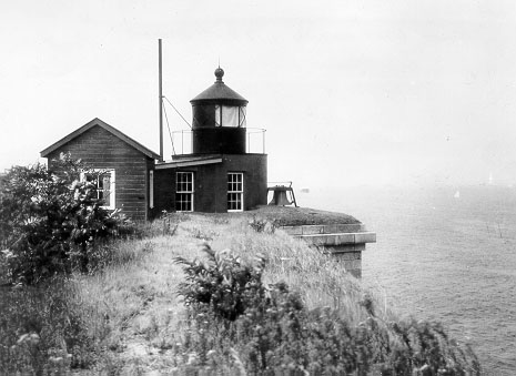
Optik: Fresnel-Linse vierter Ordnung
Bauzeit: 1903
Betriebszeit: 1903–1965
Internationale Ordnungsnummer: ARLHS: USA-301 [1]

Fort Wadsworth Light ist ein 1903 erbauter Leuchtturm oberhalb der Battery Weed auf Staten Island im New York Harbor. Das Leuchtfeuer markierte The Narrows, die Einfahrt zum New York Harbor. Es befindet sich unter der Verrazano-Narrows Bridge. Fort Wadsworth Light war ein Teil der Liegenschaften, die im März 1995 von der U.S. Navy an den National Park Service übertragen wurden, als die Gateway National Recreation Area eingerichtet wurde.

Die Tragweite des weißen Dauerlichtes betrug 14 Seemeilen (26 km). Die Optik wurde 1903 wahrscheinlich vom Fort Tompkins Light hierher verlegt. Die Freigabe der Verrazano-Narrows Bridge 1965 machte das Bauwerk obsolet. Nach vielen Jahren außer Betrieb wurde es restauriert und 2005 von Freiwilligen auf Solarbetrieb umgestellt.[2]

Belege

  1. ARLHS World List of Lights
  2. Lighthousefriends.com

Weblinks


Wikimedia Foundation.

Игры ⚽ Нужен реферат?

Schlagen Sie auch in anderen Wörterbüchern nach:

  • Fort Tompkins Light — was a lighthouse located on Staten Island in New York City on the westerley side of the Verrazano Narrows in New York Bay.The lighthouse was established by the Fort Tompkins Military Base in 1828 to guide ships to Staten Island. The lighthouse… …   Wikipedia

  • Crown Point Light — pre 1926 photograph of present Crown Point Light, showing attached keeper s house (USCG) Location on Crown Point on Lake Champlain Coordinates …   Wikipedia

  • Oswego Harbor West Pierhead Light — Oswego Harbor West Pierhead Lighthouse Location Oswego, New York Coordinates …   Wikipedia

  • Dunkirk Light — Location Point Gratiot on Lake Erie Year first constructed 1826 Year first lit 1875 Automated 1960 Foundation Dressed Stone Construction Rubblestone encased in brick Tower shape Square Marki …   Wikipedia

  • Oak Orchard Light — Location On Lake Ontario, at Point Breeze in New York Coordinates 43°22′16″N …   Wikipedia

  • Olcott Light — Location Olcott, New York, Lake Ontario Coordinates 43°20′20″N …   Wikipedia

  • Montauk Point Light — Montauk Point Lighthouse Location Montauk Point, Suffolk County, New York Year first lit 1797 Automated 1987 Foundation 13 ft (4 m) deep and 9 ft (3 m) thick, Natural, Emplaced, built in 1796 Constru …   Wikipedia

  • Esopus Meadows Light — 2000 Location West side of Hudson river Year first constructed 1839 Year first lit 1872 (current tower) Automated 1965 Deactivated 19652003 Foundation Granite pier on piles …   Wikipedia

  • Cold Spring Harbor Light — Location Entrance ot Cold Spring Harbor on Long Island Coordinates Preserved light …   Wikipedia

  • Old Field Point Light — Old Field Point Lighthouse Old Field Point Light Location Old Field, New York, Long Island north shore Coordinates …   Wikipedia

Share the article and excerpts

Direct link
Do a right-click on the link above
and select “Copy Link”