Quarantine Island

Quarantine Island

Vorlage:Infobox Insel/Wartung/Höhe fehlt

Quarantine Island
Blick über Port Chalmers zur Otago Peninsula. Quarantine Island ist auf der linken Bildseite sichtbar, Goat Island in der Bildmitte
Gewässer Otago Harbour, Pazifischer Ozean
Geographische Lage 45° 49′ 41,35″ S, 170° 37′ 59,81″ O-45.828154170.63328Koordinaten: 45° 49′ 41,35″ S, 170° 37′ 59,81″ O
Quarantine Island (Neuseeland)
Quarantine Island
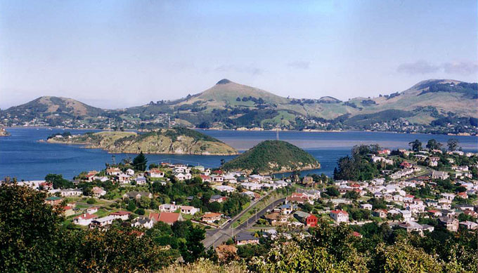
Fläche 0,15 km²
Quarantine Island von oberhalb des Portobello Marine Laboratory auf der Otago Peninsula. Das verbliebene Gebäude des Quarantänequartiers ist der zweigeschossige Bau in der Mitte. 2010 wurde es gesichert als Teil der Restaurierungsarbeiten

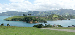
Quarantine Island/Kamau Taurua ist die größte Insel im Otago Harbour nahe der Stadt Dunedin, Neuseeland.

Die Insel hat eine Fläche von 15 Hektar und ist größtenteils eine öffentlich zugängliche Erholungsfläche. Die Hauptgebäude sind in die Liste des New Zealand Historic Places Trust[1] aufgenommen.

Die kleinere Insel Goat Island/Rangiriri liegt nahe an Quarantine Island. Beide Inseln liegen gegenüber dem Hafen zwischen der Stadt Port Chalmers und dem Portobello Marine Laboratory auf der Portobello Halbinsel.

Inhaltsverzeichnis

Geschichte

Zwischen 1863 und 1924 diente die Insel als Quarantäne-Station für in Otago ankommende Schiffe. Hatten die Mannschaften Infektionskrankheiten, wurden sie zur Insel geschickt, bis es ihnen besser ging oder sie starben. Auf der Insel gibt es einen kleinen Friedhof. Nachdem die Quarantänestation geschlossen worden war, wurde die Insel verpachtet. Seit 1958 nutzt die St Martin Island Community die Insel für Arbeit und Gottesdienst. In dieser Zeit wurde die Insel aufgeforstet.

Im Rahmen der Vereinbarung mit den Ngāi Tahu von 1996 erhielt die Insel als Teil des offiziellen Namens den ursprünglichen Māori-Namen Kamau Taurua, auf Deutsch Platz, um Netze zu stellen.[2]

Lediglich ein einziges Quarantänegebäude ist erhalten und wird gegenwärtig (2010) restauriert.

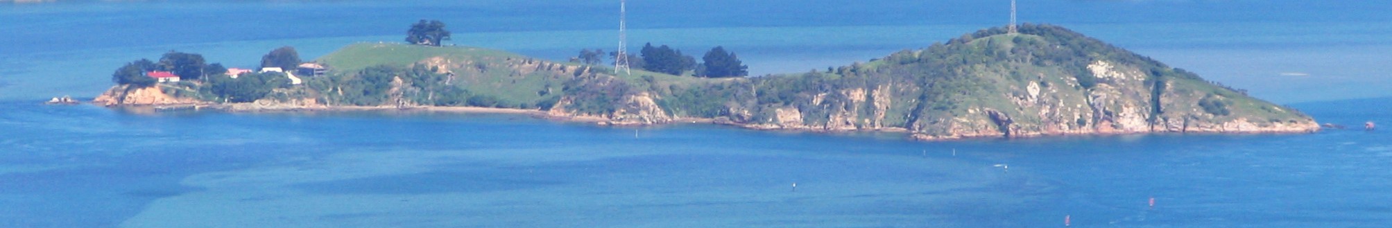
Nordöstliche Seite von Quarantine Island

Quellen

  • Peat, N & Patrick, B (2002) Wild Dunedin, University of Otago Press, Dunedin
  • Russell and McGeorge, P (2004) New Zealand's Islands, Bateman. [1]
  • Herd, J. & Griffiths, G.J. (1980). Discovering Dunedin. John McIndoe. ISBN 0-86868-030-3.
  • Hancock, L (2008) Quarantine Island / Kamau Taurua (St Martin Island) A short history St Martin Island Community, Dunedin. ISBN 978-0-473-14209-4 [2]

Weblinks

Einzelnachweise

  1. Quarantine Island/Kamau Taurua Historic Area (Englisch). Register of Historic Places. New Zealand Historic Places Trust. Abgerufen am 24. Januar 2009.
  2. Place Name Detail: Quarantine Island/Kamau Taurua. New Zealand Geographic Placenames Database. Land Information New Zealand. 24. Januar 2009.

Wikimedia Foundation.

Игры ⚽ Поможем сделать НИР

Schlagen Sie auch in anderen Wörterbüchern nach:

  • Saint Martin Island/Quarantine Island — Saint Martin Island (also known as Quarantine Island) is located in Otago Harbour, close to the city of Dunedin, New Zealand. Originally known as Kamau taurua , it has since gone by a variety of names, including Halfway Island and the two names… …   Wikipedia

  • Quarantine — For other uses see Quarantine (disambiguation) Quarantine is voluntary or compulsory isolation, typically to contain the spread of something considered dangerous, often but not always disease. The word comes from the Italian (seventeenth century… …   Wikipedia

  • quarantine — quarantinable, adj. quarantiner, n. /kwawr euhn teen , kwor , kwawr euhn teen , kwor /, n., v., quarantined, quarantining. n. 1. a strict isolation imposed to prevent the spread of disease. 2. a period, originally 40 days, of detention or… …   Universalium

  • Island restoration — The ecological restoration of islands, or island restoration, is the application of the principles of ecological restoration to islands and island groups. Islands, due to their isolation, are home to many of the world s endemic species, as well… …   Wikipedia

  • Goat Island (Otago) — Vorlage:Infobox Insel/Wartung/Fläche fehltVorlage:Infobox Insel/Wartung/Höhe fehlt Goat Island (Otago) Quarantine …   Deutsch Wikipedia

  • Sand Island (Hawaii) — Sand Island is a small island within the city of Honolulu, Hawaiokinai, United States. The island lies at the entrance to Honolulu Harbor. It was known as Quarantine Island during the nineteenth century when it was used to quarantine ships… …   Wikipedia

  • World of Monkey Island — The Monkey Island series takes place in a fictional world supposedly located deep within the Caribbean Sea and set roughly during the Golden Age of Piracy, some time in the late 17th century. The current article describes in game elements present …   Wikipedia

  • Goat Island, Otago Harbour — Goat Island is an island in Otago Harbour in Otago, in the southern South Island of New Zealand. It is located between Port Chalmers and Portobello, to the northeast of Dunedin s city centre.The second largest island in the harbour, Goat Island… …   Wikipedia

  • Cockspur Island — ▪ island, Georgia, United States also called  Long Island        island, Chatham county, southeastern Georgia, U.S., in the mouth of the Savannah River. Known during colonial times as Peeper Island, it was given the name Cockspur for the shape of …   Universalium

  • Swinburne Island — hospital, 1879 2008 from South Beach boardwalk …   Wikipedia

Share the article and excerpts

Direct link
Do a right-click on the link above
and select “Copy Link”