Karatia

Karatia

p1

Karatia
Karatia (Neuseeland)
Karatia
Koordinaten 34° 32′ S, 172° 51′ O-34.539933333333172.84918611111Koordinaten: 34° 32′ S, 172° 51′ O
Region Northland
Distrikt Far North Distrikt


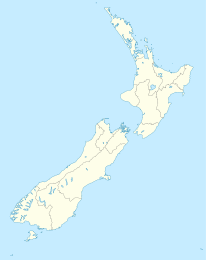
Karatia (auch Thoms Landing) ist eine Siedlung im Far North District in der Region Northland auf der Nordinsel Neuseelands. Sie liegt am State Highway 1 . Nächste Orte am Highway sind Waitiki Landing im Norden und Tangoake im Süden. Katatia liegt westlich des Südarmes der Snipe Bay, eines Arms des Parengarenga Harbour.

Die nächste größere Siedlung ist Te Kao etwa 15 km südöstlich, die nächstgelegene Stadt Kaitaia.

Einzelnachweise


Wikimedia Foundation.

Игры ⚽ Поможем сделать НИР

Schlagen Sie auch in anderen Wörterbüchern nach:

  • Government Saadat College — Infobox University name = Government Saadat College motto = আলোকিত মানুষ সৃষ্টি করা ( To create enlightened human being )cite news |first= |last=Annual college magazine|authorlink= |author= |coauthors= |title=Suborno joyonti soronika |url=… …   Wikipedia

  • Tangoake — p1 Tangoake …   Deutsch Wikipedia

  • Tofail Ahmed — (1920 at Baralia village, Lakshmipur District in Bangladesh ndash; 2002 in Dhaka, Bangladesh) was a well known Bangladeshi researcher of Folk Art. He was also a collector of Folk artifacts and has authored several books on Bangladeshi Folk arts… …   Wikipedia

  • Selim Al Deen — ( bn. সেলিম আল দীন) (18 August 1949 ndash; 14 January 2008) was a Bangladeshi playwright [ Citation last =Kamol first =Ersahad title =Silver Jubilee:Bangladesh Film Archive celebrations:Events on the 2nd day newspaper =The Daily Star year =2004… …   Wikipedia

  • Mordvinos — Мордва Mujeres Mordvinas Moksha (siglo XIX) y Erzya (2007) …   Wikipedia Español

  • Parengarenga Harbour — …   Deutsch Wikipedia

  • Waitiki Landing — p1 Waitiki Landing …   Deutsch Wikipedia

Share the article and excerpts

Direct link
Do a right-click on the link above
and select “Copy Link”