Katanning Shire

Katanning Shire
Shire of Katanning
Katanning LGA WA.png
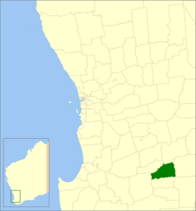
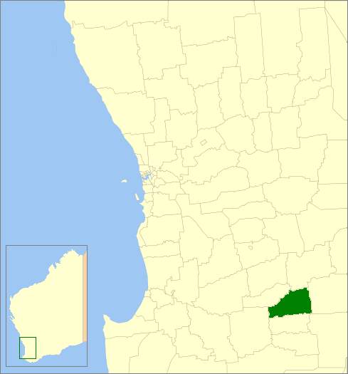
Lage des Katanning Shire in Westaustralien
Gliederung
Staat: Australien Australien
Bundesstaat: Flag of Western Australia.svg Western Australia
Verwaltungssitz: Katanning
Daten und Zahlen
Fläche: 1.518,5 km²
Einwohner: 4.210 (2006) [1]
Bevölkerungsdichte: 2,8 Einwohner je km²
-33.683333333333117.55

Das Shire of Katanning ist ein lokales Verwaltungsgebiet (LGA) im australischen Bundesstaat Western Australia. Das Gebiet ist 1519 km² groß und hat etwa 4200 Einwohner.

Katanning liegt im Südosten des Staates am Great Southern Highway etwa 250 km südöstlich der Hauptstadt Perth. Der Sitz des Shire Councils befindet sich in der Stadt Katanning, wo etwa 3800 Einwohner leben[2].

Verwaltung

Der Katanning Council hat acht Mitglieder. Sie werden von allen Bewohnern der LGA gewählt. Katanning ist nicht in Bezirke unterteilt. Aus dem Kreis der Councillor rekrutiert sich auch der Ratsvorsitzende und Shire President.

Quellen

  1. Australian Bureau of Statistics (25. Oktober 2007): Katanning (S) (Local Government Area) (Englisch). 2006 Census QuickStats. Abgerufen am 24. Juli 2010.
  2. Australian Bureau of Statistics (25. Oktober 2007): Katanning (Urban Centre/Locality) (Englisch). 2006 Census QuickStats. Abgerufen am 24. Juli 2010.

Weblinks


Wikimedia Foundation.

Игры ⚽ Нужно сделать НИР?

Schlagen Sie auch in anderen Wörterbüchern nach:

  • Katanning — Staat: Australien Bundesstaat …   Deutsch Wikipedia

  • Shire of Murchison — Western Australia Location in Western Australia Population …   Wikipedia

  • Shire of Derby-West Kimberley — Western Australia Population: 7,9 …   Wikipedia

  • Shire of Christmas Island — Population: 1,440(2009)[1] …   Wikipedia

  • Shire of Ngaanyatjarraku — Western Australia Location in Western Australia Population …   Wikipedia

  • Shire of Katanning — Infobox Australian Place | type = lga name = Shire of Katanning state = wa imagesize= 180 caption = Location in Western Australia pop = 4,210 (2006 census) density = area = 1518.5 est = 1892 seat = Katanning mayor = Phil Rae region = Great… …   Wikipedia

  • Shire of Broomehill-Tambellup — Infobox Australian Place | type = lga name = Shire of Broomehill Tambellup state = wa region = Great Southern area = 2609.1 seat = Tambellup pop = 1,121 (2006 census) est = 2008 density = imagesize = 180 caption = Location in Western Australia… …   Wikipedia

  • Shire of Broomehill — Infobox Australian Place | type = lga name = Shire of Broomehill state = wa imagesize= 180 caption = Location in Western Australia pop = 451 density = area = 1172.8 est = 1892 seat = Broomehill region = Great Southern near nw = Katanning near n …   Wikipedia

  • Katanning, Western Australia — Infobox Australian Place | type = town name = Katanning state = wa caption = Location of Katanning, Western Australia lga = Shire of Katanning postcode = 6317 est = 1898 pop = 3,808 (2006) elevation= 311 maxtemp = 22.1 mintemp = 9.3 rainfall =… …   Wikipedia

  • Shire of Woodanilling — Infobox Australian Place | type = lga name =Shire of Woodanilling state =wa region =Great Southern area =1129.0 seat =Woodanilling pop =379 (2001 census) density = imagesize = 180 caption = Location in Western Australia logo = logosize = url… …   Wikipedia

Share the article and excerpts

Direct link
Do a right-click on the link above
and select “Copy Link”