Kundang

Kundang
Kundang
13.663671413333-15.059492670833{{{elevation_save}}}Koordinaten: 13° 40′ N, 15° 4′ W
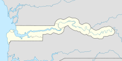
Karte: Gambia
marker
Region: Central River
Distrikt: Niamina East
Einwohner: 2.579 (2010)

EW3

Kundang (Schreibvariante: Kudang) ist eine Ortschaft im westafrikanischen Staat Gambia.

Nach einer Berechnung für das Jahr 2010 leben dort etwa 2579 Einwohner, das Ergebnis der letzten veröffentlichten Volkszählung von 1993 betrug 1781.[1]

Geographie

Kundang in der Central River Region im Distrikt Niamina East liegt am linken Ufer des Gambia-Flusses. Der Ort liegt unmittelbar an der South Bank Road, die hier nach Süden abknickt.

Die Distriktverwaltung „Niamina East Constituency“ befindet sich an diesem Ort.[2]

Siehe auch

Einzelnachweise

  1. Kundang in World Gazetteer, Zugriff Mai 2011
  2. Organisations located in Kundang - Gambia, Zugriff Mai 2011

Wikimedia Foundation.

Игры ⚽ Поможем сделать НИР

Schlagen Sie auch in anderen Wörterbüchern nach:

  • Malin Kundang — (also called Si Tanggang or Nakhoda Manis) is a Southeast Asian folktale about retribution on an ungrateful son. A sailor from a poor family, the protagonist sneaks onto a trading ship, eventually becoming rich, marrying a princess, and acquiring …   Wikipedia

  • Ladang Seri Kundang — Original name in latin Ladang Seri Kundang Name in other language Ladang Seri Kundang, Pengkalan Kundang State code MY Continent/City Asia/Kuala Lumpur longitude 3.2856 latitude 101.519 altitude 25 Population 23307 Date 2012 01 17 …   Cities with a population over 1000 database

  • Goenawan Mohamad — Born Goenawan Susatyo 29 July 1941 Batang, Central Java, Dutch East Indies (now Indonesia) Occupation poet, essayst, playwright, director …   Wikipedia

  • Assam Jawa-Templer Park Highway — Malaysian expressway routebox E =MES E|25 E25 Highway concessionaire s logo= length km=25 direction=West East start=Asam Jawa destinations=Kuala Selangor Ijok Puncak Alam Kuang Rawang end=Templer Park starting date= completion date=… …   Wikipedia

  • Jalan Kuang — Malaysia state road routebox code= JKR|B25 state= Selangor road= B25 length km= direction= North South start= Rawang destinations= Kuang Kundang Paya Jaras Batu Arang Batang Berjuntai end= Sungai Pelong construction date= completion date=… …   Wikipedia

  • Chang Naga — Chang Regions with significant populations Nagaland, India 16,075 (2001) [1] Languages …   Wikipedia

  • Minangkabau people — Minangkabau Minangkabau woman dressed in traditional clothes Total population circa 6 million Regions with significant populations …   Wikipedia

  • Muar town — Muar City Bandar Muar (Malay) 麻坡市 …   Wikipedia

  • MSC Malaysia — (formerly the Multimedia Super Corridor, and also known as the MSC in Malaysia). The Multimedia Super Corridor (MSC) program was launched by Dr Mahathir Mohamad, the former Prime Minister of Malaysia (1981 2003), circa 1996. The establishment of… …   Wikipedia

  • Cyberjaya — Sunset over Cyberjaya (2010) Cyberjaya is a town with a science park as the core that forms a key part of the Multimedia Super Corridor in Malaysia. It is located in the district of Sepang, Selangor and is situated about 50 km south of Kuala …   Wikipedia

Share the article and excerpts

Direct link
Do a right-click on the link above
and select “Copy Link”