Lake Hayes

Lake Hayes
Lake Hayes
Hays Lake
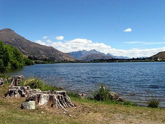
Lake Hayes.jpg
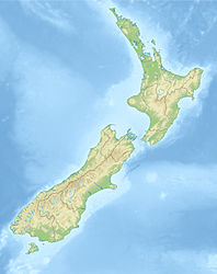
Geographische Lage Central Otago, Südinsel, Neuseeland
Daten
Koordinaten 44° 59′ 0″ S, 168° 48′ 0″ O-44.983333333333168.8Koordinaten: 44° 59′ 0″ S, 168° 48′ 0″ O
Lake HayesHays Lake (Neuseeland)
Lake HayesHays Lake


Lake Hayes ist ein kleiner See im Wakatipu Basin in Central Otago auf der Südinsel Neuseelands. Er liegt nahe den Orten Arrowtown und Queenstown. Der State Highway 6 führt an seiner Südseite entlang.

Der See hieß ursprünglich Hays Lake nach dem Australier D. Hay, der 1859 auf der Suche nach Land für die Schafzucht in das Gebiet kam. Später kam der Name Lake Hayes auf, da man seine Entdeckung irrtümlich einem ortsansässigen Original namens Captain "Bully" Hayes zuschrieb.

Der See litt seit 2006 unter Algenblüten durch die heimische Alge Ceratium hirundinella, die sein Wasser braun färbten. 2009 gab es keine Algenblüte mehr, Wissenschaftler führen dies auf das Auftreten des in Neuseeland nicht heimischen Wasserflohs Daphnia pulex im See zurück[1].

Einzelnachweise

  1. Otago Daily Times vom 4. September 2010

Wikimedia Foundation.

Игры ⚽ Нужно решить контрольную?

Schlagen Sie auch in anderen Wörterbüchern nach:

  • Lake Hayes — Infobox lake lake name = Lake Hayes Hays Lake image lake = caption lake = image bathymetry = caption bathymetry = location = Central Otago, South island coords = coord|44|59|S|168|48|E|region:NZ type:waterbody|display=inline,title type = inflow …   Wikipedia

  • Sturgeon Lake (Hayes Watershed - Kenora District, Ontario) — Infobox lake lake name = Sturgeon Lake image lake = caption lake = image bathymetry = caption bathymetry= location = Kenora District, Ontario coords = coord|55|23|48|N|90|54|19|W|region:CA ON type:waterbody|display=inline,title type = inflow =… …   Wikipedia

  • Hayes River — Der Hayes River mit York Factory, kurz vor der Mündung in die Hudson Bay um 1925Vorlage:Infobox Flus …   Deutsch Wikipedia

  • Lake Charlevoix — (top most body of water) Location Charlevoix County, Michigan Coordinates …   Wikipedia

  • Lake Elsinore, California — For the lake see Lake Elsinore. City of Lake Elsinore   City   View of Lake Elsinore and surrounding area …   Wikipedia

  • Lake Columbia — Infobox lake lake name = Lake Columbia image lake = lcmichigan.jpg caption lake = image bathymetry = caption bathymetry = location = Jackson County, Michigan coords= coord|42.0928|N|84.3011|W|region:US MI type:waterbody|display=inline,title… …   Wikipedia

  • Hayes Lake State Park — Geobox|Protected area name = Hayes Lake State Park category = Minnesota State Park category iucn = V image caption = country = United States country state = Minnesota state state type = State region type = County region = Roseau city type = City… …   Wikipedia

  • Hayes Route —    The main route of the fur traders, from Hudson Bay to Lake Winnipeg and the interior. It was adopted at a very early date, the more obvious route by way of Nelson River having proved impracticable. The Hayes route runs up Hayes River to Oxford …   The makers of Canada

  • Hayes River — Infobox River river name = Hayes River caption = origin = mouth =Hudson Bay basin countries = Canada length =483 km (300 mi) elevation = mouth elevation = discharge =590 m³/s (772 yd³/s) watershed = convert|108000|km2|sqmi| 3|abbr=onThe Hayes… …   Wikipedia

  • Lake Charles, Louisiana — For the lake, see Lake Charles (Louisiana). City of Lake Charles   City   Clockwise from left: Downtown Lake Charles; Lakefront Promenade; …   Wikipedia

Share the article and excerpts

Direct link
Do a right-click on the link above
and select “Copy Link”