Lawrenceville (Georgia)

Lawrenceville (Georgia)
Lawrenceville
Spitzname: The Crepe Myrtle City, L'ville, Lowdown
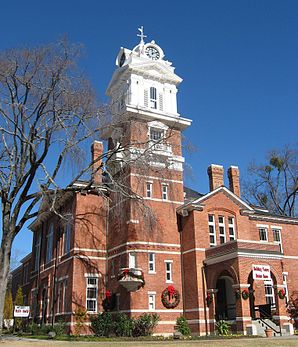
Gwinnett County Courthouse
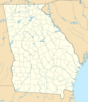
Lage in Georgia
Lawrenceville (Georgia)
Lawrenceville
Lawrenceville
Basisdaten
Staat: Vereinigte Staaten
Bundesstaat: Georgia
County:

Gwinnett County

Koordinaten: 33° 57′ N, 84° 0′ W33.953055555556-83.9925Koordinaten: 33° 57′ N, 84° 0′ W
Zeitzone: EST = UTC-5 (Sommer: EDT = UTC-4)
Einwohner: 29.837 (Stand: 2008)
Postleitzahlen: 30042, 30043, 30044, 30045, 30046 und 30049
Vorwahl: +1 404, 678 und 770
FIPS: 13-45488
GNIS-ID: 0316699
Webpräsenz: www.lawrencevillega.org/

Lawrenceville ist eine Stadt in den Vereinigten Staaten und der Verwaltungssitz von Gwinnett County.[1]

Inhaltsverzeichnis

Geschichte

Lawrenceville wurde durch die Georgia Generalversammlung am 15. Dezember 1821 eingemeindet. Die Stadt wurde benannt nach James Lawrence, Marineoffizier und Kommandeur der Fregatte Chesapeake im Krieg von 1812. Der Name der Stadt wurde vom ersten Leiter der Poststelle, William Maltbie zu Ehren des Wirkens von Lawrence vorgeschlagen.

Larry Flynt und sein Anwalt Gene Reeves Jr. wurden am 6. März 1978 in Lawrenceville nach einem Gerichtstermin durch Joseph Paul Franklin angeschossen. Beide überlebten den Anschlag, Flint wurde jedoch von der Hüfte abwärts gelähmt.

Trivia

  • Deion Sanders kaufte einst ein Stück Land in Lawrenceville um dort eine Villa zu errichten, verkaufte es jedoch wieder an Baufirmen.
  • Der Film Road Trip wurde zum Teil in Lawrenceville gedreht.

Weblinks

Einzelnachweise

  1. Find a County (englisch). Webpräsenz der National Association of Counties. Abgerufen am 21. Juni 2011.

Wikimedia Foundation.

Игры ⚽ Нужно решить контрольную?

Schlagen Sie auch in anderen Wörterbüchern nach:

  • Lawrenceville, Georgia — Infobox Settlement official name = Lawrenceville, Georgia other name = native name = nickname = The Crepe Myrtle City settlement type = City motto = imagesize = image caption = Gwinnett County Courthouse flag size = image seal size = image shield …   Wikipedia

  • Lawrenceville (Georgia) — Lawrenceville Pueblo de los Estados Unidos …   Wikipedia Español

  • Mountain View High School (Lawrenceville, Georgia) — Mountain View High School Address 2351 Sunny Hill Rd. Lawrenceville, Georgia, Gwinnett, 30043 United States Coordinates …   Wikipedia

  • Lawrenceville — ist der Name verschiedener Städte oder Stadtteile in den Vereinigten Staaten: Lawrenceville (Alabama), eine Stadt im US Bundesstaat Alabama Lawrenceville (Arkansas), eine Stadt im US Bundesstaat Arkansas Lawrenceville (Georgia), eine Stadt im US… …   Deutsch Wikipedia

  • Lawrenceville — is the name of several places in the United States: *Lawrenceville, Georgia *Lawrenceville, Illinois *Lawrenceville, Indiana *Lawrenceville, New Jersey **The Lawrenceville School *Lawrenceville, Ohio *Lawrenceville, Pennsylvania *Lawrenceville… …   Wikipedia

  • Georgia (U.S. state) locations by per capita income — Georgia is the tenth richest state in the United States of America, with a per capita income of $40,155 (2005). Georgia Places Ranked by Per Capita Income # Skidaway Island, Georgia ndash; $63,851 # Vernonburg, Georgia ndash; $49,391 # Daisy,… …   Wikipedia

  • Georgia Gwinnett College — Infobox University name = Georgia Gwinnett College established = Spring, 2005 type = Public undergrad = 788 cite web|url=http://www.usg.edu/research/students/enroll/fy2008/fall07.pdf |title=Semester Enrollment Report |accessdate=2007 12 23… …   Wikipedia

  • Lawrenceville — Lawrenceville, NJ U.S. Census Designated Place in New Jersey Population (2000): 4081 Housing Units (2000): 1776 Land area (2000): 1.039357 sq. miles (2.691923 sq. km) Water area (2000): 0.000000 sq. miles (0.000000 sq. km) Total area (2000):… …   StarDict's U.S. Gazetteer Places

  • Lawrenceville, GA — U.S. city in Georgia Population (2000): 22397 Housing Units (2000): 7684 Land area (2000): 12.991684 sq. miles (33.648306 sq. km) Water area (2000): 0.056368 sq. miles (0.145992 sq. km) Total area (2000): 13.048052 sq. miles (33.794298 sq. km)… …   StarDict's U.S. Gazetteer Places

  • Lawrenceville Highway — is a long road that runs through DeKalb and Gwinnett counties. The speed limit is mostly 45 mph. The towns it runs through are Decatur, Tucker, Lilburn, and Lawrenceville. It is Exit 38 off Interstate 285. Lawrenceville Highway is also signed as… …   Wikipedia

Share the article and excerpts

Direct link
Do a right-click on the link above
and select “Copy Link”