- Macmillan River
-
Macmillan River 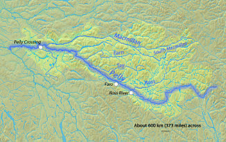
Verlauf des Macmillan River im Einzugsgebiet des Pelly River
Daten Lage Yukon-Territorium (Kanada) Flusssystem Yukon River Abfluss über Pelly River → Yukon River → Beringmeer Quelle in den Mackenzie Mountains Mündung östlich von Pelly Crossing in den Pelly River 62.8680555-135.8983333Koordinaten: 62° 52′ 5″ N, 135° 53′ 54″ W
62° 52′ 5″ N, 135° 53′ 54″ W62.8680555-135.8983333Länge 320 km Einzugsgebiet 13.800 km²[1] Abflussmenge[1] MNQ: 16 m³/s
MQ: 190 m³/s
MHQ: 456 m³/sLinke Nebenflüsse South Macmillan River Der Macmillan River ist ein 320 km langer rechter Nebenfluss des Pelly River im Yukon-Territorium im Nordwesten von Kanada. Er entspringt in den Mackenzie Mountains und fließt in überwiegend westlicher Richtung. Das Einzugsgebiet des Flusses erstreckt sich über 13800 km². Sein mittlerer Abfluss beträgt 190 m³/s.[1]
Erholung
Es werden Kanu- und Kajaktouren angeboten, die auf dem Nebenfluss South Macmillan River starten und über den Macmillan River nach Pelly Crossing, das am Pelly River ein kurzes Stück unterhalb der Mündung des Macmillan River liegt, führen und 16 bis 17 Tage dauern. Der Schwierigkeitsgrad der Wildwasserstrecken liegt bei III-IV.
Einzelnachweise
- ↑ a b c R-ArcticNET - Macmillan River near the mouth (Point ID 5805)
Weblinks
Kategorien:- Flusssystem Yukon River
- Fluss in Yukon
- Fluss in Nordamerika
Wikimedia Foundation.