Makaturing

Makaturing
Makaturing

Photo-request.svg

Bild gesucht 

BWf1

Höhe 1.940 m
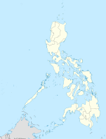
Lage Insel Mindanao, Philippinen
Geographische Lage 7° 39′ 16″ N, 124° 18′ 11″ O7.6544444444444124.303055555561940Koordinaten: 7° 39′ 16″ N, 124° 18′ 11″ O
Makaturing (Philippinen)
Makaturing
Typ Schichtvulkan
Letzte Eruption 1882

Der Makaturing ist ein 1.940 m hoher Schichtvulkan auf der Insel Mindanao auf den Philippinen

Der Berg liegt in der Provinz Lanao del Sur. Er erhebt sich an der Küstenlinie der Bucht von Illana, ca. 40 km südlich von Marawi City. Damit ist er der westlichste in einer Reihe von Vulkanen in Zentral-Mindanao, von denen der bekannteste der Vulkan Ragang in unmittelbarer Nachbarschaft des Makaturing ist. Ein weiter östlich gelegener Vulkan ist der Latukan.

Beim Makaturing wurden solfatarische Aktivitäten beobachtet. Die Smithsonian Institution nimmt als Zeitpunkt des letzten Ausbruchs des Vulkans das Jahr 1882 an, dies ist jedoch umstritten.

Quellen


Wikimedia Foundation.

Игры ⚽ Поможем написать курсовую

Schlagen Sie auch in anderen Wörterbüchern nach:

  • Mount Makaturing — Makaturing …   Wikipedia

  • Butig, Lanao del Sur — Infobox Philippine municipality infoboxtitle = Municipality of Butig locatormapfile = Ph locator lanao del sur butig.png caption = Map of Lanao del Sur showing the location of Butig region = Autonomous Region in Muslim Mindanao districts = 2nd… …   Wikipedia

  • Babuyan Claro — volcano is located in the Babuyan Islands, an archipelago in the Luzon Strait and north of Luzon island in the Philippines (19°31.5 N, 121° 57 E). It is separated from Luzon by the Babuyan Channel and from the Batanes Islands up north by the… …   Wikipedia

  • Cagua Volcano — is located in northern Luzon island in the Philippines (18°13.3 N, 122°7.4 E). It is in the political jurisdiction of the province of Cagayan in the Cagayan Valley region.Physical featuresVolcanologists classify Cagua Volcano as a stratovolcano… …   Wikipedia

  • Kanlaon — Infobox Mountain Name= Mount Kanla on Photo= Mount Kanla on.jpg Caption= Mount Kanla on Elevation=2435 metres Location= Negros Island, Philippines Prominence = 2435 metres pushpin pushpin label position = left pushpin map caption = pushpin… …   Wikipedia

  • Camiguin de Babuyanes — is an active volcano on Calayan Island, one of the Babuyan Islands, (18°50 N, 121°51.6 E) in the Philippines. It is under the political jurisdiction of the province of Cagayan in the admnistrative region of Cagayan Valley.Physical… …   Wikipedia

  • Iraya — Iraya, or Mount Iraya, is an active volcano on one of the Batanes Islands in the province of Batanes (20°29 N, 124°01 E) in the Philippines. It is the northernmost active volcano in the Philippines.Physical featuresIraya is a stratovolcano rising …   Wikipedia

  • Mount Ragang — Mount Ragang …   Wikipedia

  • Matutum — Volcano, is a volcano on the island of Mindanao in the Philippines. It is 15 km north of Polomolok, South Cotabato and about 30 km north northwest of General Santos City (6°22 N, 125°06.5 E).Physical featuresMatutum is a stratovolcano that rises… …   Wikipedia

  • Bucht von Illana — 7.4166667123.75 Koordinaten: 7° 25′ 0″ N, 123° 45′ 0″ O …   Deutsch Wikipedia

Share the article and excerpts

Direct link
Do a right-click on the link above
and select “Copy Link”