Middelgrundsfortet

Middelgrundsfortet

Vorlage:Infobox Insel/Wartung/Bild fehltVorlage:Infobox Insel/Wartung/Höhe fehlt

Middelgrundsfortet
Gewässer Ostsee
Geographische Lage 55° 43′ 13″ N, 12° 39′ 57″ O55.72027777777812.665833333333Koordinaten: 55° 43′ 13″ N, 12° 39′ 57″ O
Middelgrundsfortet (Hovedstaden)
Middelgrundsfortet
Länge 300 m
Breite 100 m
Fläche 7 ha

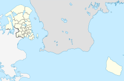
Middelgrundsfortet ist eine künstliche Insel in der Meerenge Öresund zwischen Seeland (Dänemark) und Schonen (Schweden), in der Verbindung der Ostsee mit dem Kattegat. Die Insel wurde 1890 von König Christian IX. als Seefestung aus Granit für militärische Zwecke errichtet. Sie ist 300 Meter lang, bis zu 180 Meter breit und hat eine Fläche von rund sieben Hektar. Middelgrundsfortet ist weltweit die größte künstliche Insel ohne Landverbindung. Die Insel befindet sich etwa 15 Bootsminuten vor Kopenhagen entfernt und besitzt einen offiziellen Hubschrauberlandeplatz. Die Insel ist mit etwa 15.000 m² bebaut und dient heute unter anderem touristischen Zwecken.

Literatur

Weblinks


Wikimedia Foundation.

Игры ⚽ Поможем написать курсовую

Schlagen Sie auch in anderen Wörterbüchern nach:

  • Middelgrundsfortet — is a sea fortress located in the Øresund between Copenhagen and Malmö. It was constructed 1890–94 as a part of Copenhagen s sea fortifications, partly from material excavated from Frihavnen. It was the largest sea fortress in the World, and is… …   Wikipedia

  • Middelgrundsfortet — er opført 1890 1891, blandt andet med fyld fra udgravningen af Frihavnen. Middelgrundsfortet var verdens største søfort. Det fyldte, inklusiv bølgebrydere, 7 hektar. I 2002 blev fortet solgt til en privat investor …   Danske encyklopædi

  • List of islands of Denmark — Map showing some of the larger islands This is a list of islands of Denmark. Contents 1 Overview 1.1 …   Wikipedia

  • Oresund — Estrecho de Oresund (Øresund Öresund) Océano o mar de la IHO (n.º id.: 2) Vista aérea del Oresund, con el puente …   Wikipedia Español

  • Øresund — Straits of Denmark and the southwestern Baltic Sea, big sea bridges in orange, sea tunnels in dark blue, dams in green. Øresund is at the top right. The Sound (locally known as Sundet, Danish Øresund, Danish pronunciation: [ˈøːɐsɔnˀ], or… …   Wikipedia

  • Møn — The title of this article contains the character ø. Where it is unavailable or not desired, the name may be represented as Moen. Møn The white chalk Cliffs of Møn …   Wikipedia

  • List of artificial islands — This is a list of artificial islands. Currently, artificial islands are an expensive but in some cases lucrative option for many cities having lack of land problems (such as Tokyo s Odaiba and Fukuoka s island city project.) In the future they… …   Wikipedia

  • North Jutlandic Island — Native name: Nørrejyske Ø The Grenen sand bar at the northern tip of the island …   Wikipedia

  • Mors (island) — Mors Hanklit, Mors Geography Location Limfjor …   Wikipedia

  • Fortifications of Copenhagen — The fortifications of Copenhagen can be classified historically as follows:* The medieval fortifications * The bastioned fortifications dating from the 1600s * The ring fortification system dating from the 1800s The ring fortification system… …   Wikipedia

Share the article and excerpts

Direct link
Do a right-click on the link above
and select “Copy Link”