- Mortlocks
-
Mortlocks Gewässer Pazifischer Ozean Archipel Karolinen Geographische Lage 6° 7′ N, 153° 5′ O6.1166666666667153.08333333333Koordinaten: 6° 7′ N, 153° 5′ O 

Anzahl der Inseln 6 Inseln und Atolle Hauptinsel Nama Gesamtfläche 11,911 km² Einwohner 6.911 (2000) Bundesstaat Chuuk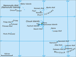
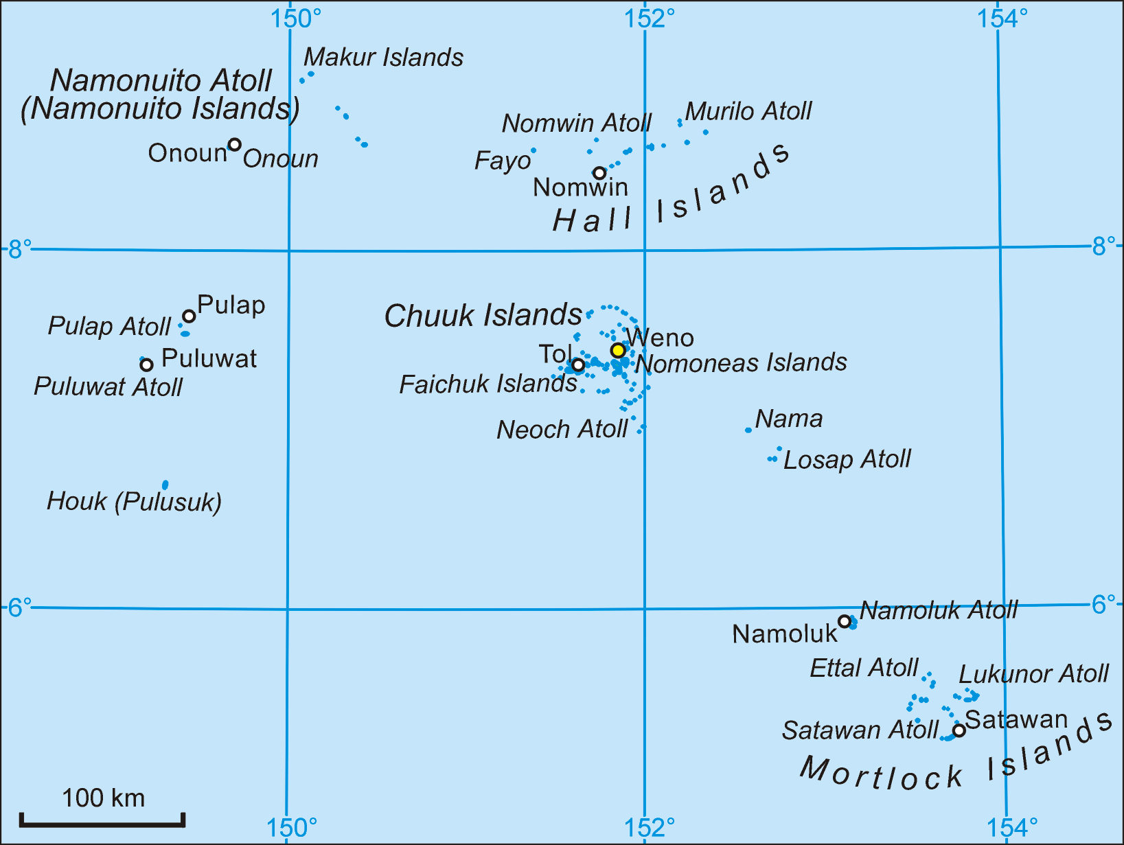
Die Mortlocks sind eine von fünf Inselregion des Bundesstaates Chuuk der Föderierten Staaten von Mikronesien. Sie gehören zum Archipel der Karolinen im zentralen Pazifischen Ozean. Vom Chuuk-Atoll aus erstrecken sie sich in südöstlicher Richtung. Die Gemeinden der Inselregion wurden statistisch gegliedert in die Unterregionen Upper Mortlocks, Mid Mortlocks und Lower Mortlocks.[1]. In neueren Veröffentlichungen ist diese Gliederung nicht mehr üblich.[2] Für eine geographische Gruppierung der Atolle (und der Einzelinsel Nama) wird gelegentlich nur zwischen upper Mortlocks (Nama, Losap, Namoluk) und lower Mortlocks (entspricht den Mortlock Islands) unterschieden.[3]
Die Inselregion weist eine aggregierte Landfläche von 11,911 km² auf (nach anderen Angaben 12,72 km²). Zur Volkszählung 2000 lebten 6911 Einwohner auf den Atollen und Einzelinseln.[2]
Die Atolle der Gruppe wurden erstmals 1795 von dem englischen Kapitän James Mortlock gesichtet, der sich mit dem Handelsschiff Young William auf der Heimreise von Australien nach England befand.
Die geographische Inselgruppe Mortlock Islands (Nomoi Islands) besteht aus den drei Atollen im Südwesten der Inselregion, Satawan, Etal und Lukunor.[4]
Inhaltsverzeichnis
Atolle
Folgende Atolle und Einzelinseln gehören zur Region der Mortlocks:
Atoll
(Insel)Land-
fläche
km²[5]Lagune
km²[6]Gesamt-
fläche
km²[7]Bevölkerung
2000[5]Inseln[5] Unter-
region[5]Gemeinden Losap 1,025 27,394 40 875 10 Upper Losap, Piis-Emwar Nama 0,748 - 0,748 995 1 Upper Nama Namoluk 0,834 7,697 13 407 5 Mid Namoluk Lukunor 2,822 55,027 67 1432 18 Lower Lekinioch, Oneop Etal 1,893 16,193 >20 267 20 Mid Ettal Satawan 4,589 382,087 419 2935 65 Mid
LowerMoch, Kuttu
Satowan, TaMortlocks 11,911 488,399 560 6911 119 Mortlocks 11 Gemeinden
Gemeinde
(municipality)Land-
fläche[1]Bevölkerung
2000[2]Unter-
regionAtoll/
InselLosap 0,85 448 Upper Losap Nama 0,75 995 Upper Nama Piis-Emwar 0,18 427 Upper Losap Ettal 1,89 267 Mid Etal Kuttu 0,28 873 Mid Satowan Namoluk 0,83 407 Mid Namoluk Moch 0,28 854 Mid Satowan Lekinioch 2,62 927 Lower Lukunor Oneop 0,47 505 Lower Lukunor Satowan 3,00 955 Lower Satowan Ta 1,55 253 Lower Satowan Mortlocks 12,72 6911 Mortlocks 6 Atolle/
InselnEinzelnachweise
- ↑ a b Chuuk 1989 Census
- ↑ a b c Chuuk 2000 Census
- ↑ Earl R. Hinz, Landfalls of Paradise, Cruising Guide to the Pacific Islands, 4th ed., University of Hawaii Press 1999
- ↑ Sailing Directions (enroute), Vol. 126, Pacific Ocean
- ↑ a b c d [http://www.botany.hawaii.edu/Pacific_Science/61/61.3buden02.pdf ]
- ↑ Otis W. Freeman, Geography of the Pacific, Wiley 1953 (auf metrisch umgerechnet)
- ↑ [ftp://rock.geosociety.org/pub/reposit/2001/2001075.pdf ] (Etal nach Satellitenbild geschätzt)
Weblinks

Wikimedia Foundation.