Mount Hutt

Mount Hutt
Mount Hutt
Mt Hutt.jpg
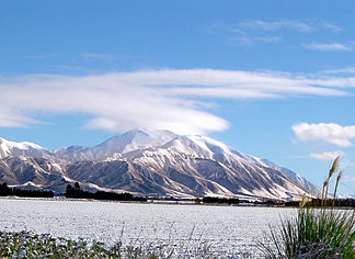
Höhe 2.086 m
Lage Südinsel Neuseelands
Gebirge Neuseeländische Alpen
Geographische Lage 43° 28′ 0″ S, 171° 32′ 0″ O-43.466666666667171.533333333332086Koordinaten: 43° 28′ 0″ S, 171° 32′ 0″ O
Mount Hutt (Neuseeland)
Mount Hutt
Besonderheiten Skigebiet

Mount Hutt ist ein 2086 m[1] hoher Berg westlich der Canterbury Plains auf Südinsel Neuseelands. Er überragt den Oberlauf des Rakaia River und ist etwa 80 km von der größten Stadt der Südinsel, Christchurch, entfernt.

Skigebiet

Auf dem Berg befindet sich ein Skigebiet mit einer Fläche von 3,65 km² (davon 42 Hektar[1] mit der Möglichkeit, Kunstschnee zu erzeugen) und einem Höhenunterschied von 683 m.[1] In dem Areal werden 4 Skilifte betrieben.[1]

Die Schneesaison dauert von Mai bis Oktober.[2] Mount Hutt rühmt sich, als erstes Skigebiet der Südhalbkugel die Saison zu eröffnen, und die längste Saison zu haben,[2] ist jedoch öfters wegen schlechter Wetterbedingungen geschlossen.

Am 12. August 2010 führten Winde mit bis zu 200 km/h zur Schließung des Gebietes und der Zufahrtsstraße, so dass 1200 Gäste bis zum nächsten Tag in den Gebäuden des Skigebietes untergebracht werden mussten.[3]

Da es auf dem Berg selbst keine Übernachtungsmöglichkeit gibt, übernachten viele Gäste in der Kleinstadt Methven. Das größere Ashburton und Christchurch sind etwa eine Stunde Fahrtzeit entfernt. Von Methven und Christchurch werden Zubringer angeboten.[1]

Das Gebiet wird zusammen mit denen am Coronet Peak und The Remarkables bei Queenstown von Southern Alpine Recreation Ltd. bewirtschaftet.

Einzelnachweise

  1. a b c d e Website von nzski.com zum Mount Hutt
  2. a b Mount Hutt auf 0800snow.co.nz
  3. Elizabeth Binning: Skiers freed as Mt Hutt road reopens. 13. August 2010. Abgerufen am 18. August 2010. 

Weblinks

 Commons: Mount Hutt – Sammlung von Bildern, Videos und Audiodateien

Wikimedia Foundation.

Игры ⚽ Поможем написать реферат

Schlagen Sie auch in anderen Wörterbüchern nach:

  • Mount Hutt (New Zealand) — Mount Hutt Mount Hutt rises to the west of the Canterbury Plains in the South Island of New Zealand, above the braided upper reaches of the Rakaia River, and 80 kilometres west of Christchurch. Its summit is 2190 metres above sea level. Skifield… …   Wikipedia

  • Mount Hutt, New Zealand — Mount Hutt rises to the west of the Canterbury Plains in the South Island of New Zealand, above the braided upper reaches of the Rakaia River, and 80 kilometres west of Christchurch. Its summit is 2190 metres above sea level.kifieldThe mountain… …   Wikipedia

  • Hutt — bezeichnet geographisch Hutt River Fluss in Neuseeland, siehe Hutt River (Neuseeland) Fluss in Australien, siehe Hutt River (Australien) Principality of Hutt River, Farm in Westaustralien, behauptet, ein von Australien unabhängiger souveräner… …   Deutsch Wikipedia

  • Mount Potts — is a specialist backcountry skiing base in South Island, New Zealand. Unlike normal resorts, there are no fixed ski tows or chairlifts. Instead, vertical transport is provided by snowcats and helicopter. The ski area covers 660 hectares and… …   Wikipedia

  • Mount Olympus Ski Area — Mt Olympus, on the LHS Location Canterbury NZ …   Wikipedia

  • Mount Cheeseman — is a club snowfield in New Zealand s South Island, near the town of Springfield, about an hour and a half from Christchurch. Situated in a south east facing basin, it features two T bar lifts and one learner tow. The runs cover an elevation range …   Wikipedia

  • Mount Somers — …   Wikipedia

  • Mount Victoria (New Zealand electorate) — Mount Victoria is a former New Zealand electorate, centred on the inner city suburb of Mount Victoria in the southern suburbs of Wellington. History The seat was held by only one MP, Jack Marshall of the National Party for the whole of its… …   Wikipedia

  • Mount Herbert (New Zealand electorate) — Mount Herbert was a former parliamentary electorate in the Canterbury Region of New Zealand, from 1866 to 1870. Contents 1 History 2 Members 3 Notes 4 References …   Wikipedia

  • Mount Ida (New Zealand electorate) — Mount Ida was a former parliamentary electorate in the Otago region of New Zealand, from 1871 to 1893, and then from 1902 to 1908. The electorate was represented by five Members of Parliament: David Hunter Mervyn from 1871 to 1875 Cecil Albert de …   Wikipedia

Share the article and excerpts

Direct link
Do a right-click on the link above
and select “Copy Link”