Mt. Natib

Mt. Natib
Mount Natib
Blick auf den Mt. Natib

Blick auf den Mt. Natib

Höhe 1.253 m
Lage Insel Luzon, Philippinen
Gebirge Zambales-Bergen,Philippinische Kordilleren
Geographische Lage 14° 42′ 43″ N, 120° 24′ 4″ O14.711944444444120.401111111111253Koordinaten: 14° 42′ 43″ N, 120° 24′ 4″ O
Mt. Natib (Philippinen)
Mt. Natib
Typ Schichtvulkan
Gestein Andesit, Dazit

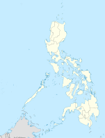
Der Mount Natib ist ein erloschener Schichtvulkan, der eine Höhe von 1.253 Meter über dem Meeresspiegel erreicht. Er liegt in den Zambales-Bergen, am nördlichen Ende der Bataan Halbinsel im Bataan Natural Park, südlich des Pinatubo Vulkans. Im Gipfelbereich des Natib erstreckt sich eine 6x7 km große Caldera und die kleinere Pasukulan Caldera.

Ein Ausbruch des Natib ist nicht bekannt, es wird jedoch vermutet das der letzte Ausbruch sich im späten Pleistozän oder der frühen Holozän ereignet hatte, eine genauere Untersuchung und Datierung steht noch aus. Im Bereich des Natib befinden sich mit den Mamot-, Tigulangin-, Uyong- und Paipit Springs mehrere Thermalquellen, deren Wassertemperatur zwischen 30 und 56° Celsius beträgt.

Der Natib wird vom „Philippine Institute of Volcanology and Seismology“ als „potenziell aktiv“ eingestuft.

Weblinks


Wikimedia Foundation.

Игры ⚽ Поможем написать курсовую

Schlagen Sie auch in anderen Wörterbüchern nach:

  • Mount Natib — Mt. Natib from the WSW Elevation 1,253 m (4,111 ft)  …   Wikipedia

  • Bataan — Lage von der Provinz Bataan Bataan Bataan ist eine philippinische Provinz im Bezirk Central Luzon auf …   Deutsch Wikipedia

  • Battle of Bataan — Infobox Military Conflict conflict=Battle of Bataan caption=Japanese soldiers celebrate victory on Bataan partof=World War II, Pacific theater date=7 January – 9 April, 1942 place=Bataan Peninsula near Manila Bay in Luzon Island, Philippines… …   Wikipedia

  • PH-BAN — Lage von der Provinz Bataan Bataan ist eine philippinische Provinz im Bezirk Central Luzon auf der Hauptinsel Luzón. Die gesamte Halbinsel Bataan, welche am Golf von Manila liegt, gehört zur Provinz. Im Norden grenzt sie an die beiden Provinzen… …   Deutsch Wikipedia

  • Campaña de Filipinas (1941-1942) — Saltar a navegación, búsqueda Campaña de Filipinas Parte de Frente del Sudoeste del Pacífico de la Segunda Guerra Mundial …   Wikipedia Español

  • Triple Goddess (Neopaganism) — This article discusses the Maiden, Mother, Crone goddess triad of certain forms of Neopaganism. See triple goddesses for other uses. The Triple Goddess is the subject of much of the writing of Robert Graves, and has been adopted by some neopagans …   Wikipedia

  • Liste von Vulkanen auf den Philippinen —  Karte mit allen Koordinaten: OSM, Google oder …   Deutsch Wikipedia

  • Bataan Peninsula — The Bataan Peninsula is a rocky extension of the Zambales Mountains, on Luzon in the Philippines. It separates the Manila Bay from the South China Sea. The peninsula features Mount Natib (1,253 m) in the north and the Mariveles Mountains in the… …   Wikipedia

  • Bataan — Infobox Philippine province name = Bataan sealfile = Ph seal bataan.png region = Central Luzon (Region III) capital = Balanga City founded = 1754 pop2000 = 557,659 pop2000rank = 46th largest popden2000 = 406 popden2000rank = 12th highest areakm2 …   Wikipedia

  • Jewitchery — (from the terms Jew and witch , shaman / sage in its pure meaning) or Jewish Neopaganism is a religious movement that seeks to create an earth based religion for the Jewish people. It mixes principles of Judaism, Neopaganism and the Kabbalah.… …   Wikipedia

Share the article and excerpts

Direct link
Do a right-click on the link above
and select “Copy Link”