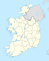
Mullaghareirk Mountains

Mullaghareirk Mountains

p1f1

Mullaghareirk Mountains
Mullach an Radhairc
Höchster Gipfel Mullaghareirk (408 m ASL)
Lage County Limerick, County Cork (Irland)
Mullaghareirk MountainsMullach an Radhairc (Irland)
Mullaghareirk MountainsMullach an Radhairc
Koordinaten 52° 20′ N, 9° 8′ W52.333333333333-9.1333333333333408Koordinaten: 52° 20′ N, 9° 8′ W

Die Mullaghareirk Mountains (irisch: Mullach an Radhairc, „der Gipfel der Aussicht“) sind eine Bergkette in Irland, die sich über eine Länge von 32 km zwischen den Städten Abbeyfeale und Dromcolliher in der Grafschaft Limerick und Newmarket in der Grafschaft Cork erstrecken. Die Ortschaften Mountcollins und Rockchapel liegen im Gebirge. Der höchste Erhebung wird mit 408 m erreicht.

Sowohl der River Feale als auch der Munster Blackwater entspringen in diesem Gebirge.


Wikimedia Foundation.

Игры ⚽ Нужно решить контрольную?

Schlagen Sie auch in anderen Wörterbüchern nach:

  • Mullaghareirk Mountains — The Mullaghareirk Mountains (from Irish: Mullach an Radhairc, meaning The summit of the view ) is a range of mountains in Ireland that stretches from the borders of County Kerry County Limerick to Newmarket, County Cork. The villages of… …   Wikipedia

  • List of mountains in Ireland — This is a list of mountains and mountain ranges on the island of Ireland. The list works around the island, beginning in Munster, and working anti clockwise. County allocations are based on where the majority of the mountain range lies.… …   Wikipedia

  • Comeragh Mountains — Na Comaraigh Comeragh Mountains Elevation …   Wikipedia

  • River Feale — Infobox River | river name = River Feale caption = River Feale at Finuge Crossing origin = Mullaghareirk Mountains, County Cork mouth = Atlantic at Shannon Estuary. The River Feale ( Abhainn na Feile in Irish) rises near Rockchapel in the… …   Wikipedia

  • Munster Blackwater — This article is about one of the Irish rivers called the Blackwater . For other rivers of a similar name, see River Blackwater, Ireland. Coordinates: 51°56′31″N 7°49′59″W / 51.942°N 7.833°W …   Wikipedia

  • Liste der Berge in Irland — Dies ist eine Liste von Gebirgen, Bergketten, einzelnen Bergen und nennenswerten Erhebungen in Irland. Die Auflistung beginnt in der Grafschaft County Kerry und wird geografisch gesehen entgegen dem Uhrzeigersinn fortgesetzt. Die Zuordnung der… …   Deutsch Wikipedia

  • Liste Des Montagnes D'Irlande — Liste des montagnes d’Irlande, classée par provinces. Sommaire 1 Munster 1.1 Comté de Cork 1.2 Comté de Kerry 1.3 Comté de Limerick …   Wikipédia en Français

  • Liste des montagnes d'Irlande — Liste des montagnes d’Irlande, classée par provinces. Sommaire 1 Munster 1.1 Comté de Cork 1.2 Comté de Kerry 1.3 Comté de Limerick …   Wikipédia en Français

  • Liste des montagnes d'irlande — Liste des montagnes d’Irlande, classée par provinces. Sommaire 1 Munster 1.1 Comté de Cork 1.2 Comté de Kerry 1.3 Comté de Limerick …   Wikipédia en Français

  • Carrauntoohil — Corrán Tuathail Carrauntoohil (middle) looking south along the Hag s Glen …   Wikipedia

Share the article and excerpts

Direct link
Do a right-click on the link above
and select “Copy Link”