Namuka-i-Lau

Namuka-i-Lau
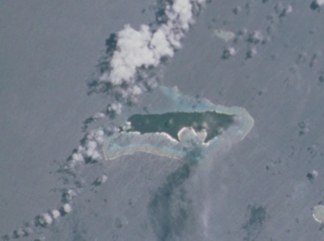
Namuka-i-Lau
NASA-Bild von Namuka-i-Lau
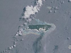
Gewässer Korosee
Inselgruppe Lau-Inseln
Geographische Lage 18° 50′ 52″ S, 178° 38′ 7″ W-18.847777777778-178.6352777777879Koordinaten: 18° 50′ 52″ S, 178° 38′ 7″ W
Namuka-i-Lau (Fidschi)
Namuka-i-Lau
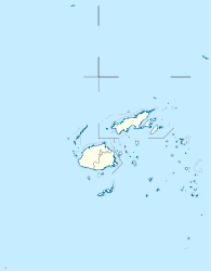
Länge 6,5 km
Breite 1,5 km
Fläche 5 km²
Höchste Erhebung 79 m
Hauptort Namuka

Namuka-i-Lau ist eine langgestreckte Insel vulkanischen Ursprungs im Lau-Archipel im Pazifischen Ozean. Politisch gehört sie zur Eastern Division des Inselstaates Fidschi.

Geographie

Namuka-i-Lau liegt im Süden des Lau-Archipels, 33 km nordöstlich von Kabara, 35 km nördlich von Fulaga sowie 30 km südwestlich von Moce. Sie ist 6,5 km lang, bis zu 1,5 km breit und weist eine Fläche von rund 5 km² auf. Die dicht bewaldete Insel ist bis auf einen Abschnitt im Nordwesten vollständig von einem Korallenriff umsäumt und erreicht eine Höhe von 79 m über dem Meer.[1] An der markanten Bucht im Süden der Insel liegt das einzige Dorf, Namuka,[2] das administrativ zum traditionellen Distrikt Kabara der Provinz Lau gehört.

Einzelnachweise

  1. Sailing Directions (enroute), Pub. 126, Pacific Ocean (PDF; englisch)
  2. Eintrag bei geonames.org (englisch)

Weblinks


Wikimedia Foundation.

Игры ⚽ Нужно сделать НИР?

Schlagen Sie auch in anderen Wörterbüchern nach:

  • Namuka — ist der Name einer Insel der Lau Inseln in Fidschi, siehe Namuka i Lau eines Ortes auf dieser Insel, siehe Namuka (Fidschi) einer Insel in Vanuatu, siehe Namuka (Vanuatu) einer Insel in Tonga, siehe Nomuka Diese Seite ist eine …   Deutsch Wikipedia

  • Lau-Inseln — Karte Fidschis, die Lau Inseln im Südosten Gewässer Korosee Archipel …   Deutsch Wikipedia

  • Lau (langue fidjienne) — Le lau (en anglais lauan) est une des langues fidjiennes orientales, parlée dans les îles orientales des Fidji et notamment en province de Lau : îles Lau, Nayau, Lakeba, Oneata, Moce, Komo, Namuka, Kabara, Vulaga, Ogea, Vatoa, par environ… …   Wikipédia en Français

  • Ono-i-Lau — NASA picture of Ono i Lau. Ono i Lau is a volcanic and coral island in Fiji s Lau archipelago. One of the southernmost of the Lau Islands, it is located at 20.80° South and 178.75° East, and occupies an area of 7.9 square kilometers. It has a… …   Wikipedia

  • Kabara — Vorlage:Infobox Insel/Wartung/Bild fehlt Kabara Gewässer Korosee Inselgruppe Lau Inseln Geographische Lage …   Deutsch Wikipedia

  • Moala Islands — The Moala Islands are a subgroup of Fiji s Lau archipelago. Its three islands (Matuku, Moala, and Totoya) are located west of the Lau Islands proper, and were historically linked more closely with Bau Island and Viti Levu than with Lau. They we… …   Wikipedia

  • Matuku Island — Matuku   Island   …   Wikipedia

  • Cicia —   Island   …   Wikipedia

  • Ogea Levu — (pronounced [oˈŋea ˈleβu]) is a coral island on a barrier reef in Fiji s Southern Lau archipelago. With an area of 13.3 square kilometers, it is situated at 19.18° South and 178.47° East, 10 kilometers east of Fulaga. It has a maximum altitude of …   Wikipedia

  • Naitaba — Naitauba Island shown in the Lau Islands Naitamba Island,[1][2] (Naitauba,[3] Naitaba …   Wikipedia

Share the article and excerpts

Direct link
Do a right-click on the link above
and select “Copy Link”