Norwood (South Australia)

Norwood (South Australia)
Norwood
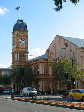
Norwood town hall.jpg
Rathaus von Norwook an The Parade
Staat: Australien Australien
Bundesstaat: Flag of South Australia.svg South Australia
Gegründet: 1847
Koordinaten: 34° 55′ S, 138° 38′ O-34.923138.633Koordinaten: 34° 55′ S, 138° 38′ O
 
Einwohner: 5.704 (2006) [1]
 
Zeitzone: ACST (UTC +9:30)
Postleitzahl: 5067
LGA: Norwood, Payneham & St Peters City
Norwood (Australien)
Norwood
Norwood

Norwood ist ein Stadtteil von Adelaide mit 5700 Einwohnern im australischen Bundesstaat South Australia. Er befindet sich etwa 4 Kilometer östlich des Stadtzentrums und ist Sitz des Verwaltungsgebiet (LGA) Norwood, Payneham & St Peters City. Mit seiner Gründung am 7. Juli 1853 ist es die älteste selbstständige Verwaltungseinheit, außerhalb von Adelaide, in South Australia.[2]

Geschichte

Norwood ist benannt nach Norwood in London. Die ersten Planungen und Landzuweisungen fanden 1847 statt. Anfang der 1850er Jahren begann sich dann eine Gruppe von Leuten für eine gemeinsame Verwaltung der drei Nachbarorte Norwood, Marryatville und Kensington einzusetzen, welche am 7. Juli 1853 daraufhin eingerichtet wurde. 1859 wurde dann das erste Rathaus in South Australia in Norwood eröffnet. In den 1860er Jahren wurde ein Wasser- und Gasnetz eingerichtet und 1878 wurde Norwood durch eine von Pferde gezogenen Straßenbahn, an das Nahverkehrsnetz von Adelaide angebunden. Das alte Rathaus wurde 1883 durch ein neues, zweistöckiges Gebäude ersetzt. Es bildet mit seiner Lage an der wichtigsten Straße von Norwood The Parade noch heute den Mittelpunkt des Stadtteils.[2]

Weblinks

Einzelnachweise

  1. Australian Bureau of Statistics (25. Oktober 2007): Norwood (State Suburb) (Englisch). 2006 Census QuickStats. Abgerufen am 31. Oktober 2011.
  2. a b The History of Kensington & Norwood - The Birth of Local Government, Homepage der City of Norwood Payneham & St Peters. Abgerufen am 1. November 2011.

Wikimedia Foundation.

Игры ⚽ Поможем написать реферат

Schlagen Sie auch in anderen Wörterbüchern nach:

  • Norwood, South Australia — Norwood Adelaide, South Australia The Norwood Town Hall on The Parade Population …   Wikipedia

  • South Australia Police — Infobox Australian police| name = South Australia Police motto = Keeping SA Safe established = 28 April, 1838 commissioner = Commissioner Malcolm Hyde APM ministry = Justice Portfolio headquarters = South Australia Police Headquarters, 30… …   Wikipedia

  • Saint Ignatius College, South Australia — Infobox Secondary school name = Saint Ignatius College motto = Deo Gloria To The Greater Glory Of God established = 13 February 1951 type = Independent secondary affiliations = Roman Catholic, Jesuit headmaster = Fr. Robert Davoren, Junior School …   Wikipedia

  • St. Peters, South Australia — Infobox Australian Place | type = suburb name = St Peters city = Adelaide state = sa caption = lga = City of Norwood Payneham St Peters postcode = 5069 est = 1838 pop = area = propval = $690,000 [cite web… …   Wikipedia

  • Clovelly Park, South Australia — Clovelly Park Adelaide, South Australia English Avenue, looking east towards South Road …   Wikipedia

  • Para Hills, South Australia — Infobox Australian Place | type = suburb name = Para Hills state = sa city = Adelaide caption = A gully next to Para Hills primary school area = 3.21 lga = City of Salisbury lga2 = City of Tea Tree Gully postcode = 5096 pop = 7,722 [Census 2006… …   Wikipedia

  • Stepney, South Australia — Infobox Australian Place | type = suburb name = Stepney city = Adelaide state = sa caption = lga = City of Norwood Payneham St Peters postcode = 5069 est = 1850 pop = 916 (2001 census) area = 0.6 propval = $453,500 (Norwood/St Peters Stepney not… …   Wikipedia

  • Maylands, South Australia — Maylands Adelaide, South Australia Population: 1,424 (2001 census) Established: 1876 Postcode …   Wikipedia

  • Marryatville, South Australia — Marryatville Adelaide, South Australia Population: 618 (2006 census)[1] Postcode: 5068 …   Wikipedia

  • Marden, South Australia — Marden Adelaide, South Australia Population: 1,954 (2006 census)[1] Postcode: 5070 …   Wikipedia

Share the article and excerpts

Direct link
Do a right-click on the link above
and select “Copy Link”