- Ottawa Islands
-
Ottawa Islands Gewässer Hudson Bay Geographische Lage 59° 45′ N, 80° 11′ W59.75-80.183333333333Koordinaten: 59° 45′ N, 80° 11′ W 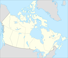

Anzahl der Inseln 9 (+ zahlreiche Felseilande) Hauptinsel Gilmour Island Gesamtfläche ca. 200 km² Einwohner (unbewohnt) Historische Karte der Hudson Bay mit Ottawa Islands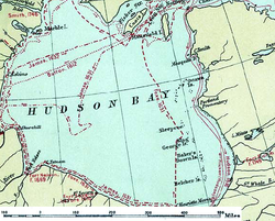
Die Ottawa Islands sind eine Inselgruppe im Osten der Hudson Bay in Kanada, westlich der Labrador-Halbinsel gelegen. Politisch gehören sie zur Region Qikiqtaaluk des Territoriums Nunavut.
Geographie
Die Ottawa Islands liegen rund 100 km vom Pointe aux Ecueils an der Westküste der Ungava-Halbinsel im Norden Labradors entfernt. Zur Mansel-Insel im Norden beträgt die Entfernung rund 175 km, zu den Belcherinseln im Süden etwa 250 Kilometer. Die Inselgruppe besteht aus neun größeren Inseln (principal islands) sowie unzähligen kleinen und kleinsten Inseln und Felsen, die sich von Nordosten nach Südwesten über eine Länge von über 100 Kilometern parallel zur Küste erstrecken. Die neun größten Inseln sind (von Nordost nach Südwest):
- Bronson Island, 5 km²
- Booth Island, 5 km²
- Gilmour Island, 84 km²
- Perley Island, 45 km²
- Pattee Island, 12 km²
- J. Gordon Island
- Eddy Island, 12 km²
- House Island
- Waters Island
Die gesamte Landfläche aller Inseln beträgt rund 200 km². Die kahlen und bergigen Inseln bestehen aus schwarzem Vulkangestein[1] und erreichen im Mount Allan auf Gilmour Island eine Höhe von 344 m über dem Meer.[2]
Literatur
- Manning, T. H. Birds and Mammals of the Belcher, Sleeper, Ottawa and King George Islands, and Northwest Territories. Ottawa: Canadian Wildlife Service, 1976.
Einzelnachweise
- ↑ Sailing directions en route, Pub 146, Sector 15, 2008 (englisch)
- ↑ Ottawa Islands - Topographische Karte von 1976
Kategorien:- Unbewohnte Inselgruppe
- Geographie (Nunavut)
- Inselgruppe (Nordamerika)
- Inselgruppe (Kanada)
- Inselgruppe (Arktischer Ozean)
- Hudson Bay


Wikimedia Foundation.