Otter Island (Alaska)

Otter Island (Alaska)
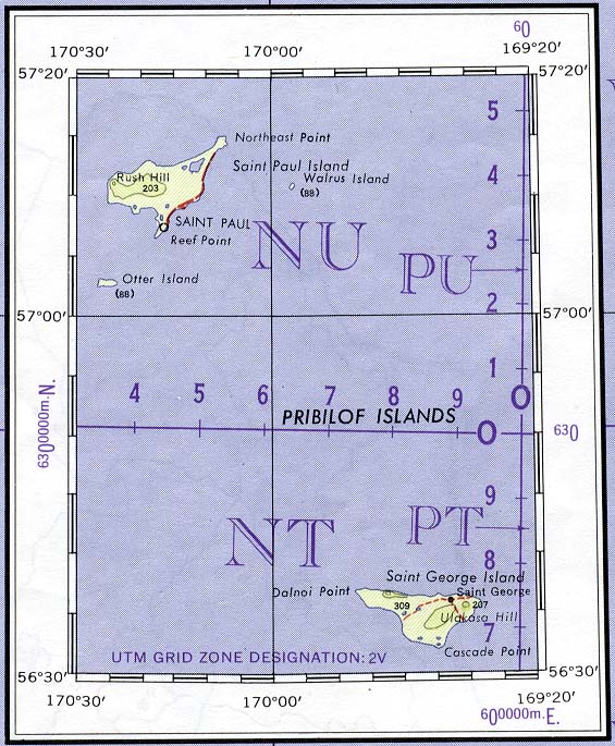
Otter Island
Karte der Pribilof-Inseln
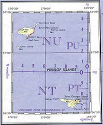
Gewässer Beringmeer
Inselgruppe Pribilof-Inseln
Geographische Lage 57° 2′ 50″ N, 170° 23′ 59″ W57.047222222222-170.39972222222285Koordinaten: 57° 2′ 50″ N, 170° 23′ 59″ W
Otter Island (Alaska)
Otter Island
Fläche 0,67 km²
Höchste Erhebung 285 m
Einwohner (unbewohnt)

Otter Island ist eine kleine Insel aus der Inselgruppe der Pribilof Islands, nördlich der Aleuten im Beringmeer gelegen. Sie gehört administrativ zum US-Bundesstaat Alaska und ist unbewohnt. Die Otterinsel ist 0,67 km² groß. Die höchste Erhebung der Insel liegt 285 Meter über dem Meeresspiegel.


Wikimedia Foundation.

Игры ⚽ Поможем написать курсовую

Schlagen Sie auch in anderen Wörterbüchern nach:

  • Otter Island (Alaska) — Location in Alaska Otte …   Wikipedia

  • Otter Island — ist der Name mehrerer Inseln in den Vereinigten Staaten: Otter Island (Alaska), Alaska Otter Island (Des Moines County, Iowa) Otter Island (Louisa County, Iowa) Otter Island (Kennebec County, Maine) Otter Island (Knox County, Maine) Otter Island… …   Deutsch Wikipedia

  • Otter Island — may refer to: Otter Island, Alaska, island near Saint Paul Island, Alaska Otter Island (Ontario), island in Ontario, Canada Otter Island (South Carolina), noted in American Civil War accounts Otter Island (Wisconsin), island located in Wisconsin …   Wikipedia

  • Nelson Island (Alaska) — Nelson Native name: Qaluyaaq …   Wikipedia

  • Saint Paul Island (Alaska) — Location map Alaska label= lat=57.283333 long= 169.966667 position=right width=250 float=right caption=Location in AlaskaSaint Paul Island is one of the Pribilof Islands, a group of four volcanic islands located in the Bering Sea off the coast of …   Wikipedia

  • Raspberry Island (Alaska) — Raspberry Island is an island of the Kodiak Archipelago located in the Gulf of Alaska in the U.S. state of Alaska. It is located two miles northwest of Whale Island, and just across the mile wide Raspberry Strait from the southwestern end of… …   Wikipedia

  • Pleasant Island (Alaska) — Pleasant Island is the largest island in the Icy Strait between northern Chichagof Island and the mainland of the Alaska Panhandle. It lies southeast of the mainland city of Gustavus and southwest of the mainland community of Excursion Inlet.… …   Wikipedia

  • Alaska Maritime — Karte des AMNWR mit rot gekennzeichneten Schutzgebieten Dreizehenmöwen im Alaska Maritime National Wildlife Refuge …   Deutsch Wikipedia

  • Alaska Maritime National Wildlife Refuge — The Alaska Maritime National Wildlife Refuge (often shortened to Alaska Maritime or AMNWR) is a United States National Wildlife Refuge comprising 2,400 islands, headlands, rocks, islets, spires and reefs in Alaska, with a total area of 4.9… …   Wikipedia

  • Alaska — This article is about the U.S. state of Alaska. For other uses, see Alaska (disambiguation). Alaskan redirects here. For other uses, see Alaskan (disambiguation). State of Alaska …   Wikipedia

Share the article and excerpts

Direct link
Do a right-click on the link above
and select “Copy Link”