- Proclamation Island
-
Proclamation Island Gewässer Südlicher Ozean Geographische Lage 65° 50′ 30″ S, 53° 41′ 0″ O-65.84166666666753.683333333333245Koordinaten: 65° 50′ 30″ S, 53° 41′ 0″ O 

Höchste Erhebung 245 m Einwohner (unbewohnt) Proclamation Island ist eine kleine, felsige Insel vor der Küste des Enderbylands in der Ostantarktis. Sie liegt etwa 2,5 Seemeilen östlich von Cape Batterbee, östlich der Insel liegen die Aagaard Islands.[1]
Inhaltsverzeichnis
Geschichte
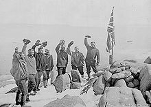 Douglas Mawson und weitere Expeditionsteilnehmer nehmen die Insel für die Krone in Besitz.
Die Insel wurde von der British Australian and New Zealand Antarctic Research Expedition unter Sir Douglas Mawson von Bord der Discovery aus entdeckt. Die Expedition war auf der Suche nach einer möglichen Landestelle an der Küste des Kontinents. Da sich jedoch aufgrund des hohen Eiswalls an der Küste keine solche Stelle fand, wich man auf diese Insel aus. Mit einem Boot ruderten zehn Mann der Expedition am 13. Januar 1930 zur Insel und Mawson betrat als erster den Boden des Eilands. Auf dem 245 m hohen Gipfel der Insel errichteten sie einen Steinhügel für einen Flaggenmast, an dem sie den Union Jack hissten um diese Region des antarktischen Kontinents für die britische Krone in Besitz zu nehmen. Mawson rezitierte zu diesem Anlass eine offizielle Proklamation der Inbesitznahme aus dem Gedächtnis (da das Dokument irrtümlicherweise bereits vorschnell in einem Metallkanister am Flaggemast vergraben worden war). Die Insel erhielt aufgrund dieser Verkündung den Namen Proclamation Island („Proklamations-Insel“).[2]
Einem Vorschlag Australiens folgend wurden der Steinhügel und eine Plakette, die von den Expeditionsmitgliedern dort angebracht worden war, 1972 zur Liste der historischen Stätten und Denkmäler in der Antarktis hinzugefügt.[3]
Fauna
Auf der Insel leben und brüten Pinguine und verschiedene andere Vogelarten. Berichten der British Australian and New Zealand Antarctic Research Expedition und des daran teilnehmenden Ornithologen R. A. Falla zufolge existierten in den 1930er Jahren große Brutkolonien von Adeliepinguinen auf der Insel. Der Forscher J. Cooper, der die Insel 1985 besuchte, fand nur eine Kolonie vor, die er auf eine Größe etwa 5.000 Adeliepinguinen schätzte. Des Weiteren berichtete die Expedition von Schneesturmvögeln (Pagodroma nivea), Weißflügel-Sturmvögeln (Thalassoica antarctica), Kapsturmvögeln (Daption capense), Silbersturmvögeln (Fulmarus glacialoides), Buntfuß-Sturmschwalben (Oceanites oceanicus) und Antarktikskuas (Stercorarius maccormicki).[4]
1978 entdeckte der Forscher D. S. Horning Exemplare der Käferspezies Bountya insularis auf der Insel.[5]
Literatur
- Christy Collis: The Proclamation Island moment: making Antarctica Australian. In Law Text Culture Volume 8, Issue 1. 2004. ISSN 1322-9060, S. 39-56
Einzelnachweise
- ↑ Proclamation Island (Englisch). Geographic Names Information System. United States Geological Survey. Abgerufen am 7. Dezember 2010.
- ↑ Christy Collis: The Proclamation Island moment: making Antarctica Australian. In: Law Text Culture. 8, Nr. 1, 2004, S. 39-56 (http://eprints.qut.edu.au/4585/1/4585_1.pdf, abgerufen am 7. Dezember 2010).
- ↑ Antarctic Treaty Secretariat: List of Historic Sites and Monuments approved by the Antarctic Treaty Consultative Meeting. Abgerufen am 7. Dezember 2010.
- ↑ J. Cooper: Adelie penguins breeding in Eastern Enderby Land, Antarctica. In: Emu. 85, Nr. 3, 1985, S. 205-206, doi:10.1071/MU9850205 (http://www.publish.csiro.au/?act=view_file&file_id=MU9850205.pdf, abgerufen am 7. Dezember 2010).
- ↑ James Ian Townsend: Larva of Bountya insularis Townsend (Coleoptera: Carabidae). In: New Zealand Entomologist. 11, 1988 (http://www.ento.org.nz/nzentomologist/free_issues/NZEnto11_1_1988/Volume%2011-9-11.pdf, abgerufen am 7. Dezember 2010).
Kategorien:- Unbewohnte Insel
- Insel (Antarktika)
- Insel (Südlicher Ozean)

Wikimedia Foundation.