Pyecombe

Pyecombe
Pyecombe
West Sussex UK location map.svg
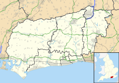
Koordinaten 50° 54′ N, 0° 10′ W50.899444444444-0.16361111111112Koordinaten: 50° 54′ N, 0° 10′ W
Pyecombe (England)
Pyecombe
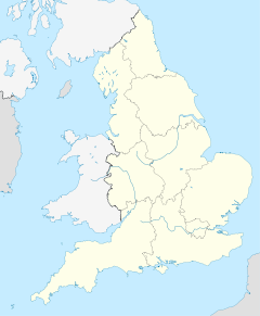
Pyecombe
Bevölkerung 200 (Stand: 2001)
Fläche 8,87 km² (3,42dep1)
Verwaltung
Vorwahl 01273
Landesteil England
Region South East
Shire county West Sussex
District Mid Sussex
Website: http://www.pyecombe.org.uk/

Pyecombe ist ein Dorf im District Mid Sussex in West Sussex, England. Es liegt etwa wenige Kilometer nördlich von Brighton. Laut Volkszählung hatte Pyecombe 2001 insgesamt 200 Einwohner.

Inhaltsverzeichnis

Geografie

Das Dorf liegt an der London to Brighton-Straße.

Geschichte

Der Name „Pyecombe“ leitet sich von „peac cumb“ („Gipfel-Tal“) ab.

Die Pfarrkirche wurde weitgehend im Jahre 1170 gebaut.

Sport

Der Pyecombe Golf Club liegt nördlich des Dorfes.

Außerdem gibt es in Pyecombe die Reitschule The Three Greys und das Gestüt Brendon Stud.

Söhne und Töchter der Stadt

Weblinks


Wikimedia Foundation.

Игры ⚽ Нужен реферат?

Schlagen Sie auch in anderen Wörterbüchern nach:

  • Pyecombe — infobox UK place country = England static static image caption= latitude= 50.89883 longitude= 0.16394 official name = Pyecombe population = civil parish= Pyecombe shire district= Mid Sussex shire county= West Sussex region= South East England… …   Wikipedia

  • Church of the Transfiguration, Pyecombe — Church of the Transfiguration The church from the southeast …   Wikipedia

  • A281 road — UK road routebox road= A281 length mi= length km= direction= Primarily South East North West start= Guildford destinations= Horsham end= Pyecombe construction date= completion date= junctions= ukroadsmall|23 gbroadsmall|24 ukroadsmall|29… …   Wikipedia

  • Mid Sussex — District   Non metropolitan district   Mid Sussex shown within West Sussex Sove …   Wikipedia

  • Brighton — This article is about the town of Brighton in England. For the city, see Brighton and Hove. For other uses, see Brighton (disambiguation). Coordinates: 50°50′35″N 0°07′53″W /  …   Wikipedia

  • London to Brighton events — The route along the A23 (and, often, nearby minor roads) from London to Brighton in south east England is popular for races, tours, charity rides and rallies. The route was originally popularized by the London to Brighton Veteran Car Run begun in …   Wikipedia

  • Cuckfield — Coordinates: 51°00′20″N 0°08′26″W / 51.0055°N 0.1406°W / 51.0055; 0.1406 …   Wikipedia

  • List of civil parishes in West Sussex — This is a list of civil parishes in West Sussex, England. Although now largely unconnected with the ancient ecclesiastical parish, many of them bear the names of the latter, and cover the same area. Some are the result of amalgamations of the… …   Wikipedia

  • List of places in West Sussex — This is a list of cities, towns and villages in the ceremonial county of West Sussex, England. compactTOC NOTOC A*Adversane, Albourne, Aldingbourne, Aldwick, Amberley, Angmering, Ansty, Apuldram, Ardingly, Arundel, Ashington, Ashurst, Ashurst… …   Wikipedia

  • Lindfield, West Sussex — Coordinates: 51°00′49″N 0°05′00″W / 51.0135°N 0.0833°W / 51.0135; 0.0833 …   Wikipedia

Share the article and excerpts

Direct link
Do a right-click on the link above
and select “Copy Link”