- Ramalde
-
Ramalde Wappen Karte 

Basisdaten Region: Norte Unterregion: Grande Porto Distrikt: Porto Concelho: Porto Koordinaten: 41° 10′ N, 8° 39′ W41.168909-8.647479Koordinaten: 41° 10′ N, 8° 39′ W Einwohner: 37.647 (Stand: 2001) Fläche: 5,9 km² Bevölkerungsdichte: 6.381 Einwohner pro km² Politik Webseite: www.jf-ramalde.pt Ramalde ist eine Stadtgemeinde (Freguesia) der nordportugiesischen Stadt Porto.
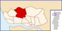 Lage der Gemeinde im Kreis
In ihr leben 37.647 Einwohner (Stand: 2001).[1]
Einzelnachweise
- ↑ Daten zu Ramalde (en). alea.pt. Abgerufen am 6. Mai 2011.
Weblinks
 Commons: Ramalde – Sammlung von Bildern, Videos und Audiodateien
- Karte der Freguesia Ramalde beim Instituto Geográfico do Exército
 Freguesias im Concelho Porto
Aldoar | Bonfim | Campanhã | Cedofeita | Foz do Douro | Lordelo do Ouro | Massarelos | Miragaia | Nevogilde | Paranhos | Ramalde | Santo Ildefonso | São Nicolau | Sé | Vitória
Wikimedia Foundation.
Schlagen Sie auch in anderen Wörterbüchern nach:
Ramalde — Saltar a navegación, búsqueda Ramalde Escudo Concelho Oporto Área 5,68 km² … Wikipedia Español
Ramalde — Infobox Parish pt official name = Ramalde image coat of arms = PRT ramalde.png Municipality = Porto area total = 5.68 population total = 37,647 (2001) population density = 6,628 website = none footnotes =Ramalde (pron. IPA2|ʁɐ maɫd(ɨ)) is a… … Wikipedia
Porto Metro — Info Locale Porto Transit type Light rail Number of … Wikipedia
Metro de Oporto — Metro do Porto Ubicación Gran Oporto … Wikipedia Español
Porto — Oporto redirects here. For other uses of Porto and Oporto, see Porto (disambiguation). Coordinates: 41°9′43.71″N 8°37′19.03″W / 41.1621417°N 8.6219528°W … Wikipedia
Liste Des Stations Du Métro De Porto — Sommaire 1 Historique 2 Ligne A (Bleue) 3 Ligne B (Rouge) 4 Ligne C (Verte) 5 … Wikipédia en Français
Liste des stations du metro de Porto — Liste des stations du métro de Porto Sommaire 1 Historique 2 Ligne A (Bleue) 3 Ligne B (Rouge) 4 Ligne C (Verte) 5 … Wikipédia en Français
Liste des stations du métro de Porto — Sommaire 1 Historique 2 Ligne A (Bleue) 3 Ligne B (Rouge) 4 Ligne C (Verte) 5 Ligne D (Ja … Wikipédia en Français
Liste des stations du métro de porto — Sommaire 1 Historique 2 Ligne A (Bleue) 3 Ligne B (Rouge) 4 Ligne C (Verte) 5 … Wikipédia en Français
Porto — Wappen Karte … Deutsch Wikipedia
Ramalde


18+
© Academic, 2000-2025
- Kontaktieren Sie uns: Unterstützung, Werbung
Wörterbücher Export, schritte mit PHP, Joomla, Drupal, WordPress, MODx.