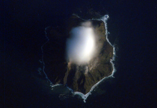
Chirinkotan

Chirinkotan
Tschirinkotan
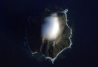
Höhe 724 m
Lage Russland (Kurilen)
Geographische Lage 48° 58′ 49″ N, 153° 29′ 12″ O48.980277777778153.48666666667724Koordinaten: 48° 58′ 49″ N, 153° 29′ 12″ O
Tschirinkotan (Russland)
DEC
Tschirinkotan
Typ Schichtvulkan
Alter des Gesteins 20 Jahre
Letzte Eruption 1986

Tschirinkotan (russisch Остров Чиринкотан; jap. 越渇磨島, Chirinkotan-tō) ist eine vulkanische Insel der russischen Kurilen. Tschirinkotan liegt ca. 30 km westlich von Ekarma, einer weiteren Kurileninsel vulkanischen Ursprungs. Nur ein kleiner Teil des Vulkans (9 km²) liegt außerhalb des Wassers. Der 724 Meter hohe Schichtvulkan brach zuletzt 1986 aus.


Wikimedia Foundation.

Игры ⚽ Нужно решить контрольную?

Schlagen Sie auch in anderen Wörterbüchern nach:

  • Chirinkotan — Native name: Чиринкотан 知林古丹島 NASA picture of Chirinkotan Island …   Wikipedia

  • Chirinkotan — Chirinkotan. Chirinkotan (en ruso, Чиринкотан, y en japonés, Chirinkotan) es una isla rusa en el archipiélago de las Kuriles. Tiene una superficie de 6 km². Pertenece al grupo de las Kuriles septentrionales. Geografía La isla de Chirinkotan se… …   Wikipedia Español

  • Чиринкотан — Чиринкотан …   Википедия

  • Tchirinkotan — Чиринкотан (ru) Image satellite de Tchirinkotan ennuagée. Géographie Pays …   Wikipédia en Français

  • Kuril Islands — Location of Kuril Islands in the Western Pacific. Matua Isl …   Wikipedia

  • Îles Kouriles — Курильские острова (ru) Carte des îles Kouriles. Géographie …   Wikipédia en Français

  • Islas Kuriles — Coordenadas: 50°00′N 155°12′E / 50, 155.2 …   Wikipedia Español

  • Sea of Okhotsk — Coordinates: 55°N 150°E / 55°N 150°E / 55; 150 …   Wikipedia

  • Atlasov Island — For the shield volcano situated in Kamchatka, see Atlasova. Atlasov Alaid …   Wikipedia

  • Onekotan — Native name: Онекотан 温禰古丹島 Onekotan Island (centre) from space, October 1994. North at top …   Wikipedia

Share the article and excerpts

Direct link
Do a right-click on the link above
and select “Copy Link”