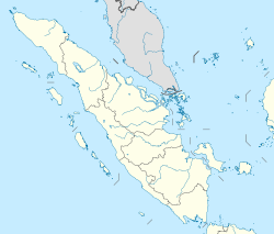
Rangsang

Rangsang

Vorlage:Infobox Insel/Wartung/Bild fehltVorlage:Infobox Insel/Wartung/Höhe fehlt

Rangsang
Gewässer Straße von Malakka
Geographische Lage 1° 1′ N, 102° 56′ O1.0166666666667102.93333333333Koordinaten: 1° 1′ N, 102° 56′ O
Rangsang (Sumatra)
Rangsang
Länge 60 km
Breite 18 km
Fläche 907,7 km²
Einwohner 57.876 (2007)
64 Einw./km²
Hauptort Tanjung Samak / Banto

Rangsang (indonesisch Pulau Rangsang) ist eine indonesische Insel vor der Ostküste von Sumatra in der Straße von Malakka gelegen.

Geografie

Mit einer Fläche von knapp 908 km²[1] stellt sie die fünftgrößte einer ganzen Reihe von vor der Ostküste Sumatras liegenden Inseln dar, die jeweils durch nur wenige Kilometer breite Meeresarme voneinander getrennt sind. Nördlich von Rangsang liegt die Straße von Malakka und südlich von Rangsang die Insel Rantau, von der sie durch die Airhitam Strait getrennt ist. Ebenfalls im Süden, östlich von Rantau, liegen die kleinen Inseln Tupang und Serapung, noch weiter östlich die größere Mendol. Östlich von Rangsang liegen die Inseln Karimun Besar, Karimun und Kundur.

Rangsang ist rund 60 km lang, bis zu 18 km breit und durchweg flach.

Verwaltung

Administrativ gehört die Insel Rangsang zum Regierungsbezirk (Kabupaten) Kepulauan Meranti der Provinz Riau und besteht aus den zwei Unterdistrikten (Kecamatan) Rangsang und Rangsang Barat die zusammen 57.876 Einwohner haben (Stand: 2007). Die beiden Hauptorte sind Tanjung Samak and der Südostküste sowie Banto im Westen der Insel

Einzelnachweise

  1. UNEP Islands (englisch)

Wikimedia Foundation.

Игры ⚽ Поможем сделать НИР

Schlagen Sie auch in anderen Wörterbüchern nach:

  • Rangsang — is an island in the Strait of Malacca, Sumatra, Indonesia. Its area is 908 km². It is just north of Tebing Tinggi Island and just east of Karimun and Kundur islands in Riau Islands. An Indonesian Navy warship is named after the island (KRI Pulau… …   Wikipedia

  • Rangsang — 0°59′36″N 102°53′26″E / 0.99333, 102.89056 Rangsang est une île dans le détroit de Malacca, dans la province indonésienn …   Wikipédia en Français

  • Kepulauan Meranti Regency — Meranti Islands Regency   Regency   Seal …   Wikipedia

  • List of current ships of the Indonesian Navy — All the Navy Vessels are named with the KRI Initial. KRI (Kapal Perang Republik Indonesia) means Navy Vessel Of The Republic Of Indonesia. The class are often named after the lead ships. Naval Jack of Indonesia The navy includes Frigates,… …   Wikipedia

  • Islands of Indonesia — Indonesia comprises 17,508 islands (based from Seminar Nasional Penetapan Nama Pulau pulau Kecil Dalam Presektif Sejarah or National Seminary of Name For Little Islands From History Side , July 16 to 18 at Palembang, South Sumatra, Indonesia, now …   Wikipedia

  • Batavia, Dutch East Indies — Batavia was the name of the capital city of the Netherlands Indies from 1619 to 1942. Its name is now Jakarta, the capital city of the Republic of Indonesia.Before the DutchIn the 15th century AD there was, at the mouth of the Ciliwung River in… …   Wikipedia

  • Mataram Sultanate — This article is about a historic kingdom on Java in what is now Indonesia. For other uses, see Mataram (disambiguation). Nagari Mataram Sultanate of Mataram ← …   Wikipedia

  • Dumai — Seal …   Wikipedia

  • Tebing Tinggi Island — is an island off the northern coast (Strait of Malacca) of Riau Province, Sumatra, Indonesia. Not to be confused with Tebing Tinggi city in North Sumatra. It is directly west of Padang Island and directly south of Rangsang Island …   Wikipedia

  • Riau — Basisdaten Fläche: 72.569 km² Einwohner: 5.543.031 …   Deutsch Wikipedia

Share the article and excerpts

Direct link
Do a right-click on the link above
and select “Copy Link”