San Francisco Mountains (Utah)

San Francisco Mountains (Utah)

p1

San Francisco Mountains
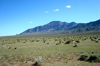
Blick vom Wah Wah Valley zum Frisco Mountain

Blick vom Wah Wah Valley zum Frisco Mountain

Höchster Gipfel Frisco Peak (2.944 m)
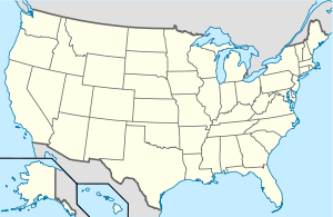
Lage Utah, USA
San Francisco Mountains (USA)
San Francisco Mountains
Koordinaten 38° 32′ N, 113° 16′ W38.533333333333-113.266666666672944Koordinaten: 38° 32′ N, 113° 16′ W

Die San Francisco Mountains sind ein Gebirgszug im Millard und im Beaver County im Bundesstaat Utah.

Der rund 23 Kilometer lange Höhenzug trennt das Wah Wah Valley von den Beaver Bottoms, im Norden setzt er sich östlich des Sevier Lake in den Cricket Mountains fort, im Süden läuft er über die Shauntie Hills in der Escalante Desert aus.

Der Höhenzug besteht größtenteils aus kambrischen Quarziten, daneben sind pennsylvanische Kalksteine und stellenweise Reste vulkanischer Aktivitäten aus dem Tertiär vorhanden. Von historischer Bedeutsamkeit waren Erzvorkommen - hauptsächlich Silber, aber auch Gold, Kupfer, Zink und Blei. Auch heute sind einige Minen aktiv, die Städte Frisco und Newhouse sind aber bereits seit rund 100 Jahren verlassen.

Der höchste Punkt des Gebirges ist der Frisco Peak (2.944 m), er erhebt sich rund 1.300 Meter über das Wah Wah Valley.

Die San Francisco Mountains werden im Süden am Frisco Summit (1.981 m) von der Utah State Route 21 überquert, über eine unbefestigte Straße über den Iron Mine Pass (1.832 m) besteht eine direkte Verbindung von Medford zum Sevier Lake.

Weblinks

Informationen zur Geologie (en.)


Wikimedia Foundation.

Игры ⚽ Нужно сделать НИР?

Schlagen Sie auch in anderen Wörterbüchern nach:

  • San Francisco Maritime National Historical Park — San Francisco Maritime National Historical Park …   Wikipedia

  • San Francisco — • Archdiocese established 29 July 1853 to include multiple counties in the State of California, U.S.A Catholic Encyclopedia. Kevin Knight. 2006. San Francisco     San Francisco      …   Catholic encyclopedia

  • San Francisco National Cemetery — is a U.S. National Cemetery, located in the Presidio of San Francisco, California. Because of the name and location, it is frequently confused with Golden Gate National Cemetery, a few miles south of the city. About 1937, San Francisco residents… …   Wikipedia

  • South San Francisco, California — City of South San Francisco   City   South San Francisco as viewed from a nearby ridge Nickname(s) …   Wikipedia

  • Utah State Route 21 — Karte …   Deutsch Wikipedia

  • San Bernardino, California — San Bernardino redirects here. For other uses, see San Bernardino (disambiguation). City of San Bernardino   City   …   Wikipedia

  • Utah — • The thirty second state admitted to the Union, takes its name from an Indian tribe known as the Utes Catholic Encyclopedia. Kevin Knight. 2006. Utah     Utah      …   Catholic encyclopedia

  • Utah War — Date March 1857 July 1858 Location Utah, Wyoming Result Brigham Young replaced as governor of the territory. A full pardon for charges of sedition and treason issued to the ci …   Wikipedia

  • San Antonio Missions National Historical Park — IUCN Category V (Protected Landscape/Seascape) …   Wikipedia

  • San Gabriel Valley Council — Owner Boy Scouts of America Headquarters …   Wikipedia

Share the article and excerpts

Direct link
Do a right-click on the link above
and select “Copy Link”