Selwyn Lake

Selwyn Lake
Selwyn Lake

Photo-request.svg

Bild gesucht 

BW

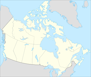
Geographische Lage Nordwest-Territorien, Saskatchewan (Kanada)
Abfluss Chipman River
Daten
Koordinaten 60° 5′ 0″ N, 104° 25′ 2″ W60.083333333333-104.41722222222398Koordinaten: 60° 5′ 0″ N, 104° 25′ 2″ W
Selwyn Lake (Kanada)
Selwyn Lake
Höhe über Meeresspiegel 398 m
Fläche 593 km²[1]

Selwyn Lake ist ein See an der Grenze zwischen den Nordwest-Territorien und der Provinz Saskatchewan in Kanada. Die Wasserfläche beträgt 593 km², die Gesamtfläche einschließlich Inseln 717 km².[1] Er liegt auf einer Höhe von 398 m. Der See wird über den Chipman River zum 50 km südlich gelegenen Black Lake entwässert. Zum nördlich gelegenen See Wholdaia Lake, der im Einzugsgebiet der Hudson Bay liegt, führt eine Portage-Verbindung.

Einzelnachweise

  1. a b Natural Resources Canada - The Atlas of Canada - Lakes

Wikimedia Foundation.

Игры ⚽ Поможем написать реферат

Schlagen Sie auch in anderen Wörterbüchern nach:

  • Selwyn Lake — Sp Sèlvino ẽžeras Ap Selwyn Lake L Kanadoje (Saskačevano p ja, ŠV teritorijos) …   Pasaulio vietovardžiai. Internetinė duomenų bazė

  • Lake Coleridge — Location Selwyn District, Canterbury Region, South Island Coordinates …   Wikipedia

  • Lake Ellesmere — Sonnenuntergang am Lake Ellesmere Geographische Lage Selwyn Distrikt, Canterbury (Neuseeland)/Christchurch, Neuseeland …   Deutsch Wikipedia

  • Selwyn Dewdney — Selwyn Hanington Dewdney (October 9, 1909 ndash;November 18, 1979) was an author, illustrator, artist, activist and pioneer in both art therapy and pictography. Early life He was born in Prince Albert, Saskatchewan on October 9, 1909 and was the… …   Wikipedia

  • Selwyn Snowfields — Selwyn Snowfields. Selwyn Snowfields ist ein kleines Skigebiet in den nördlichen Snowy Mountains im Kosciuszko National Park in New South Wales, Australien. Das Skigebiet liegt unweit von Adaminaby, Kiandra und Cabramurra, dem höchstgelegenen Ort …   Deutsch Wikipedia

  • Lake Chemong — J. A. Gifford Causeway with Bridgenorth on opposite shore Location Ontario Group Kawartha lakes …   Wikipedia

  • Lake Chemong — Geographische Lage Ontario (Kanada) Zuflüsse Trent Severn Waterway …   Deutsch Wikipedia

  • Lake Ellesmere — Infobox lake lake name = Lake Ellesmere Te Waihora image lake = caption lake = image bathymetry = caption bathymetry = location = Selwyn District and Christchurch City, Canterbury Region, South Island coords = coord|43|48|S|172|25|E|region:NZ… …   Wikipedia

  • Selwyn District — The Selwyn district is a predominantly rural area in central Canterbury, on the east coast of New Zealand s South Island. It is named after the Selwyn River, which is in turn named after Bishop Selwyn, an early explorer of the area. Local… …   Wikipedia

  • Selwyn River — The Selwyn River/Waikirikiri is located in the Selwyn District of Canterbury in the South Island of New Zealand. [ [http://www.linz.govt.nz/apps/placenames/index.html?p=125774 Selwyn River/Waikirikiri] , New Zealand Geographic Placenames Database …   Wikipedia

Share the article and excerpts

Direct link
Do a right-click on the link above
and select “Copy Link”