Lake Chemong

Lake Chemong
Lake Chemong
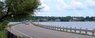
Lake Chemong - Bridgenorth ON.JPG
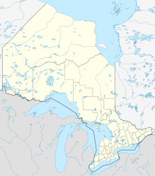
Geographische Lage Ontario (Kanada)
Zuflüsse Trent-Severn Waterway
Abfluss Trent-Severn Waterway
Orte in der Nähe Peterborough
Daten
Koordinaten 44° 24′ N, 78° 23′ W44.4-78.383333Koordinaten: 44° 24′ N, 78° 23′ W
Lake Chemong (Ontario)
Lake Chemong
Länge 14 kmf6
Breite 1 kmf7

Der Lake Chemong oder Chemong Lake ist ein See in der kanadischen Provinz Ontario. Er liegt 8 km nordwestlich von Peterborough in der Nähe der Stadt Bridgenorth.

Er liegt 8 km nordwestlich von Peterborough. Gemeinden am und in der Nähe des Sees sind Bridgenorth und Selwyn im Osten und Ennismore Township im Westen. Der James-A.-Giffort-Damm überquert den See und verbindet Bridgenorth und Ennismore per Straße.

Der See ist 14 km lang und 1 km breit. Der Lake Chemong bildet zusammen mit dem Buckhorn Lake und dem Pigeon Lake eine Dreier-Seengruppe, die zu den Kawartha Lakes gehört. Der Trent-Severn Waterway, ein Kanal, der die Georgsbucht mit dem Ontariosee verbindet, führt durch den See. Auf dem See liegen einige kleine Inseln, darunter auch Big Island, was übersetzt „Große Insel“ bedeutet.

Am Ufer des Sees befinden sich viele Cottages und Campingplätze. Auf dem See werden viele Fischerturniere ausgetragen, die gewöhnlichsten Fische sind Schwarzbarsch, Forellenbarsch und Muskellunge.

Obwohl der See im allgemeinen Chemong heißt, ist die offizielle Orthographie Chemung aufgrund einer Bitte einer Indianergemeinde. Chemong bedeutet übersetzt Schlamm, was auf die Sumpfgebiete in der Umgebung des Sees zurückzuführen ist.


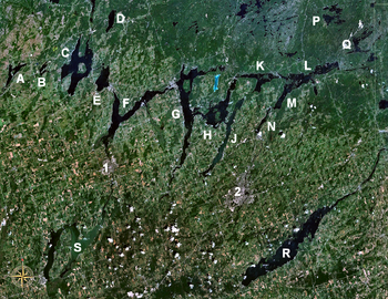
Die Kawartha Lakes, Lake Chemong als J abgebildet

Wikimedia Foundation.

Игры ⚽ Нужно сделать НИР?

Schlagen Sie auch in anderen Wörterbüchern nach:

  • Lake Chemong — J. A. Gifford Causeway with Bridgenorth on opposite shore Location Ontario Group Kawartha lakes …   Wikipedia

  • Curve Lake First Nation 35, Ontario — Coordinates: 44°27′33″N 78°22′16″W / 44.459113°N 78.371058°W / 44.459113; 78.371058 …   Wikipedia

  • Bridgenorth, Ontario — Bridgenorth is a community that is part of Smith Ennismore Lakefield, Ontario, previously Smith Township. It sits on the eastern shore of Lake Chemong. It is located north of Peterborough, east of Lindsay, south of Buckhorn and west of Lakefield …   Wikipedia

  • Big Island — The term Big Island can be:In CanadaPlaces* Big Island, Ontario, the name of a place in Ontario, CanadaIslands* Big Island in Nunavut ** Big Island (Kimmirut), the largest of the three ** Big Island (Hudson Bay) ** Big Island (James Bay) * Big… …   Wikipedia

  • List of lakes in Ontario — This is an incomplete list of lakes in Ontario, a province of Canada.A*Lake Abitibi *Agnew Lake *Ahmic Lake *Allumette Lake *Arrowhead Lake *Astrolabe Lake *Attawapiskat LakeB*Balsam Lake *Bamaji Lake *Bark Lake *Bass Lake *Belwood Lake *Lake… …   Wikipedia

  • Liste der Seen in Kanada — Diese Liste enthält die 69 vom kanadischen Umweltministerium Natural Resources Canada als hauptsächliche Seen in Kanada bezeichneten Gewässer, die größer als 400 km² sind. Name Höhe Fläche Provinz Koordinaten Smallwood Reservoir 471 6527… …   Deutsch Wikipedia

  • List of islands of Ontario — This is a list of islands of Ontario.Lake Abitibi*Black Island *Kenosha Island *Mistaken Islands =Balsam Lake= *Grand IslandBig Rideau Lake*Grindstone IslandBuckhorn Lake*Emerald Isle *Fox Island *Nichol IslandCataraqui River*Isle of… …   Wikipedia

  • Kawartha Lakes — Die Kawartha Lakes Die Kawartha Lakes sind eine Seengruppe in Ontario, Kanada. Zu ihnen gehören die Seen nördlich des Ontario und östlich des Simcoesees Die Stadt Kawartha Lakes wurde nach den Seen benannt. Sie befindet sich im Westen der… …   Deutsch Wikipedia

  • Big Island — ist der Name folgender Orte in dem Vereinigten Staaten: Big Island (Baldwin County, Alabama) Big Island (Mobile County, Alabama) Big Island (Craighead County, Arkansas) Big Island (Greene County, Arkansas) Big Island (Mississippi County,… …   Deutsch Wikipedia

  • Ennismore Township, Ontario — Ennismore Township is a geographic township and former municipality located in Peterborough County, Ontario, Canada. The Township, located approx. 20 km north of Peterborough, was first surveyed in 1823. Farming is the primary industry with… …   Wikipedia

Share the article and excerpts

Direct link
Do a right-click on the link above
and select “Copy Link”