Sibuyan

Sibuyan

Vorlage:Infobox Insel/Wartung/Bild fehlt

Sibuyan
Gewässer Sibuyan-See
Inselgruppe Philippinen
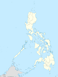
Geographische Lage 12° 25′ N, 122° 35′ O12.416666666667122.583333333332057Koordinaten: 12° 25′ N, 122° 35′ O
Sibuyan (Philippinen)
Sibuyan
Länge 30 km
Breite 20 km
Fläche 465 km²
Höchste Erhebung Sibuyan
2.057 m
Einwohner 56.541 (2007)
122 Einw./km²
Hauptort Taclobo

Sibuyan ist eine Insel in der gleichnamigen Sibuyan-See. Sie gehört zu den Philippinen und dort zur Provinz Romblon.

Inhaltsverzeichnis

Geografie

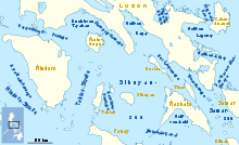
Die Insel Sibuyan inmitten der Sibuyan-See

Die Insel hat eine Fläche von 465 km² [1], nach anderen Angaben 499 km². Zwei Berge dominieren die Topographie der Insel, der Guiting-Guiting mit 2058 m und der Sibuyan mit 2050 m über dem Meer. Im westlichen Teil der Insel liegt der Mount Nailog. 6 km im Westen liegt die Insel Romblon, im Osten Masbate und im Süden Panay.

Ein Drittel der Inselfläche nimmt mit 157 km² der Mount Guiting-guiting Natural Park ein.

Verwaltung

Die Insel gliedert sich in die drei Gemeinden Cajidiocan (Nordosten), Magdiwang (Nordwesten) und San Fernando (Süden).[2] Die einzelnen Gemeinden haben eine Fläche von: Cajidiocan (201,85 km²), Magdiwang (100,75 km²), San Fernando (223,35 km²). Die Insel hatte am 1. August 2007 eine Bevölkerung von 56541 Personen. Größter Ort ist Taclobo an der Südküste in der Gemeinde San Fernando, mit einer Bevölkerung von 4097 zur Volkszählung 2000.[3]

Weblinks

Referenzen

  1. http://islands.unep.ch/IHE.htm#879
  2. Liste der Gemeinden
  3. Zensus 2000

Wikimedia Foundation.

Игры ⚽ Нужно решить контрольную?

Schlagen Sie auch in anderen Wörterbüchern nach:

  • Sibuyan — Géographie Pays  Philippines Archipel Visayas Localisation …   Wikipédia en Français

  • Sibuyan — Sibuyan, Insel, zur Gruppe der Bissayer (s.d. d) gehörig …   Pierer's Universal-Lexikon

  • Sibuyan Island — Infobox Islands name = Sibuyan image caption = Map of the Romblon showing the location of the municiplaity of San Fernando on the island. locator Location map|Philippines|lat=12.433333|long=122.55|width=175|float=center map custom = yes native… …   Wikipedia

  • Sibuyan-See — Die Sibuyan See ist ein zentral zwischen den philippinischen Inseln im Bezirk MIMARO gelegenes Binnenmeer. Sie wird manchmal auch Sibu See abgekürzt. Die mittleren Philippinen mit der Sibuyan See …   Deutsch Wikipedia

  • Sibuyan Sea — The Sibuyan Sea is a small sea in the Philippines that separates the Visayas from the northern Philippine island of Luzon. It is bounded by the island of Panay to the south, Mindoro to the west, and to the north the Bicol Peninsula of Luzon… …   Wikipedia

  • Sibuyan Sea — geographical name body of water central Philippines bounded by Mindoro, S Luzon, & the Visayan Islands …   New Collegiate Dictionary

  • Mar de Sibuyan — (Sibuyan Sea) Bahia de Romblón, en la isla homónima Ubicación geográfica …   Wikipedia Español

  • Mer de Sibuyan — Carte de la mer de Sibuyan. Géographie humaine Pays côtier(s) …   Wikipédia en Français

  • Mer De Sibuyan — La mer de Sibuyan au centre de la carte Type Mer intérieure Localisation Océan Pacifique Pays côtier(s) …   Wikipédia en Français

  • Mer de sibuyan — La mer de Sibuyan au centre de la carte Type Mer intérieure Localisation Océan Pacifique Pays côtier(s) …   Wikipédia en Français

Share the article and excerpts

Direct link
Do a right-click on the link above
and select “Copy Link”