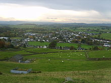
Staveley (Kendal)

Staveley (Kendal)
54.37562-2.81894
Staveley

Staveley ist ein Ort am Eingang zu Kentmere Tal in der Nähe von Kendal in Cumbria, England. Der Ort gehörte bis 1974 zu Lancashire und kam durch den Local Government Act zu Cumbria.

Erste Siedlungsspuren in Staveley sind aus der Zeit um 4000 v. Chr. überliefert. Die A591 folgt heute dem Verlauf einer römischen Straße von Kendal nach Ambleside durch Staveley. Der Ort hat einen Bahnhof an der Kendal and Windermere Railway.

Staveley erhielt 1328 das Marktrecht und hielt seit dem wöchentlich einen Markt ab. 1338 erhielt der Ort das Recht eine der Heiligen Margareta geweihte Kirche zubauen, die 1388 fertiggestellt wurde. Von der Kirche steht heute nur noch der Turm. Die heutige Pfarrkirche St.James stammt aus dem Jahr 1864.

Heute gibt es in Staveley keine nennswerte Industrie mehr, der Ort war einst als Produzent von hölzernen Spindeln für die Spinnereien Lancashires bekannt. Die Drechsler nutzten das Wasser der Flüsse Gowan und Kent, die sich in Staveley treffen für ihre Maschinen.

Quellen


Wikimedia Foundation.

Игры ⚽ Нужно сделать НИР?

Schlagen Sie auch in anderen Wörterbüchern nach:

  • Staveley, Cumbria — Staveley (gbmapping|SD469981) is a village in Cumbria some 4 miles north west of Kendal, situated at the mouth of the Kentmere valley.GeographyTraditionally in the county of Westmorland, it became part of the new non metropolitan county of… …   Wikipedia

  • Staveley — ist der Name folgender Ort in England: Staveley bei Kendal in Cumbria Staveley in Cartmel in Cumbria Staveley in Derbyshire Staveley in North Yorkshire Diese Seite ist …   Deutsch Wikipedia

  • Kendal and Windermere Railway — Bahnhof Windermere Kendal and Windermere Railway heute Windermere Branch Line Legende …   Deutsch Wikipedia

  • Kentmere — Coordinates: 54°25′44″N 2°50′24″W / 54.429°N 2.840°W / 54.429; 2.840 …   Wikipedia

  • Civil parishes in Cumbria — A map of Cumbria, showing the districts: (1) Barrow in Furness; (2) South Lakeland; (3) Copeland; (4) Allerdale; (5) Eden; and (6) Carlisle. A civil parish is a subnational entity, forming the lowest unit of local government in England. There are …   Wikipedia

  • River Kent — Geobox|River name = Kent native name = other name = other name1 = image size = 300 image caption = River Kent in Kendal country = England country1 = state = state1 = region = region1 = district = district1 = city = city1 = length = 32 watershed …   Wikipedia

  • Cumbria — Not to be confused with Cumbia, Umbria, or Cambria. Cumbria …   Wikipedia

  • South Lakeland — Infobox UK District name = South Lakeland District status = District region = North West England admincounty = Cumbria area = Ranked 6th 1,553.39 km² adminhq = Kendal onscode = 16UG population = Ranked English district rank|ONS=16UG English… …   Wikipedia

  • Westmorland and Lonsdale (UK Parliament constituency) — UK constituency infobox Name = Westmorland and Lonsdale Map1 = WestmorlandLonsdale Map2 = Cumbria Type = County Year = 1983 Entity = Cumbria County = Cumbria EP = North West England MP = Tim Farron Party = Liberal DemocratWestmorland and Lonsdale …   Wikipedia

  • Lake District — The Skiddaw massif, town of Keswick and Derwent Water seen from Walla Crag …   Wikipedia

Share the article and excerpts

Direct link
Do a right-click on the link above
and select “Copy Link”