Trembleur Lake

Trembleur Lake
Trembleur Lake

Photo-request.svg

Bild gesucht 

BW

Geographische Lage British Columbia (Kanada)
Zuflüsse Middle River
Abfluss Tachie River
Orte am Ufer Middle River (British Columbia)
Orte in der Nähe Fort St. James
Daten
Koordinaten 54° 49′ 0″ N, 125° 9′ 0″ W54.816666666667-125.15Koordinaten: 54° 49′ 0″ N, 125° 9′ 0″ W
Trembleur Lake (British Columbia)
Trembleur Lake

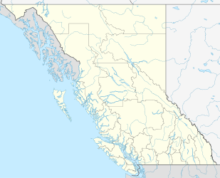
Trembleur Lake (Dakelh: Dzindlat Bun) ist ein See in der kanadischen Provinz British Columbia. Der See ist knapp 50 km lang. Er gehört zu den „Nechako-Seen“, einer Seengruppe im British Columbia Interior. Der See wird vom Middle River gespeist, welcher den Takla Lake als Ursprung hat. Der Abfluss des Sees bildet der Tachie River, welcher zum südlich gelegenen Stuart Lake fließt. Dieser wird über Stuart River, Nechako River und Fraser River entwässert. Trembleur Lake liegt auf der Strecke, welche alljährlich von Rotlachsen und Königslachsen auf der Wanderung zu ihren Laichgründen zurückgelegt wird.

Am Nordufer des Trembleur Lake liegt der kleine Trembleur Lake Provincial Park, welcher Sandstrände und Ankerstellen umfasst, sonst aber keine Infrastruktur bietet. Der 412,33 km² große Rubyrock Lake Provincial Park umfasst das Westende des Trembleur Lake und reicht im Süden bis zum Cunningham Lake und dem Stuart Lake.

Weblinks


Wikimedia Foundation.

Игры ⚽ Нужно сделать НИР?

Schlagen Sie auch in anderen Wörterbüchern nach:

  • Trembleur Lake Provincial Park — is a provincial park in British Columbia, Canada …   Wikipedia

  • Middle River (Trembleur Lake) — Middle River Dzitl ainli KohVorlage:Infobox Fluss/GKZ fehlt Lage British Columbia (Kanada) Flusssystem Fraser River Abfluss über Trembleur Lake → …   Deutsch Wikipedia

  • Stuart Lake — Infobox lake lake name = Stuart Lake image lake = caption lake = image bathymetry = caption bathymetry = location = British Columbia coords = coord|54|33|N|124|35|W|region:CA BC type:waterbody|display=inline,title type = inflow = outflow =… …   Wikipedia

  • Stuart Lake — Bild gesucht  BW Geographische Lage British Columbia (Kanada) Zuflüsse …   Deutsch Wikipedia

  • Carrier language — Carrier Dakeł (ᑕᗸᒡ) Spoken in Canada Region Central Interior of British Columbia Ethnicity Carrier people Nati …   Wikipedia

  • Omineca Gold Rush — The Omineca Gold Rush was a gold rush in British Columbia, Canada in the Omineca region of the Northern Interior of the province. Gold was first discovered there in 1861, but the rush didn t begin until late in 1869 with the discovery at Vital… …   Wikipedia

  • Tl'azt'en Nation — is an Indian band located along the north shore of Stuart Lake in the northern interior of British Columbia. The two main villages belonging to Tl azt en Nation are Tache (often spelled Tachie in English), 60km northwest of Fort St. James and… …   Wikipedia

  • Carrier people — The Dakelh (pronounced [tákʰɛɬ]) or Carrier are the indigenous people of a large portion of the Central Interior of British Columbia, Canada. Most Carrier call themselves Dakelh, meaning people who go around by boat . The term Carrier is a… …   Wikipedia

  • Tachie River — Tachie RiverVorlage:Infobox Fluss/GKZ fehlt Lage British Columbia (Kanada) Flusssystem Fraser River Abfluss über Stuart Lake → Stuart River → …   Deutsch Wikipedia

  • Middle River (British Columbia) — The Middle River, or in the Carrier language (Dakelh) Dzitl ainli Koh,[1] is a river in the Omineca Country of the northwestern Central Interior of British Columbia, Canada, flowing southeast from the outlet of Takla Lake into Trembleur Lake[2]… …   Wikipedia

Share the article and excerpts

Direct link
Do a right-click on the link above
and select “Copy Link”