Unga Island

Unga Island

Vorlage:Infobox Insel/Wartung/Höhe fehlt

Unga Island
Küste von Unga Island
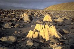
Gewässer Golf von Alaska
Inselgruppe Shumagin Islands
Geographische Lage 55° 15′ 38″ N, 160° 41′ 42″ W55.260556-160.695Koordinaten: 55° 15′ 38″ N, 160° 41′ 42″ W
Unga Island (Alaska)
Unga Island
Fläche 442 km²
Einwohner (unbewohnt)

Unga Island ist die größte Insel der der Alaska-Halbinsel vorgelagerten Shumagin Islands im Golf von Alaska.

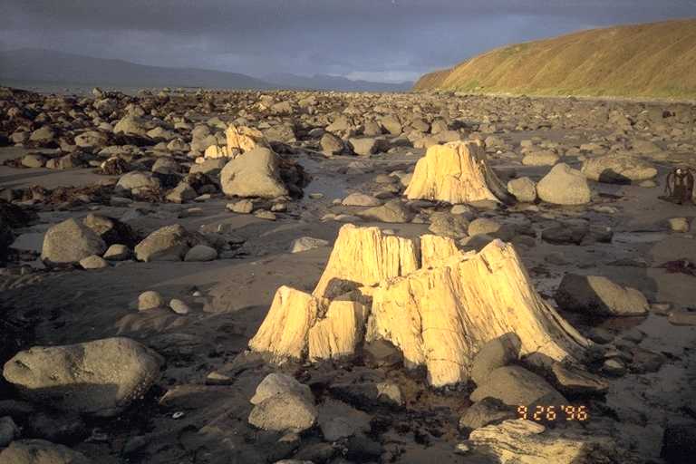
Unga Island wurde 1968 als National Natural Landmark ausgewiesen. Versteinerte Bäume an der Küste der Insel sind Überreste von Urwelt- und Küstenmammutbäumen, die im Tertiär von vulkanischer Asche begraben wurden. Sie sind von wissenschaftliche Bedeutung wegen ihrer Aussagekraft bezüglich der Wanderungen über die Landbrücke Beringia zwischen Asien und Nordamerika und das Klima im Aleutenbogen vor der menschlichen Besiedlung Alaskas. [1]

Die Bezeichnung der Aleuten für die Insel wurde 1827 von Adam Johann von Krusenstern von der kaiserlich-russischen Armee als „Ounga“ aufgezeichnet. Von Innokenti Weniaminow (1797–1879), einem russisch-orthodoxen Priester, der die aleutische Bevölkerung missionierte, wurde 1840 der Name „O(strov) Unga“ dokumentiert.

Einzelnachweise

  1. National Natural Landmark: Unga Island auf nps.gov

Weblinks


Wikimedia Foundation.

Игры ⚽ Поможем написать курсовую

Schlagen Sie auch in anderen Wörterbüchern nach:

  • Unga Island — (Uĝnaasaqax̂ [Bergsland, K Aleut Dictionary Fairbanks: Alaska Native Language Center, 1994] in Aleut) is the largest of the Shumagin Islands off the Alaska Peninsula in southwestern Alaska, USA. The island has a land area of 170.73 sq mi (442.188 …   Wikipedia

  • Unga — may refer to:*Unga Group, a flour milling company in Kenya ndash; derived from the Swahili word for corn/wheat flour * A native name for the Coconut crab * An alternate term for Ounceland, a Scottish measurement. * UNGA, an abbreviation for… …   Wikipedia

  • Unga — steht für: United Nations General Assembly, Englisch für die Generalversammlung der Vereinten Nationen Unga Island, eine Insel im Golf von Alaska Unga (Tom), einen Nebenfluss des Tom in Russland Unga (Ziwil), einen Nebenfluss des Ziwil in… …   Deutsch Wikipedia

  • Unga, Alaska — Coordinates: 55°11′03″N 160°30′18″W / 55.18417°N 160.505°W / 55.18417; 160.505 Unga is a ghost town on U …   Wikipedia

  • Korovin Island — (Tanĝanuk [Bergsland, K Aleut Dictionary Fairbanks: Alaska Native Language Center, 1994] in Aleut) is one of the Shumagin Islands in the Gulf of Alaska south of the Alaska Peninsula in the Aleutians East Borough of Alaska, USA. The island lies… …   Wikipedia

  • Mo'unga'one — is an island in Lifuka district, in the Haªapai islands of Tonga. It had a population of 136 (in 2006) and an area of 1.17 km2 (0.45 sq mi).[1] See also List of cities in Tonga References ^ GeoHive Tonga …   Wikipedia

  • Liste der National Natural Landmarks in Alaska — Die Liste der National Natural Landmarks in Alaska führt alle geologischen und ökologischen Objekte im US amerikanischen Bundesstaat Alaska auf, die zu National Natural Landmarks erklärt wurden. National Natural Landmarks Name Bild Datum der… …   Deutsch Wikipedia

  • Evstratii Delarov — Evstratii Ivanovich Delarov (also spelled Evstrat Delarov and Eustrate Delarof, c. 1740 – 1806) was a Greek born mariner who served with several Russian maritime fur trade companies in Russian America. He was the first documented Greek explorer… …   Wikipedia

  • Flagstaff Hill, Alaska — Infobox Mountain Name = Flagstaff Hill Photo = Caption = Elevation = convert|3|ft|m|0|lk=on Location = Unga Island, Alaska, United States Range = Prominence = Coordinates = coord|55|10|53|N|160|30|26|W|type:mountain region:US|display=inline,title …   Wikipedia

  • Shumagin Islands — Big Koniuji Island, eine Insel der Shumagin Islands Gewässer Golf von …   Deutsch Wikipedia

Share the article and excerpts

Direct link
Do a right-click on the link above
and select “Copy Link”