Upernivik

Upernivik
Upernivik
Luftbild vom Südwesten Uperniviks
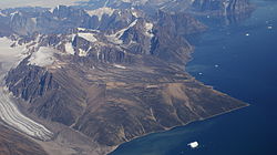
Gewässer Uummannaq-Fjord/ Baffin Bay
Geographische Lage 71° 16′ N, 52° 45′ W71.266666666667-52.752105Koordinaten: 71° 16′ N, 52° 45′ W
Upernivik (Grönland)
Upernivik
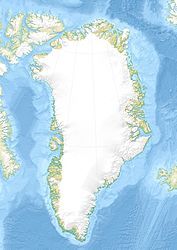
Länge 30 km
Breite 23,2 km
Fläche 540 km²
Höchste Erhebung Palup Qaqqaa
2.105 m
Einwohner (unbewohnt)
Lage von Upernivik im Uummannaq Fjord

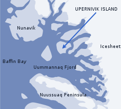
Upernivik (dänisch Upernivik Ø) ist eine unbewohnte, gebirgige Insel im Uummannaq-Fjord im Westen Grönlands. Höchster Punkt der 540 km²[1] großen Insel, 2105 m über dem Meeresspiegel gelegen, ist der Palup Qaqqaa.[2] Administrativ gehört die Insel zur Großkommune Qaasuitsup.

Die Insel ist vom grönländischen Festland durch die Meeresstraßen Inukavsait im Norden (2,6 km breit bis zur Halbinsel Akuliaruseq) und Paakassaa (3,8 km breit).

Siehe auch

Einzelnachweise

  1. Gazetteer of Greenland - Islands (englisch)
  2. Palup Qaqqaa bei Peakbagger.com (englisch)

Wikimedia Foundation.

Игры ⚽ Нужно сделать НИР?

Schlagen Sie auch in anderen Wörterbüchern nach:

  • Upernivik — Upernivik, nördlichste dän. Kolonie in Grönland, unter 72°48 nördl. Br., auf einer Insel an der Westküste, mit Missionsanstalt und (1900) 83 Einw. Der gleichnamige Distrikt zählt 878 Einw …   Meyers Großes Konversations-Lexikon

  • Upernivik — Upernivik, nördlichster dän. Distrikt Grönlands, (1901) ca. 960 E.; die Missionsstation U. auf einer Insel …   Kleines Konversations-Lexikon

  • Upernivik Island — is an island in Kitaa county, West Greenland. Its area is 540 km2. It is mountainous (highest point: Palup Qaqa, 2105 m.) …   Wikipedia

  • Isla Upernivik — Upernivik Ø Localización País  Dinamarca Territorio Groenlandia …   Wikipedia Español

  • Упернивик — (Upernivik) самый сев. округ Гренландии. Главный город его, с миссионерским училищем, лежит на о ве Баффинова залива под 72°48 сев. шир …   Энциклопедический словарь Ф.А. Брокгауза и И.А. Ефрона

  • Grönland — Grönland, großes, hauptsächlich unter dän. Landeshoheit stehendes Nordpolarland, trennt die europäischen Eismeere (Dänemarkstraße und Grimlandsee) von den amerikanischen (Davisstraße, Baffinbai, Smithsund, Kennedy und Robesonkanal); s. Karte… …   Meyers Großes Konversations-Lexikon

  • Pre-Columbian Discovery of America —     Pre Columbian Discovery of America     † Catholic Encyclopedia ► Pre Columbian Discovery of America     Of all the alleged discoveries of America before the time of Columbus, only the bold voyages of exploration of the fearless Vikings to… …   Catholic encyclopedia

  • Ludvig Mylius-Erichsen — (January 15 1872 November 25 1907) was a Danish author, ethnologist, and explorer, from Ringkøbing. He was most notably an explorer of Greenland. With Count Harald Moltke and Knud Rasmussen he formed the Danish Literary expedition (1902 04) to… …   Wikipedia

  • Edward Augustus Inglefield — Edward Inglefield Edward Augustus Inglefield (* 27. März 1820 in Cheltenham; † 5. September 1894 in London) war ein englischer Admiral und Polarforscher …   Deutsch Wikipedia

  • Les Aventures Du Capitaine Hatteras — Couverture originale Auteur Jules Verne Genre Roman d aventures Pays d orig …   Wikipédia en Français

Share the article and excerpts

Direct link
Do a right-click on the link above
and select “Copy Link”