Wairoa River (Bay of Plenty)
- Wairoa River (Bay of Plenty)
-

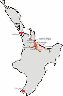
Lage der Kaimai Ranges auf der Nordinsel und Tauranga
Wairoa ist ein Fluss in Neuseeland.
Neben ihm gibt es noch weitere Flüsse mit diesem Namen in Neuseeland, da in der Sprache der Maori Wairoa der Begriff für langes Wasser ist.
Der Wairoa fließt nordwärts in den Hafen von Tauranga am westlichen Ende der Bay of Plenty auf der Nordinsel Neuseelands. Der Fluss speist sich aus einem größeren Einzugsgebiet in den Kaimai Ranges.
Es gibt am Wairoa River mehrere Staudämme zur Gewinnung von Elektroenergie. Der letzte Damm führt das Wasser durch die Ruahine Power Station (Ruahine Wasserkraftanlage). Ein Arrangement mit den Nutzern einer Wildwasser-Anlage gewährleistet, dass an 26 Tagen im Jahr das Wasser frei durch das Flussbett fließen kann. Dadurch können mehrere Wildwasser-Rennen veranstaltet werden. Die Wildwasser-Rennen starten bei den Mc-Clarens-Fällen, einem 25-Fuß-Wasserfall, den einige Kajakfahrer gelegentlich auch befahren, der Hauptteil der Nutzer startet jedoch unterhalb davon. Jedes Jahr im Februar ist der obere Abschnitt des Flusses die Heimat von Wildwasser-Kajak-Rennen.
Wikimedia Foundation.
Schlagen Sie auch in anderen Wörterbüchern nach:
Wairoa River, Bay of Plenty — For other New Zealand rivers called Wairoa, see Wairoa River. For the smaller watercourse on Motiti island, Bay of Plenty, see Wairoa Stream. The Wairoa River runs north into Tauranga Harbour at the western end of the Bay of Plenty in New Zealand … Wikipedia
Mangapapa River (Bay of Plenty) — Mangapapa River Origin Kaimai Range Mouth Lake McLaren Basin countries New Zealand Mouth elevation 81 metres (266 ft) The Mangapapa River is a river of the Bay of Plenty Region of New Zealand s … Wikipedia
Wairoa River — ist der Name von folgenden Flüssen in Neuseeland: Wairoa River (Northland) Wairoa River (Hawke’s Bay) Wairoa River (Bay of Plenty) Wairoa River (Clevedon) Wairoa River (Tasman) Ein sehr kleiner Wairoa River auf Motiti Island in der Bay of Plenty … Deutsch Wikipedia
Wairoa River — Wairoa is the name of several rivers and streams in New Zealand. Wairoa is Māori for long water .* Wairoa River, Northland * Wairoa River, Hawke s Bay * Wairoa River, Tasman * Wairoa River, Bay of Plenty * Wairoa River, Auckland * Wairoa Stream,… … Wikipedia
Wairoa (Bay of Plenty Region) — Lage der Kaimai Ranges auf der Nordinsel und Tauranga Wairoa ist ein Fluss in Neuseeland. Neben ihm gibt es noch weitere Flüsse mit diesem Namen in Neuseeland, da in der Sprache der Maori Wairoa der Begriff für langes Wasser ist. Der Wairoa… … Deutsch Wikipedia
Bay of Plenty — The Bay of Plenty ( mi. Te Moana a Toi), often abbreviated to BoP, is a region in the North Island of New Zealand situated around the body of water of the same name. The bay was named by James Cook after he noticed the abundant food supplies at… … Wikipedia
Hawke's Bay — Hawke’s Bay Karte Basisdaten Hauptstadt: Napier … Deutsch Wikipedia
Mangakarengorengo River — Mouth Wairoa River Basin countries New Zealand The Mangakarengorengo River is a river of the Bay of Plenty Region of New Zealand. It is a tributary of the Wairoa River. See also List of rivers of New Zealand … Wikipedia
Omanawa River — Mouth Wairoa River Basin countries New Zealand Length 25 kilometres (16 mi) The Omanawa River is a river of the Bay of Plenty Region of New Zealand s North Island. It flows north from the northern edge of the Mamaku Plateau, reaching the … Wikipedia
Opuiaki River — Origin Mamaku Plateau Mouth Wairoa River Basin countries New Zealand Length 24 kilometres (15 mi) The Opuiaki River is a river of the Bay of Plenty Region of New Zealand … Wikipedia

