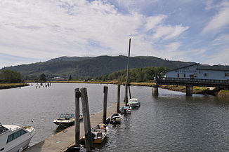
Willapa River

Willapa River
Willapa River
Willapa River bei Raymond

Willapa River bei RaymondVorlage:Infobox Fluss/KARTE_fehlt

Daten
Gewässerkennzahl US1509528
Lage Washington, Vereinigte Staaten
Flusssystem Willapa River
Ursprung Blaney Creek
46° 29′ 50″ N, 123° 24′ 47″ W46.4973259-123.4129257
Vorlage:Infobox Fluss/QUELLHÖHE_fehlt
Mündung bei South Bend in die Willapa Bay
46.7075982-123.85044210

46° 42′ 27″ N, 123° 51′ 2″ W46.7075982-123.85044210
Mündungshöhe mVorlage:Infobox Fluss/NACHWEISE_fehlenVorlage:Infobox Fluss/HÖHENUNTERSCHIED_fehlt
Länge 32 kmVorlage:Infobox Fluss/NACHWEISE_fehlen
Einzugsgebiet 674 km²[1]
Abflussmenge
am Pegel bei Willapa[2]
NNQ: 790 l/s (im Jahr 1970)
MQ: 1,44 m³/s
HHQ: 6,43 m³/s (im Jahr 2007)
Kleinstädte Raymond (Washington), South Bend

Der Willapa River ist ein Fluss im Pacific County im Südwesten des US-Bundesstaats Washington. Er entspringt etwa 40 km westlich von Chehalis in den Willapa Hills. Er fließt nordwestlich und entwässert ein meist hügeliges Gebiet nördlich des Columbia River, bis er nach etwa 32 km bei South Bend in die Willapa Bay, einem großen Ästuar an der Pazikküste mündet.

Der Fluss ist benannt nach den Willapa, einem Athabaskischsprachigen Indianerstamm, der das Flusstal und die Region bis zu den Quellbächen des Chehalis und des Cowlitz River besiedelte[3].

Weblinks

Einzelnachweise

  1. EPA: Washington - Willapa River. Abgerufen am 23. Juli 2011.
  2. USGS Real Time Water Data: Willapa River. Abgerufen am 23. Juli 2011.
  3. Curtis, Edward S.: The North American Indian. Volume 9 - The Salishan tribes of the coast. The Chimakum and the Quilliute. The Willapa. Seattle 1913, S. 154

Wikimedia Foundation.

Игры ⚽ Поможем решить контрольную работу

Schlagen Sie auch in anderen Wörterbüchern nach:

  • Willapa River — The Willapa River is a river on the Pacific coast of southwestern Washington in the United States, approximately 20 mi (32 km) long. It drains an area of low hills and a coastal plain into Willapa Bay, a large estuary north of the mouth of the… …   Wikipedia

  • Willapa Bay — is a bay located on the southwest Pacific coast of Washington state in the United States. The Long Beach Peninsula separates Willapa Bay from the greater expanse of the Pacific Ocean. Willapa Bay is fairly shallow: more than half of its surface… …   Wikipedia

  • Willapa Hills — p1 Willapa Hills Willapa Bay mit Willapa Hills im Hintergrund Höchster Gipfel Boistfort Peak (941 m …   Deutsch Wikipedia

  • Willapa Bay — Die Willapa Bay ist eine Bucht im Pacific County des US Bundesstaates Washington. Sie ist etwa 38 km lang und etwa 17 km breit und wird durch die Long Beach Peninsula vom Pazifik abgetrennt. In der Bucht liegen die Inseln Long Island… …   Deutsch Wikipedia

  • Naselle River — Coordinates: 46°27′54″N 123°56′24″W / 46.465°N 123.94°W / 46.465; 123.94 …   Wikipedia

  • Steamboats of Willapa Bay — Willapa Bay is a large shallow body of water near the Pacific Ocean in southwestern Washington. For a number of years before modern roads were built in Pacific County, Washington, the bay was used as the means of travel around the county, by… …   Wikipedia

  • North River (Washington) — The North River before emptying into Willapa Bay. The North River is a river, approximately 30 miles (48 km) long, in western Washington, in the United States. It empties into Willapa Bay, the first large estuary on the Washington coast… …   Wikipedia

  • Niawiakum River — Coordinates: 46°37′48″N 123°56′3″W / 46.63°N 123.93417°W / 46.63; 123.93417 …   Wikipedia

  • Chehalis River (Washington) — Chehalis River Chehalis River Valley (links), Grays Harbor (Bildmitte) und Satsop River Valley (Bildvordergrund)Vorlage:Infobox Fluss …   Deutsch Wikipedia

  • Chehalis River (Washington) — For other places with the same name, see Chehalis River (disambiguation). Coordinates: 46°57′29″N 123°50′5″W / 46.95806°N 123.83472°W / …   Wikipedia

Share the article and excerpts

Direct link
Do a right-click on the link above
and select “Copy Link”