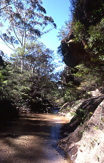
Wollangambe River

Wollangambe River
Wollangambe River
Wollangambe River

Wollangambe RiverVorlage:Infobox Fluss/KARTE_fehlt

DatenVorlage:Infobox Fluss/GKZ_fehlt
Lage New South Wales (Australien)
Flusssystem Hawkesbury RiverVorlage:Infobox Fluss/FLUSSSYSTEM_falsch
Abfluss über Colo River → Hawkesbury River → Tasmansee
Quelle bei Newnes Junction (östlich von Lithgow)
33° 27′ 54″ S, 150° 16′ 21″ O-33.465150.2725924
Quellhöhe 924 mVorlage:Infobox Fluss/HÖHENBEZUG-QUELLE_fehlt[1]
Mündung Colo River im Wollemi-Nationalpark
-33.351666666667150.5805555555654.7

33° 21′ 6″ S, 150° 34′ 50″ O-33.351666666667150.5805555555654.7
Mündungshöhe 54,7 mVorlage:Infobox Fluss/HÖHENBEZUG-MÜNDUNG fehlt[1]
Höhenunterschied 869,3 m
Länge 57,4 km[1]Vorlage:Infobox Fluss/EINZUGSGEBIET_fehlt

Vorlage:Infobox Fluss/ABFLUSS_fehlt

Rechte Nebenflüsse Bell Creek, Bowens Creek
Linke Nebenflüsse Bungleboori Creek, Nayock Creek

Der Wollangambe River ist ein Fluss im Osten des australischen Bundesstaates New South Wales.

Er entspringt bei Newes Junction, einer Kleinstadt östlich von Lithgow in der Südwestecke des Wollemi-Nationalparks. Der Fluss fließt zunächst nach Nordosten bis nördlich der Kleinstadt Mount Irvine. Dort wendet er seinen Lauf nach Norden und nach ca. 20 km wieder nach Nordosten. Im Zentrum des Nationalparks mündet er in den Colo River. Das Flusstal ist größtenteils unbesiedelt und nicht durch Straßen erschlossen.

Seine wichtigsten Nebenflüsse sind der Bowens Creek und der Bungleboori Creek.

Einzelnachweise

  1. a b c Map of Wollangambe River, NSW. Bonzle.com

Wikimedia Foundation.

Игры ⚽ Поможем решить контрольную работу

Schlagen Sie auch in anderen Wörterbüchern nach:

  • Colo River — Der Colo River bei Niedrigwasser bei Upper ColoVorlage:Infobox Fluss/KARTE fehlt …   Deutsch Wikipedia

  • Colo River — The Colo River is a river in New South Wales, Australia. The Colo River begins at the confluence of the Wolgan River and the Capertee River, which respectively drain the Wolgan and Capertee Valleys north of Lithgow. The river flows eastwards and… …   Wikipedia

  • Bell, New South Wales — Bell is a small residential area in the Blue Mountains, 87 km west of Sydney, Australia, some 30 km east of Lithgow and 20 km north of Mount Victoria. It is a locality on the junction of the Bell s Line of Road, and the Darling Causeway. Bell is… …   Wikipedia

  • Liste der Flüsse in Australien — Die Liste der Flüsse in Australien gibt eine Übersicht über alle Flüsse im Staat Australien einschließlich Tasmanien: Inhaltsverzeichnis A B C D E F G H I J K L M N O P Q R S T U V W X Y …   Deutsch Wikipedia

  • Blue Mountains National Park — Infobox protected area of Australia | name = Blue Mountains National Park iucn category = II caption = locator x = 253 locator y = 168 nearest town or city = Katoomba coordinates = coord|33|58|04|S|150|18|15|E|type:landmark region:AU area = 2,482 …   Wikipedia

  • Mount Wilson, New South Wales — Mount Wilson New South Wales Mount Wilson in Autumn Population: 218 (2006 Census) …   Wikipedia

  • Cook County, New South Wales — Map of all coordinates from Google Map of all coordinates from Bing Export all coordinates as KML …   Wikipedia

  • List of rivers of Australia — This is a list of rivers of Australia. Rivers are ordered alphabetically, by state. The same river may be found in more than one state as many rivers cross state borders. QueenslandA * Albert B * Barwon * Balonne * Barcoo * Barron * Bloomfield *… …   Wikipedia

Share the article and excerpts

Direct link
Do a right-click on the link above
and select “Copy Link”