- Wollomombi River
-
Wollomombi River 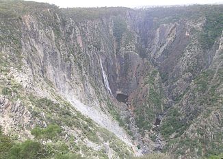
Mündung des Wollomombi River (links) in den Chandler River
Daten Lage New South Wales, Australien Flusssystem Macleay River Abfluss über Chandler River → Macleay River → Tasmansee Quelle Chandlers Peak (bei Guyra)
30° 15′ 57″ S, 151° 46′ 49″ O-30.265833333333151.780277777781280Quellhöhe 1.280 m[1] Mündung Chandler River am Nordende des Oxley-Wild-Rivers-Nationalparks -30.533333333333152.03861111111677Koordinaten: 30° 32′ 0″ S, 152° 2′ 19″ O
30° 32′ 0″ S, 152° 2′ 19″ O-30.533333333333152.03861111111677Mündungshöhe 677 m[1] Höhenunterschied 603 m Länge 65,2 km[1] Linke Nebenflüsse Boundary Creek Kleinstädte Wollomombi Der Wollomombi River ist ein Fluss im Nordosten des australischen Bundesstaates New South Wales.
Inhaltsverzeichnis
Geografie
Der Fluss entspringt an den Osthängen des Chandlers Peak in der Great Dividing Range, ca. 17 km südöstlich von Guyra Er fließt dann in südlicher Richtung durch das nördliche Tafelland von New South Wales in die Kleinstadt Wollomombi. Von dort stürzt der Fluss über die Wollomombi Falls, die etwas westlich der Chandler Falls liegen. Etwas weiter mündet der Wollomombi River an der Nordspitze des Oxley-Wild-Rivers-Nationalparks in den Chandler River.
Nebenflüsse[1] mit Mündungshöhen
- Boundary Creek – 1020 m
Geschichte
Früher hieß der Fluss Wollomombi Creek oder Rockvale Creek.
Im Dezember 1904 ertranken Nellie Gardiner (18 Jahre) und Fanny Kennedy (12 Jahre) beim Bad im Wollomombi River. Eine andere Dame, Mrs. Snipe, ertrank beinahe ebenfalls, als sie die beiden retten wollte.[2]
Landwirtschaft
Am Oberlauf des Flusses werden Kälber und Schafe gezüchtet.
Wanderwege
Vom Aussichtspunkt Wollomombi Falls aus gibt es schöne Wanderwege entlang der Schluchtabstürze von Wollomombi River und Chandler River. Ein steiler Wanderweg führt auch zum Chandler River hinunter.
Weblinks
Bushwalking in Oxley Wild Rivers National Park. WalksAustralia.com
Quelle
Einzelnachweise
Kategorien:- Flusssystem Macleay River
- Fluss in New South Wales
- Fluss in Australien und Ozeanien

Wikimedia Foundation.