Yoboki

Yoboki
Yoboki
Yoboki (Dschibuti)
Yoboki
Yoboki
Basisdaten
Staat Dschibuti
Region Dikhil
ISO 3166-2 DJ-DI
11.51666666666742.1

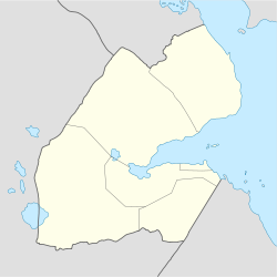
Yoboki (Afar Yōbóki) ist ein kleiner Ort in der Region Dikhil in Dschibuti. Er liegt in der Hanle-Ebene.

Die Bewohner sind größtenteils Afar. 1958 wurde unter der damaligen französischen Kolonialverwaltung eine Schule für Nomaden eröffnet.

Quellen

  • Didier Morin: Dikhil, in: Dictionnaire historique afar (1288-1982), Karthala Editions 2004, ISBN 9782845864924
  • Virginia Thompson, Richard Adloff: Djibouti and the Horn of Africa, Stanford University Press 1968, ISBN 9780804706506 (S. 47, 147, 160)

Wikimedia Foundation.

Игры ⚽ Нужно решить контрольную?

Schlagen Sie auch in anderen Wörterbüchern nach:

  • Yoboki — Infobox Settlement official name = PAGENAME native name = imagesize = image caption = image map caption = pushpin pushpin label position =bottom pushpin mapsize = 300 pushpin map caption =Location in Djibouti subdivision type = Country… …   Wikipedia

  • Yoboki — 11°31′N 42°06′E / 11.517, 42.1 Yoboki …   Wikipédia en Français

  • Yoboki National Park — Infobox protected area | name = Yoboki National Park iucn category = II caption = locator x = locator y = location = flag|Djibouti nearest city = long degrees = long minutes = long seconds = long direction = lat degrees = lat minutes = lat… …   Wikipedia

  • Galafi — Infobox Settlement official name = PAGENAME native name = imagesize = image caption = image map caption = pushpin pushpin label position =bottom pushpin mapsize = 300 pushpin map caption =Location in Djibouti subdivision type = Country… …   Wikipedia

  • List of cities in Djibouti — This is a list of cities in Djibouti ordered by population. All settlements with a population over 1,000 are included.Other cities*Balho *Khor Angar *Yoboki …   Wikipedia

  • Dikhil Region — Country  Djibouti …   Wikipedia

  • List of national parks in Africa — Namib Naukluft National Park in Namibia. This is a list of national parks in Africa. The nature of the parks varies considerably not only between countries but also within some nations – the degree of protection, accessibility and type of… …   Wikipedia

  • Districts of Djibouti — Djibouti …   Wikipedia

  • Airolaf — Infobox Settlement official name = Airolaf native name = imagesize = image caption = image map caption = pushpin pushpin label position =bottom pushpin mapsize = 300 pushpin map caption =Location in Djibouti subdivision type = Country subdivision …   Wikipedia

  • Day Forest National Park — IUCN Category II (National Park) Location  Djibout …   Wikipedia

Share the article and excerpts

Direct link
Do a right-click on the link above
and select “Copy Link”