Clarence Valley Council

Clarence Valley Council
Clarence Valley
Australia-Map-NSW-LGA-ClarenceValley.png
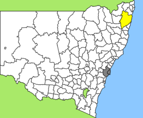
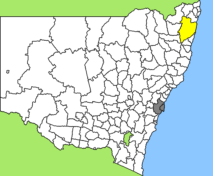
Lage des Clarence Valley Council in New South Wales
Gliederung
Staat: Australien Australien
Bundesstaat: 27px New South Wales
Verwaltungssitz: Grafton
Daten und Zahlen
Fläche: 10.441 km²
Einwohner: 48.146 (2006) [1]
Bevölkerungsdichte: 4,6 Einwohner je km²
-29.683333333333152.93333333333

Clarence Valley Council ist ein lokales Verwaltungsgebiet (LGA) im australischen Bundesstaat New South Wales. Das Gebiet ist 10.441 km² groß und hat etwa 48.000 Einwohner.

Clarence Valley liegt an der Nordküste des Staates etwa 620 km nördlich der Metropole Sydney und 320 km südlich von Brisbane. Das Gebiet umfasst 171 Ortsteile und Ortschaften, darunter Angourie, Brooms Head, Copmanhurst, Coutts Crossing, Diggers Camp, Glenreagh, Grafton, Illuka, Junction Hill, Maclean, Minnie Water, Nymboida, Sandon, Tucabia, Tyndale, Ulmarra, Wooli, Wooloweyah, Woombah, Yamba. Der Verwaltungssitz des Councils befindet sich in der Stadt Grafton im Zentrum der LGA, wo etwa 17.500 Einwohner leben.

Verwaltung

Der Council von Clarence Valley hat neun Mitglieder, die von den Bewohnern der LGA gewählt werden. Clarence Valley ist nicht in Bezirke untergliedert. Aus dem Kreis der Councillor rekrutiert sich auch der Mayor (Bürgermeister) des Councils.

Weblinks

Einzelnachweise

  1. Australian Bureau of Statistics (25. Oktober 2007): Clarence Valley (A) (Local Government Area) (Englisch). 2006 Census QuickStats. Abgerufen am 6. April 2010.

Wikimedia Foundation.

Игры ⚽ Нужна курсовая?

Schlagen Sie auch in anderen Wörterbüchern nach:

  • Clarence Valley Council — Clarence Valley New South Wales Location in New South Wales Population …   Wikipedia

  • Clarence Valley Regional Airport — IATA: GFN – ICAO: YGFN Summary Airport type Public Operator Clarence Valley Council Location …   Wikipedia

  • Richmond Valley Council — Infobox Australian Place | type = lga name = Richmond Valley state = nsw caption = Location in New South Wales pop = formatnum:21313 pop footnotes = [census 2006 AUS|id=LGA16610|name=Richmond Valley (A) (Local Government… …   Wikipedia

  • Clarence County — Map of all coordinates from Google Map of all coordinates from Bing Export all coordinates as KML …   Wikipedia

  • Electoral district of Clarence — Clarence is an electoral district of the Legislative Assembly in the Australian state of New South Wales. It is represented by Steve Cansdell of the National Party of Australia.The 2004 redistribution of electoral districts estimated that the… …   Wikipedia

  • Clarence Johnson — Clarence Leonard Kelly Johnson (February 27, 1910 – December 21, 1990) was an aircraft engineer and aeronautical innovator. As a member and first team leader of the Lockheed Skunk Works, Johnson worked for more than four decades and is said to… …   Wikipedia

  • Clarence, New York — Coordinates: 42°58′36″N 78°35′31″W / 42.97667°N 78.59194°W / 42.97667; 78.59194 …   Wikipedia

  • Clarence E. Coe — Coe Clarence Elliot[1] Coe (1873–1943), known as Clarence E. Coe, was one of the first settlers and farmers in Palms, California, and a member of the Los Angeles Police Commission from 1929 to 1931 and of the Los Angeles City Council from 1931 to …   Wikipedia

  • Clarence Fault — Map of the Marlborough Fault System The Clarence Fault is an active dextral (right lateral) strike slip fault in the northeastern part of South Island, New Zealand. It forms part of the Marlborough Fault System, which accommodates the transfer of …   Wikipedia

  • City of Clarence — Tasmania The City of Clarence Population: 52,935 …   Wikipedia

Share the article and excerpts

Direct link
Do a right-click on the link above
and select “Copy Link”