Colindale (London Underground)
- Colindale (London Underground)
-
Colindale ist eine oberirdische Station der London Underground im Stadtbezirk London Borough of Barnet. Sie liegt in der Travelcard-Tarifzone 4 an der Colindale Avenue. Im Jahr 2007 nutzten 3,790 Millionen Fahrgäste diese von der Northern Line bediente Station.[1]
Die Station wurde am 18. August 1924 eröffnet, zusammen mit der Verlängerung von Hendon Central nach Edgware. Ein Fliegerangriff zerstörte 1940 das ursprüngliche, von Stanley Heaps entworfene Stationsgebäude. Daraufhin wurde es durch ein aus Holz bestehendes Provisorium ersetzt. Das heutige Gebäude stammt aus dem Jahr 1962.
In der Nähe befinden sich das Royal Air Force Museum und das Peel Centre, das Trainingszentrum der Metropolitan Police.
Einzelnachweise
- ↑ London Underground performance update
Weblinks
51.595555555556-0.25
Kategorien:
- Station der London Underground
- Verkehr (London Borough of Barnet)
Wikimedia Foundation.
Schlagen Sie auch in anderen Wörterbüchern nach:
Colindale tube station — Colindale Colindale Tube Station, 8 July 2008 … Wikipedia
Liste der Stationen der London Underground — Dies ist die Liste der Stationen der London Underground, der U Bahn der britischen Hauptstadt London. Enthalten sind alle Stationen, die zurzeit in Betrieb sind oder sich im Bau befinden, ebenso Stationen, die vorübergehend wegen Bauarbeiten… … Deutsch Wikipedia
Burnt Oak (London Underground) — Stationsgebäude der Bahnsteig … Deutsch Wikipedia
Hendon Central (London Underground) — Stationsgebäude Hendon Central ist eine oberirdische Station der London Underground im Stadtbezirk London Borough of Barnet. Sie liegt an der Grenze der Travelcard Tarifzonen 3 und 4, an der Kreuzung von Hendon Way, Watford Way und Queen’s Road.… … Deutsch Wikipedia
London Borough of Barnet — Infobox London Borough | name = London Borough of Barnet motto = short name = Barnet adminhq = North London Business Park imagename = status = London borough | area rank = 255th area km2 = 86.74 ons code = 00AC | url = http://www.barnet.gov.uk/… … Wikipedia
London Plan — For other uses, see London Plan (disambiguation). The geographical scope of the plan is the London region. The London Plan is a planning document written by the Mayor of London, England in the United Kingdom and published by the Greater London… … Wikipedia
List of terrorist incidents in London — London bombings can refer to various bomb attacks and other politically driven violent incidents in London, England:1800s*Fenian attacks ** In 1867 a bomb planted by Fenians at New Prison in Clerkenwell exploded, killing several passers by. [… … Wikipedia
North and West London Light Railway — North and West London Light Railway Geographical map of possible NWLLR stations, on the London Underground tube map Location London, UK Proposer Campaign for Better Transport … Wikipedia
City and South London Railway — A picture of a City South London Railway train from the Illustrated London News, 1890 The City and South London Railway (C SLR) was the first deep level underground tube railway in the world,[1][note 1 … Wikipedia
Edgware, Highgate and London Railway — Route of Edgware, Highgate London Railway highlighted on a 1900 map The Edgware, Highgate and London Railway was a railway in north London. The railway was a precursor of parts of London Underground s Northern Line and was, in the 1930s the core… … Wikipedia
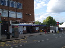 Eingang zur Station
 Commons: Colindale (London Underground) – Sammlung von Bildern, Videos und Audiodateien
