Croaghaun

Croaghaun
Klippen von Croaghaun
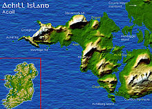
3-D-Karte
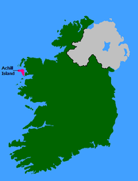
Lage von Achill Island

Croaghaun (irisch: Cruachán) ist ein Berg auf Achill Island im County Mayo in Irland, dessen nördliche Ausläufer mit 664 Metern zugleich die höchsten Klippen Europas bilden.

Croaghaun befindet sich auf dem westlichsten Teil von Achill Island.

53.977777777778-10.194444444444664

Wikimedia Foundation.

Игры ⚽ Нужно сделать НИР?

Schlagen Sie auch in anderen Wörterbüchern nach:

  • Croaghaun — Elevation 688 m (2,257 ft) [1] …   Wikipedia

  • Croaghaun, County Wexford — Croaghaun Stua an Charraig Dubh Elevation 455 m (1,493 ft) Prominence …   Wikipedia

  • Achill Island — Achill Native name: Acaill, Oileán Acla View of the Island using NASA s technology overhead …   Wikipedia

  • Acaill — Lage von Achill Island. Die Insel Achill Island (irisch Acaill; Oileán Acla) liegt in der Grafschaft Mayo und ist mit 146 km² die größte Insel Irlands. Auf Achill Island leben 2.620 Menschen (Stand: 2006). Rund 87 Prozent der Insel sind von… …   Deutsch Wikipedia

  • Achillinsel — Lage von Achill Island. Die Insel Achill Island (irisch Acaill; Oileán Acla) liegt in der Grafschaft Mayo und ist mit 146 km² die größte Insel Irlands. Auf Achill Island leben 2.620 Menschen (Stand: 2006). Rund 87 Prozent der Insel sind von… …   Deutsch Wikipedia

  • Klippen von Moher — Lage und Umgebung der Klippen Die Cliffs of Moher (irisch Aillte an Mhothair = Klippen der Ruine) sind die bekanntesten Steilklippen Irlands. Sie liegen an der Südwestküste Irlands im County Clare nahe der Ortschaften Doolin (nördlich der… …   Deutsch Wikipedia

  • Île d'Achill — Achill Acaill (ga) Vue satellite (NASA) de l île Géographie Pays …   Wikipédia en Français

  • County Mayo — For other uses, see Mayo (disambiguation). County Mayo Contae Mhaigh Eo Coat of arms …   Wikipedia

  • Ireland — This article is about the island. For the sovereign state of the same name, see Republic of Ireland. For the constituent country of the United Kingdom, see Northern Ireland. For other uses, see Ireland (disambiguation). Coordinates …   Wikipedia

  • St Kilda, Scotland — Infobox Scottish island latitude=57.8 longitude= 8.6 GridReference=NF095995 celtic name=Hiort norse name=Possibly Skildir meaning of name= Unknown, possibly Gaelic for westland area= 854.6 ha area rank= highest elevation= Conachair 430 m… …   Wikipedia

Share the article and excerpts

Direct link
Do a right-click on the link above
and select “Copy Link”