- Damelevières
-
Damelevières 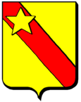
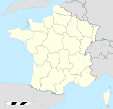

Region Lothringen Département Meurthe-et-Moselle Arrondissement Lunéville Kanton Bayon Gemeindeverband Communauté de communes du val de Meurthe Koordinaten 48° 33′ N, 6° 23′ O48.5569444444446.3880555555556216Koordinaten: 48° 33′ N, 6° 23′ O Höhe 216 m (207–264 m) Fläche 8,12 km² Einwohner 3.016 (1. Jan. 2008) Bevölkerungsdichte 371 Einw./km² Postleitzahl 54360 INSEE-Code 54152 Damelevières ist eine französische Gemeinde mit 3016 Einwohnern (Stand 1. Januar 2008) im Département Meurthe-et-Moselle in der Region Lothringen; sie gehört zum Arrondissement Lunéville und zum Kanton Bayon.
Geografie
Die Gemeinde Damelevières liegt an der Meurthe, sieben Kilometer südwestlich von Lunéville und etwa 20 Kilometer südöstlich von Nancy.
Bevölkerungsentwicklung
Jahr 1962 1968 1975 1982 1990 1999 2007 Einwohner 3254 3194 3021 3039 2879 2810 3012 Barbonville | Bayon | Blainville-sur-l’Eau | Borville | Brémoncourt | Charmois | Clayeures | Damelevières | Domptail-en-l’Air | Einvaux | Froville | Haigneville | Haussonville | Landécourt | Lorey | Loromontzey | Méhoncourt | Romain | Rozelieures | Saint-Boingt | Saint-Germain | Saint-Mard | Saint-Rémy-aux-Bois | Velle-sur-Moselle | Vigneulles | Villacourt | Virecourt

Wikimedia Foundation.