- Delfin Albano
-
Municipality of Delfin Albano (Magsaysay) Lage von Delfin Albano (Magsaysay) in der Provinz Isabela Basisdaten Bezirk: Cagayan Valley Provinz: Isabela Barangays: 29 Distrikt: 1. Distrikt von Isabela PSGC: 023118000 Einkommensklasse: 4. Einkommensklasse Haushalte: 4825 Zensus 1. Mai 2000Einwohnerzahl: 24.899 Zensus 1. August 2007Koordinaten: 17° 19′ N, 121° 47′ O17.316666666667121.78333333333Koordinaten: 17° 19′ N, 121° 47′ O Offizielle Webpräsenz: www.delfinalbano-isabela.gov.ph Geographische Lage auf den Philippinen Delfin Albano (Magsaysay) ist eine Stadtgemeinde in der Provinz Isabela im Bezirk Cagayan Valley auf der philippinischen Insel Luzón. Im Jahre 2000 hatte sie 23.619 Einwohner und 4825 Haushalte.
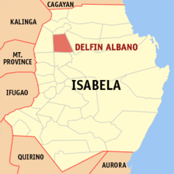
Delfin Albano ist politisch in 29 Baranggays unterteilt:
- Aga
- Andarayan
- Aneg
- Bayabo
- Calinaoan Sur
- Capitol
- Carmencita
- Concepcion
- Maui
- Quibal
- Ragan Almacen
- Ragan Norte
- Ragan Sur (Pob.)
- Rizal (Ragan Almacen Alto)
- San Andres
- San Antonio
- San Isidro
- San Jose
- San Juan
- San Macario
- San Nicolas (Fusi)
- San Patricio
- San Roque
- Santo Rosario
- Santor
- Villa Luz
- Villa Pereda
- Visitacion
- Caloocan
Städte und Stadtgemeinden in der Provinz IsabelaStädte: Cauayan City
Stadtgemeinden: Alicia | Angadanan | Aurora | Benito Soliven | Burgos | Cabagan | Cabatuan | Cordon | Delfin Albano | Dinapigue | Divilacan | Echague | Gamu | Ilagan | Jones | Luna | Maconacon | Mallig | Naguilian | Palanan | Quezon | Quirino | Ramon | Reina Mercedes | Roxas | San Agustin | San Guillermo | San Isidro | San Manuel | San Mariano | San Mateo | San Pablo | Santa Maria | Santo Tomas | Tumauini
Wikimedia Foundation.
Schlagen Sie auch in anderen Wörterbüchern nach:
Delfin Albano, Isabela — Delfin Albano Municipality Map of Isabela showing the location of Delfin Albano … Wikipedia
Quezon, Isabela — Infobox Philippine municipality infoboxtitle = Municipality of Quezon sealfile = Quezon isabela.png locatormapfile = Ph locator isabela quezon.png| caption = Map of Isabela showing the location of Quezon. region = Cagayan Valley (Region II)… … Wikipedia
PH-ISA — Karte der Provinz Isabela Isabela ist eine philippinische Provinz, die im Bezirk Cagayan Valley auf der Hauptinsel Luzón liegt. Die Hauptstadt der Provinz ist Ilagan. In der 10.665 km² großen Provinz leben 1.401.495 Menschen (Zensus 1. August… … Deutsch Wikipedia
Ilagan, Isabela — Infobox Philippine municipality infoboxtitle = Ilagan, Isabela locatormapfile = Ph locator isabela ilagan.png caption = Map of Isabela showing the location of Ilagan. region = Cagayan Valley (Region II) province = Isabela districts = 1st District … Wikipedia
Isabela (province) — Infobox Philippine province name = Isabela sealfile = Ph seal isabela.png region = Cagayan Valley (Region II) capital = Ilagan founded = May 01, 1856 pop2000 = 1,287,575 pop2000rank = 17th largest popden2000 = 121 popden2000rank = 18th lowest… … Wikipedia
Alicia, Isabela — For the new town of Angadanan (Angadanan Nuevo), see Angadanan, Isabela. Alicia Municipality … Wikipedia
Cordon, Isabela — Cordon Municipality Map of Isabela showing the location of Cordon … Wikipedia
Dinapigue, Isabela — Dinapigue Municipality Map of Isabela showing the location of Dinapigue … Wikipedia
Divilacan, Isabela — Divilacan Municipality Map of Isabela showing the location of Divilacan … Wikipedia
Mallig, Isabela — Mallig Municipality Map of Isabela showing the location of Mallig … Wikipedia