Afon Dyfrdwy

Afon Dyfrdwy

Vorlage:Infobox Fluss/DGWK_fehltVorlage:Infobox Fluss/FLUSSSYSTEM_fehltVorlage:Infobox Fluss/KARTE_fehlt

Dee
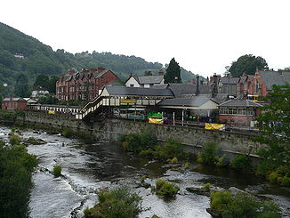
Der Dee bei Llangollen

Der Dee bei Llangollen

Daten
Lage Wales Wales, England England
Länge 110 km
Quelle am Osthang des Dduallt
52° 49′ 54″ N, 3° 45′ 45″ W52.831666666667-3.7625450
Quellhöhe ca. 450 mVorlage:Infobox Fluss/HÖHENBEZUG-QUELLE_fehlt
Mündung nordwestlich Chester in die Irische See53.338055555556-3.21583333333330Koordinaten: 53° 20′ 17″ N, 3° 12′ 57″ W
53° 20′ 17″ N, 3° 12′ 57″ W53.338055555556-3.21583333333330
Mündungshöhe 0 mVorlage:Infobox Fluss/HÖHENBEZUG-MÜNDUNG fehlt
Höhenunterschied ca. 450 m
Einzugsgebiet 1816,8 km2[1]dep1
Abflussmenge MQ: 29,71 m³/s

Der Dee, walisisch Afon Dyfrdwy, ist ein etwa 110 km langer Fluss im nördlichen Wales, der sich in die Irische See ergießt.

Der Dee entspringt in der Grafschaft Gwynedd an den Hängen des Dduallt in Snowdonia und fließt auf kurzem Weg zum Balasee. Von da aus wendet sich der Flusslauf nach Nordosten zur Ortschaft Corwen und dann ostwärts an Llangollen vorbei. Im Tal von Llangollen fließt der Dee unter dem von Thomas Telford 1805 für den Shropshire-Union-Kanal gebauten Pontcysyllte-Aquädukt hindurch.

Nachdem der Dee die walisische Bergregion verlassen hat, fließt er in Windungen nordwärts durch die Ebene von Cheshire auf Chester zu; hinter Chester wurde der Flusslauf kanalisiert. Die Mündung des Dee ist 19 km lang und 8 km breit, sehr seicht, mit Sandbänken und Marschen; der Hauptort an der Flussmündung ist Flint.

Einzelnachweise

  1. National Water Archive, Station Chester Weir

Wikimedia Foundation.

Игры ⚽ Поможем написать курсовую

Schlagen Sie auch in anderen Wörterbüchern nach:

  • List of rivers of Wales — This is a list of rivers of Wales, organised geographically, taken anti clockwise, from Hoylake on Wirral through to the M48 Bridge that separates the estuary of the River Wye from the River Severn. Tributaries are listed down the page in an… …   Wikipedia

  • River Dee, Wales — Geobox|River name = River Dee (Wales) native name = Afon Dyfrdwy other name = other name1 = image size = 312 image caption = The River Dee at Llangollen country = Wales country country1 = England country1 country2 = country2 state = state1 =… …   Wikipedia

  • River Dee (Wales) — For other River Dees in the United Kingdom, see River Dee (disambiguation). Coordinates: 53°21′14″N 3°13′33″W / 53.35389°N 3.22583°W / 53.35389; …   Wikipedia

  • List of Special Areas of Conservation in Wales — The following is a list of Special Areas of Conservation in Wales.* Aberbargoed Grasslands * Afon Eden – Cors Goch Trawsfynydd * Afon Gwyrfai a Llyn Cwellyn * Afon Teifi/ River Teifi * Afon Tywi/ River Tywi * Afonydd Cleddau/ Cleddau Rivers *… …   Wikipedia

  • List of Sites of Special Scientific Interest in Clwyd — This is a list of the Sites of Special Scientific Interest (SSSIs) in the Clwyd Area of Search. For SSSIs elsewhere in Wales, see List of SSSIs by Area of Search.* Afon Dyfrdwy (River Dee) * Alyn Valley Woods and Alyn Gorge Caves * Berwyn * Blaen …   Wikipedia

  • Ди (река в Уэльсе) — Ди Dee / Afon Dyfrdwy Река Ди в Честере Характеристика Длина …   Википедия

  • Ди (река, впадает в Ирландское море) — У этого термина существуют и другие значения, см. Ди (река). Ди Dee / Afon Dyfrdwy Река …   Википедия

  • Liste des cours d'eau d'Angleterre — Cet article présente une liste des cours d eau d Angleterre, classés par position géographique dans le sens inverse des aiguilles d une montre. Ils passent par l Angleterre et se jettent dans les mers qui bordent le pays. Pour l Esk, la Tweed, la …   Wikipédia en Français

  • Glyndyfrdwy — (pronounced IPA2|glɨ̞nˈdəvr.dʊɨ, approximately glin DUVR dooy ) or sometimes Glyn Dyfrdwy is a village in the modern county of Denbighshire, Wales. Location It is situated on the A5 road half way between Corwen and Llangollen in the valley of the …   Wikipedia

  • List of Special Areas of Conservation in England — The following is a list of Special Areas of Conservation in England* Arnecliff and Park Hole Woods * Asby Complex * Ashdown Forest * Aston Rowant * Avon Gorge Woodlands * Barnack Hills and Holes * Baston Fen * Bath and Bradford on Avon Bats *… …   Wikipedia

Share the article and excerpts

Direct link
Do a right-click on the link above
and select “Copy Link”