Eileach an Naoimh

Eileach an Naoimh

Vorlage:Infobox Insel/Wartung/Fläche fehltVorlage:Infobox Insel/Wartung/Höhe fehlt

Eileach an Naoimh
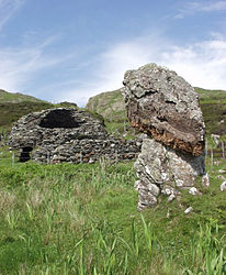
Mönchszelle und Menhir auf Eileach an Naoimh
Gewässer Firth of Lorne
Inselgruppe Garvellachs
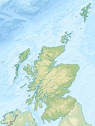
Geographische Lage 56° 13′ 20″ N, 5° 48′ 22″ W56.222222222222-5.8061111111111Koordinaten: 56° 13′ 20″ N, 5° 48′ 22″ W
Eileach an Naoimh (Schottland)
Eileach an Naoimh
Einwohner (unbewohnt)

Eileach an Naoimh ist eine schmale, langgestreckte, heute unbewohnte kleine Insel an der Westküste Schottlands. Der gälische Name bedeutet „Felsen des Heiligen“. Sie ist die südlichste der fünf Garvellachs (auch Isles of the Sea genannt), die im Firth of Lorne, südlich der Isle of Mull liegen und zum Argyll & Bute Council gehören.

Die Inselgruppe gehört zu den Inneren Hebriden. Die Garvellachs sind von Tobernorochy auf der Insel Luing aus per Boot zu erreichen.

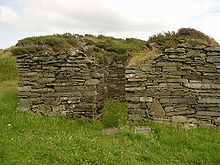
In frühchristlicher Zeit wurde hier ein Kloster oder eine Eremitage gegründet. Aus dieser Zeit stammt eine gut erhaltene doppelte Bienenkorbhütte. „Eithnes Grab“ besteht aus einer Einfriedung, die als Grab der Mutter von St. Columba angesehen wird. Eine der Platten ist mit einem Cross-Slab dekoriert. Die kirchliche Versorgung der Insel während des Mittelalters ist durch einen Friedhof mit drei Stein-Kreuzen und zwei kleinen Kapellen belegt. Die älteste ist rechteckig und stammt aus dem 11. oder 12. Jahrhundert. „The Harp“ (oder An Clarsach) ist ein natürlicher Felsbogen im Nordteil der Insel auf der steilen Westseite. Im Süden der Insel steht ein 1904 installiertes, im Jahre 2003 automatisiertes Leuchtfeuer.

Ruine der Klosterkapelle

Literatur

  • Anna and Graham Ritchie: Scotland – An Oxford Archaeological Guide. S. 113 Oxford University Press1998 ISBN 0-19-288002-0

Wikimedia Foundation.

Игры ⚽ Нужно решить контрольную?

Schlagen Sie auch in anderen Wörterbüchern nach:

  • Eileach An Naoimh — Géographie Pays  Royaume Uni Archipel Hébrides intérieures Localisation …   Wikipédia en Français

  • Eileach an naoimh — Géographie Pays  Royaume Uni Archipel Hébrides intérieures Localisation …   Wikipédia en Français

  • Eileach an Naoimh — Saltar a navegación, búsqueda Eileach an Naoimh es una isla deshabitada, localizada en el archipiélago de las Hébridas Interiores, en Escocia. Constituye la parte más meridional del archipiélago de las Garvellachs y se encuentra ubicada en el… …   Wikipedia Español

  • Eileach an Naoimh — Pour les articles homonymes, voir Holy Isle. Eileach an Naoimh Géographie Pays …   Wikipédia en Français

  • Eileach an Naoimh — Infobox Scottish island | latitude=56.21 longitude= 5.8 GridReference=NM645095 celtic name=Eileach an Naoimh norse name= meaning of name=rocky place of the saint area=convert|56|ha|acre|0|abbr=on area rank= 183 highest elevation=… …   Wikipedia

  • Hinba — ( gd. isles of the sea ) is an island in Scotland of unknown location that was the site of a small monastery associated with the Columban church on Iona. Although a number of details are known about the monastery and its early abbots, and various …   Wikipedia

  • Garvellachs — Islas Garvellachs (Garbh Eileaich) Vista de las Garvellachs Localización geográfica / administrativa …   Wikipedia Español

  • Beehive-hut — Bienenkorbhütte auf der Dingle Halbinsel vorzeitlicher Chlochán auf den Aran Islands (Inishmore) der Clochán na Carraige Bienenkorbhütte, auch Biene …   Deutsch Wikipedia

  • Bienenstock Hütten — Bienenkorbhütte auf der Dingle Halbinsel vorzeitlicher Chlochán auf den Aran Islands (Inishmore) der Clochán na Carraige Bienenkorbhütte, auch Biene …   Deutsch Wikipedia

  • Список островов Шотландии — Карта Внешних и Внутренних Гебрид Этот список содержит перечисление морских и пресноводных островов Шотландии (континентальная часть которой является частью острова Великобритания). Помимо того, в список включены связанные с рас …   Википедия

Share the article and excerpts

Direct link
Do a right-click on the link above
and select “Copy Link”