- Albany Island (Queensland)
-
Albany Island Lage der Torres-Strait-Inseln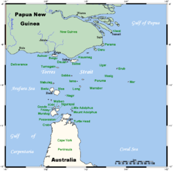
Gewässer Pazifischer Ozean Inselgruppe Manar-Inseln Geographische Lage 10° 43′ 50″ S, 142° 36′ 20″ O-10.73045142.6055166666728Koordinaten: 10° 43′ 50″ S, 142° 36′ 20″ O Länge 5,15 km Breite 1,09 km Fläche 6,07 km² Höchste Erhebung 28 m Einwohner (unbewohnt) Albany Island, auch Pabaju genannt, ist eine Insel im Südosten des Archipels der Torres-Strait-Inseln. Sie ist zugleich die Hauptinsel der Manar-Inseln, welche unmittelbar östlich vor der Nordostspitze Australiens liegen.
Albany ist leicht hügelig, rund fünf Kilometer lang (Nordwest nach Südost) und im Durchschnitt einen Kilometer breit. Verwaltungstechnisch gehört sie zu den Inner Islands, der südlichsten Inselregion im Verwaltungsbezirk Torres Shire des australischen Bundesstaats Queensland.
Die Insel ist unbewohnt.
Siehe auch
 Inselregionen, Hauptinseln und Inselgruppen im Archipel der Torres-Strait-Inseln
zu Papua-Neuguinea gehörge Torres-Strait-Inseln: Daru | Parama Island
Top Western: Boigu | Dauan | Saibai • Talbot-Inseln
Western: Badu Island | Mabuiag | Moa Island • Bellevue-Inseln
Central: Coconut Island | Sue Island | Yam Island | Yorke Island • Bourke-Inseln | The Three Sisters | Yorke-Inseln
Eastern: Darnley Island | Murray Island | Stephen Island • Murray-Inseln
Inner: Friday Island | Hammond Island | Horn Island | Packe Island | Prince of Wales Island | Thursday Island • Thursday-Inseln | Manar-Inseln

Wikimedia Foundation.