- Booby Island (Queensland)
-
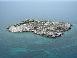
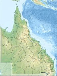
Booby Island (Queensland) Schrägluftbild Gewässer Torres-Straße Geographische Lage 10° 36′ 14″ S, 141° 54′ 40″ O-10.603888888889141.9111111111137Koordinaten: 10° 36′ 14″ S, 141° 54′ 40″ O Länge 360 m Breite 340 m Fläche 6 ha Höchste Erhebung 37 m Einwohner (unbewohnt) Landsat-Bild von Booby Island Booby Island ist eine kleine Insel in der Torres-Straße und gehört administrativ zu Queensland, Australien. Die Insel befindet sich 23 Kilometer westlich der Prince-of-Wales-Insel sowie 45 Kilometer nordwestlich der Kap-York-Halbinsel am westlichen Eingang der Torresstraße. Da die Passage dieses Gewässers äußerst schwierig ist, sanken hier im 19. Jahrhundert zahlreiche Schiffe. 1896 wurde schließlich ein 18 Meter hoher Leuchtturm errichtet.
Den Namen hat Booby Island von den Tölpelvögeln (englisch Booby).
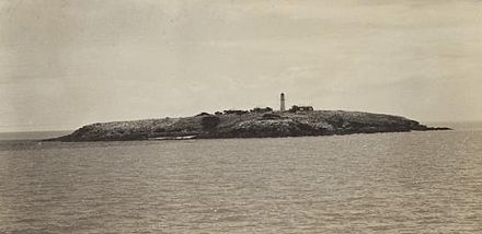
Historische Ansicht
Weblinks
- Russ Rowlett: Lighthouses of Australia: Queensland’s East Coast. The Lighthouse Directory. University of North Carolina at Chapel Hill. Abgerufen am 17. September 2011.
Commons: Booby Island – Sammlung von Bildern, Videos und AudiodateienInselregionen, Hauptinseln und Inselgruppen im Archipel der Torres-Strait-Inselnzu Papua-Neuguinea gehörige Torres-Strait-Inseln: Bristow Island | Daru Island | Parama Island • Kawai-Inseln | Talbot-Inseln
Top Western: Boigu | Dauan | Deliverance | Saibai | Turnagain • Talbot-Inseln
Western: Badu | Mabuiag | Moa | Portlock | Tobin • Bellevue-Inseln | Duncan-Inseln | Farewell-Inseln | Kulbi-Inseln
Central: Aureed | Bourke | Coconut | Sassie | Sue | Yam | Yorke • Bourke-Inseln | The Three Sisters | Yorke-Inseln
Eastern: Bramble | Darnley | Murray | Stephens • Murray-Inseln
Inner: Albany | Booby | Crab | Entrance | Friday | Goods | Hammond | Horn | Packe | Port Lihou | Prince-of-Wales | Thursday | Wednesday • Manar-Inseln | Red-Wallis-Inseln | Thursday-Inseln | Tuesday-Inseln
Wikimedia Foundation.
Schlagen Sie auch in anderen Wörterbüchern nach:
Booby Island (Queensland) — Booby Island is an island West of Muttee Heads at the tip of Cape York Peninsula within the Endeavour Strait Queensland, Australia. This island in the Torres Strait, south of Thursday Island and Prince of Wales Island.hipwrecksIn the 19th century … Wikipedia
Booby Island — ist der Name mehrerer Inseln: Booby Island (Queensland), Australien Booby Island (Seychellen) Booby Island (St. Kitts und Nevis) Diese Seite ist eine Begriffsklärung zur Unterscheidung mehrerer mit demselben Wo … Deutsch Wikipedia
Prince of Wales Island (Queensland) — For other islands named after the Prince of Wales, see Prince of Wales Island. Prince of Wales Island Native name: Muralag Muralug on map … Wikipedia
One Tree Island (Queensland) — One Tree Island IUCN Category Ia (Strict Nature Reserve) … Wikipedia
Moreton Island lighthouses — 1927 Plan of the northern tip of Moreton Island, showing the locations of Cape Moreton Light, North Point Light and Yellow Patch Light Moreton Island is a large sand island on the eastern side of Moreton Bay, on the coast of South East Queensland … Wikipedia
Double Island Point Light — Double Island Point Light, 2006 … Wikipedia
Magnetic Island — with Townsville suburbs in the foreground Palm Islands location Geography … Wikipedia
Dent Island Light — Dent Island Lightstation, 2007 … Wikipedia
Double Island Point — is a coastal headland in Queensland, Australia. It s the next headland north of Noosa and is within the Cooloola section of the Great Sandy National Park, at the southern end of Wide Bay. The point was named by Captain Cook when he passed it on… … Wikipedia
Dunk Island — Nearest town/city Mission Beach C … Wikipedia