Fulham Broadway (London Underground)
- Fulham Broadway (London Underground)
-
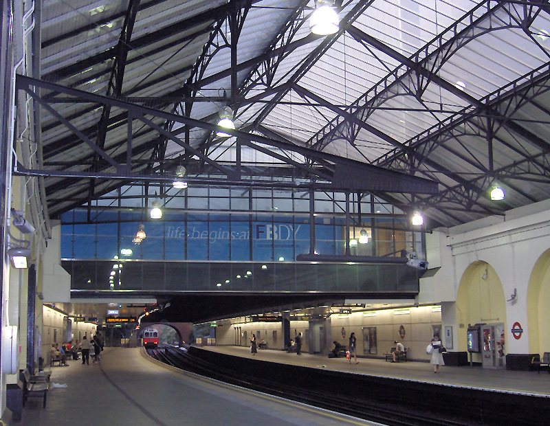
Fulham Broadway ist eine oberirdische Station der London Underground im Stadtbezirk London Borough of Hammersmith and Fulham. Sie liegt in der Travelcard-Tarifzone 2 an der gleichnamigen Straße und wird von der District Line bedient. Rund 200 Meter weiter östlich befindet sich Stamford Bridge, das Stadion des Fußballclubs FC Chelsea. Im Jahr 2007 nutzten 10,291 Millionen Fahrgäste die Station.[1]
Eröffnet wurde die Station am 1. März 1880 durch die Metropolitan District Railway (Vorgängergesellschaft der District Line) unter dem Namen Walham Green. 1905 entstand ein neues Stationsgebäude und am 2. März 1952 erhielt die Station ihren heutigen Namen. 2003 wurde rund um die Station ein Einkaufszentrum errichtet und es entstand ein neuer, direkter und rollstuhlgängiger Zugang zum Stadion. Das Stationsgebäude steht unter Denkmalschutz und wird von einem Restaurant der Kette T.G.I. Friday’s genutzt.
Einzelnachweise
- ↑ London Underground performance update
Weblinks
51.480277777778-0.19527777777779
Kategorien:
- Station der London Underground
- Verkehr (London Borough of Hammersmith and Fulham)
Wikimedia Foundation.
Schlagen Sie auch in anderen Wörterbüchern nach:
Fulham Broadway tube station — Fulham Broadway is a London Underground station on the Wimbledon branch of the District Line. It is between West Brompton and Parsons Green stations and is in Travelcard Zone 2. The station is located on Fulham Broadway (A304). It is notable as… … Wikipedia
Fulham Broadway (métro de Londres) — Fulham Broadway Entrée de la station Localisation Ville … Wikipédia en Français
London Underground — Infobox Public transit name = London Underground The Tube |thumb|Official logo. imagesize= 150px locale = Greater London, Chiltern, Epping Forest, Three Rivers and Watford transit type = Rapid transit began operation = 1863 system length = 400 km … Wikipedia
London Heliport — London Heliport … Deutsch Wikipedia
East Acton (London Underground) — Stationsgebäude Bahnsteige, Blick Richtung … Deutsch Wikipedia
Parsons Green (London Underground) — Stationsgebäude Parsons Green ist eine oberirdische Station der London Underground im Stadtbezirk London Borough of Hammersmith and Fulham. Sie liegt in der Travelcard Tarifzone 2 auf einem Viadukt über der Parsons Green Lane. Im Jahr 2007… … Deutsch Wikipedia
Liste der Stationen der London Underground — Dies ist die Liste der Stationen der London Underground, der U Bahn der britischen Hauptstadt London. Enthalten sind alle Stationen, die zurzeit in Betrieb sind oder sich im Bau befinden, ebenso Stationen, die vorübergehend wegen Bauarbeiten… … Deutsch Wikipedia
List of London Underground stations — This is a list of London Underground stations. It includes all stations currently open on the London Underground and Docklands Light Railway, as well as Shepherd s Bush (Central Line) which will reopen in October 2008. The London Underground and… … Wikipedia
London Borough of Wandsworth — Infobox London Borough | name = London Borough of Wandsworth short name = Wandsworth imagename = status = London borough | area rank = 331st area km2 = 34.26 ons code = 00BJ | adminhq = Wandsworth | ethnicity = 78.0% White 9.6% African Caribbean… … Wikipedia
London Borough of Ealing — Infobox London Borough | name = London Borough of Ealing short name = Ealing imagename = status = London borough | adminhq = Ealing Town Hall, Uxbridge Road, Ealing area rank = 293rd area km2 = 55.53 ons code = 00AJ | url =… … Wikipedia
 Stationshalle
 Commons: Fulham Broadway (London Underground) – Sammlung von Bildern, Videos und Audiodateien