Gannet Island

Gannet Island

Vorlage:Infobox Insel/Wartung/Fläche fehlt

Gannet Island
Gannet Island aus der Luft gesehen
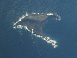
Gewässer Tasmansee
Geographische Lage 37° 58′ 19″ S, 174° 33′ 58″ O-37.971944444444174.5661111111115Koordinaten: 37° 58′ 19″ S, 174° 33′ 58″ O
Gannet Island (Neuseeland)
Gannet Island
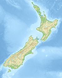
Höchste Erhebung 15 m
Einwohner (unbewohnt)

Gannet Island (in der Sprache der Māori Karewa) ist eine einzelne kleine Insel in der Tasmansee etwa 19 km vor Kāwhia Harbour an der Westküste der Nordinsel Neuseelands. Sie ist ein Naturschutzgebiet.[1] Hier befindet nach einer Zählung von 1980 die zweitgrößte neuseeländische Brutkolonie des Australischen Tölpels.[2]

Die Insel besteht aus den erodierten Resten eines bei Eruptionen von etwa 500.000 Jahren entstandenen Tuffringes. Sie ist als bedeutend jünger und im Aufbau verschieden von den Vulkangesteinen der nahegelegenen Küste bei Alexandra (Mount Karioi und Mount Pirongia) und Okete. Die Insel liegt am Ostrand des Nord-Taranaki-Grabens. Die Insel ist 15 m hoch und erstreckt sich etwa 65 m unter den Meeresspiegel.[3]

Die Insel beherbergt auch eine bedeutende Kolonie des Neuseeländischen Seebären. Die Māori verwendeten die Insel als Begräbnisplatz. Heute werden die Gewässer um die Insel zum Tauchen und Fischen genutzt.[2]

Quellen

(alle Quellen in englischer Sprache)

  1. Wildlife Sanctuary (Gannet Island) Order 1980
  2. a b Kingcountry.co.nz
  3. R. M. Briggs, M. D. Rosenberg, P. J. de Lange, T. Itaya, P. R. King and R. C. Price. (1997). Geology and geochemistry of Gannet (Karewa) Island, Tasman Sea: a rift-related nephelinitic tuff ring, New Zealand Journal of Geology and Geophysics, 40, 263-272.

Wikimedia Foundation.

Игры ⚽ Нужно решить контрольную?

Schlagen Sie auch in anderen Wörterbüchern nach:

  • Gannet Island — ( Karewa in Māori) is a small island some 19 kilometres (12 miles) offshore from Kawhia on the west coast of New Zealand s North Island. Protected as a wildlife sanctuary, [ [http://interim.legislation.govt.nz/libraries/contents/om… …   Wikipedia

  • Gannet — For other uses, see Gannet (disambiguation). Gannet Northern Gannets on Heligoland, a small German archipelago in the North Sea Scientific classification …   Wikipedia

  • Northern Gannet — Conservation status Least Concern ( …   Wikipedia

  • Cape Gannet — Colonie Cape Gannet, Birds Island, Lamberts Bay, South Africa Conservation status …   Wikipedia

  • Australasian Gannet — At Cape Kidnappers   …   Wikipedia

  • Funk Island — is a small, barren, isolated, uninhabited island approximately km to mi|60|wiki=yes northeast of Wesleyville, Newfoundland, Canada.Location map|Newfoundland|lon dir=W|lat dir=N lat deg = 49 lat min = 45 lat sec = 07 lon deg = 53 lon min = 11 lon… …   Wikipedia

  • Norfolk Island — Territory of Norfolk Island Norfolk Island …   Wikipedia

  • Mana Island, New Zealand — Mana Island Māori: Te Mana o Kupe Mana Island seen from Porirua …   Wikipedia

  • Cat Island (Tasmania) — Cat Island is a granite island, with an area of 39 ha, in south eastern Australia. It is part of Tasmania’s Babel Island Group, lying in eastern Bass Strait off the east coast of Flinders Island in the Furneaux Group.FaunaSeabirds and waders… …   Wikipedia

  • Alcatraz Island — Alcatraz redirects here. For other uses, see Alcatraz (disambiguation). Alcatraz Island IUCN Category V (Protected Landscape/Seascape) …   Wikipedia

Share the article and excerpts

Direct link
Do a right-click on the link above
and select “Copy Link”