Graham Island (Queen Charlotte Islands)
- Graham Island (Queen Charlotte Islands)
-
Vorlage:Infobox Insel/Wartung/Höhe fehlt
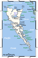
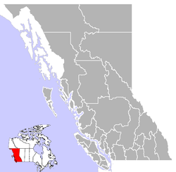
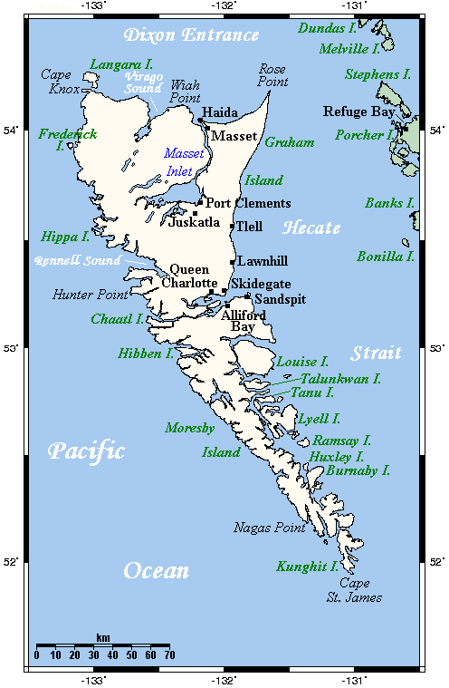
Graham Island (Haida: Haida Gwaii, „Land der Haida“) ist die Hauptinsel der Queen Charlotte Islands, einer Inselgruppe vor der Nordwestküste von British Columbia, Kanada im Pazifischen Ozean.
Lage
Die Insel besitzt eine Fläche von 6.361 km². Der Skidegate Channel, eine schmale Meerenge im Süden, trennt sie von der zweiten Hauptinsel, Moresby Island (Haida: Gwaii Hanas).
Die Hecate Strait, die Graham Island vom Festland British Columbias trennt, erreicht zwischen Rose Spit und Stephens Island ihre schmalste Stelle mit einer Breite von etwa 55 Kilometer.
Bevölkerung
Ein Großteil der etwa 4.500 Einwohner siedelt in den folgenden 6 Siedlungen:
- Juskatla - eine Holzfäller-Siedlung mit etwa 5 Einwohnern
- Masset - etwa 950 Einwohner am Ende des Yellowhead Highway
- Port Clements - etwa 450 Einwohner
- Queen Charlotte City - etwa 950 Einwohner
- Skidegate - Fährhafen der BC Ferries mit etwa 780 Einwohnern
- Tlell - Siedlung am Südende des Naikoon Provincial Park mit etwa 220 Einwohnern
Ein Großteil der Einwohner gehört dem Volk der Haida an, in Skidegate und Old Masset befinden sich die Tribal Centre des Councils der Haida Nation.
Infrastruktur
Der Service der BC Ferries stellt eine Verbindung zwischen Skidegate und Prince Rupert, sowie Skidegate und Alliford Bay auf Moresby Island zur Verfügung.
Der Yellowhead Highway ist die einzige Straße von überregionaler Bedeutung, darüber hinaus gibt es einige unbefestigte Straßen, welche sich größtenteils auf den Südosten der Insel konzentrieren.
Weblinks
Wikimedia Foundation.
Schlagen Sie auch in anderen Wörterbüchern nach:
Queen Charlotte Islands — Übersichtskarte der Inselgruppe Die Queen Charlotte Islands (Haida: Haida Gwaii) sind ein Archipel vor der Nord West Küste von British Columbia, Kanada. Die Queen Charlotte Islands bestehen aus den beiden Inseln Graham Island und Moresby Island… … Deutsch Wikipedia
Queen Charlotte Islands — Infobox Islands name = Queen Charlotte Islands image caption = image size = locator map custom = no native name = Haida Gwaii native name link = Haida language nickname = location = Pacific Ocean coordinates =… … Wikipedia
Queen Charlotte Islands caribou — Dawson s Caribou Conservation status Extinct Scientific classification Kingdom: Animalia Phylum … Wikipedia
Queen-Charlotte-Inseln — Übersichtskarte der Inselgruppe Die Queen Charlotte Islands (Haida: Haida Gwaii) sind ein Archipel vor der Nord West Küste von British Columbia, Kanada. Die Queen Charlotte Islands bestehen aus den beiden Inseln Graham Island und Moresby Island… … Deutsch Wikipedia
Queen Charlotte Islands — a group of islands in British Columbia off the W coast of Canada. 2222; 3970 sq. mi. (10,280 sq. km). * * * Group of about 150 islands (pop., 2001: 4,935) off western British Columbia, Canada. They have an area of 3,705 sq mi (9,596 sq km). The… … Universalium
Graham Island — See also Graham Island (disambiguation). Infobox Islands name = Graham image caption = Graham Island is the large northern island image size = locator Location map|Canada British Columbia|lat=53.442264|long= 132.242432 map custom = yes native… … Wikipedia
Queen Charlotte, British Columbia — Infobox Settlement official name = Village of Queen Charlotte other name = native name = nickname = settlement type = Village motto = imagesize = image caption = flag size = image seal size = image shield = shield size = city logo = citylogo size … Wikipedia
Queen Charlotte Mountains — Geobox | Range name=Queen Charlotte Mountains image caption=Tow Hill on Graham Island country=Canada region type=Province region=British Columbia parent=Insular Mountains highest=Mount Moresby highest elevation=1164 highest lat d=53|highest lat m … Wikipedia
1949 Queen Charlotte earthquake — Earthquake title = 1949 Queen Charlotte earthquake date = August 22, 1949 250px magnitude = 8.1 Mw depth = location = coord|53.62|N|133.27|W countries affected = Canada tsunami = aftershocks = casualties = NoneThe Queen Charlotte earthquake of… … Wikipedia
Skeena-Queen Charlotte Regional District — Skeena Queen Charlotte is a Regional District in British Columbia. It is located on British Columbia s west coast and includes the Queen Charlotte Islands, the largest of which are Graham Island and Moresby Island. Its administrative offices are… … Wikipedia