- Grorud
-
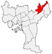 Lage von Grorud in Oslo
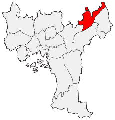
Grorud ist ein nordöstlicher Stadtteil der norwegischen Hauptstadt Oslo mit 25.461 Einwohnern (2008) und einer Größe von 7,04 km². Er umfasst die Stadtteilgebiete Ammerud, Grorud, Kalbakken, Rødtvet und Romsås. Der Stadtteil grenzt an Lillomarka und die Osloer Stadtteile Stovner, Alna und Bjerke.
Weblinks
 Stadtteile von Oslo
Alna | Bjerke | Frogner | Gamle Oslo | Grorud | Grünerløkka | Nordre Aker | Nordstrand | Sagene | St. Hanshaugen | Stovner | Søndre Nordstrand | Ullern | Vestre Aker | Østensjø
Wikimedia Foundation.
Schlagen Sie auch in anderen Wörterbüchern nach:
Grorud — Infobox Bydel name=Grorud idnumber=030110 city=Oslo capital= governor= governor as of= arearank= area=7.04 areapercent= population as of=2004 populationrank= population=24,452 populationpercent= populationdensity= webpage=www.bydel… … Wikipedia
Grorud — est un quartier (bydel) de la ville d Oslo en Norvège … Wikipédia en Français
Grorud Line — Infobox rail line name = Grorud Line nativename = Grorudbanen caption = Romsås Station on the Grorud Line type = Rapid transit system = Oslo T bane start = Tøyen end = Vestli stations = 16 open = October 16, 1966 close = owner =… … Wikipedia
Grorud (station) — Infobox T bane station name = Grorud caption = locale = Grorud municipality = Oslo line = Grorudbanen distance = 11.3 km elevation = 180.3 m coordinates = coord|59|57|40|N|10|52|53|E|display=title,inline|region:NO 03 scale:50000… … Wikipedia
Grorud Station — Infobox Norwegian station name = Grorud caption = locale = Grorud municipality = Oslo line = Hovedbanen distance = 10.50 km elevation = 127.0 m coordinates = start = 1854 architect = platforms = 2 owner = operator = Norges Statsbaner iata = t… … Wikipedia
Grorud Valley — The Grorud Valley (in Norwegian: Groruddalen ) is a broad valley in eastern Oslo. Four of Oslo s boroughs, Bjerke in the west, Alna in the south, Grorud in the north, and Stovner in the east, lie within the valley.The population of the valley is… … Wikipedia
Oslo Metro — Info Owner Ruter … Wikipedia
Common Tunnel — Grønland Station Overview Type Rapid transit … Wikipedia
Oslo T-bane — Infobox Public transit name = Oslo T bane imagesize = 57px imagesize2 = 300px locale = Oslo, Norway transit type = Rapid transit began operation = 31 May 1898 as suburban tram 22 May 1966 as T bane system length = 84.2 km (52.3 miles) lines = 6… … Wikipedia
East End and West End of Oslo — A map of central Oslo. Uelands gate, the traditional boundary line between the East End and the West End, is marked in black. The East End and West End (Norwegian: Østkanten og Vestkanten) are used as names for the two parts of Oslo, Norway,… … Wikipedia
Grorud

18+
© Academic, 2000-2026
- Kontaktieren Sie uns: Unterstützung, Werbung
Wörterbücher Export, schritte mit PHP, Joomla, Drupal, WordPress, MODx.